Manitoba Highway 6
| ||||
|---|---|---|---|---|
| Northern Woods and Water Route (section) | ||||
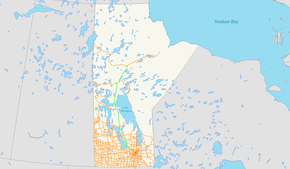 PTH 6 highlighted in green | ||||
| Route information | ||||
| Maintained by the Department of Infrastructure Provincial Government of Manitoba | ||||
| Length | 732 km (455 mi) | |||
| Existed | 1947 – present | |||
| Major junctions | ||||
| South end |
| |||
|
| ||||
| North end |
Thompson city limits highway continues as | |||
| Location | ||||
| Towns | Grosse Isle, Warren, Lundar, Eriksdale, Ashern, Grand Rapids | |||
| Highway system | ||||
| ||||

Provincial Trunk Highway 6 (PTH 6) is a provincial primary highway located in the Canadian province of Manitoba. It runs from the Perimeter Highway of Winnipeg to the Thompson south city limits. It is also the main highway connecting Winnipeg to northern Manitoba. The speed limit is 100 km/h. The route is also used to deliver nickel from the Thompson mine to the Royal Canadian Mint in Winnipeg. The portion of the highway between Ponton and Thompson was previously known as Highway 391.
There have been talks of extending PTH 6 North to Churchill and the Nunavut border. If plans to make a highway in Nunavut connecting from Churchill, and Arviat, Nunavut to Chesterfield Inlet, Nunavut go through, then the first ever major road connection to Nunavut will be made.
Route History
PTH 6 was designated in 1928 from Minnedosa to the Saskatchewan border southwest of Benito. In 1938-1939, the section east of Swan River became part of PTH 10. In 1947, the remainder was renumbered as PTH 31, and the current PTH 6 was designated.
Major intersections
| Division | Location | km | mi | Destinations | Notes |
|---|---|---|---|---|---|
| Rosser | | 0 | 0.0 | southern terminus of PTH 6 | |
| | 1 | 0.62 | south end of PR 236 overlap | ||
| | 2 | 1.2 | north end of PR 236 overlap | ||
| | Road 3 East | former PR 334 south | |||
| | 14 | 8.7 | |||
| Rockwood | | 14 | 8.7 | ||
| Woodlands | | 23 | 14 | ||
| Warren | 25 | 16 | |||
| | 35 | 22 | |||
| Woodlands | 39 | 24 | |||
| | 44 | 27 | |||
| | 46 | 29 | |||
| Lake Francis | Road 88 North | former PR 414 west | |||
| St. Laurent | St. Laurent | 68 | 42 | ||
| Coldwell | | Road 102 North - Oak Point | former PR 511 east | ||
| Clarkleigh | 91 | 57 | |||
| Lundar | 104 | 65 | |||
| West Interlake | Eriksdale | 123 | 76 | south end of PTH 68 overlap | |
| | 134 | 83 | north end of PTH 68 overlap; former PR 235 west | ||
| | 162 | 101 | south end of PR 325 overlap | ||
| Ashern | 164 | 102 | north end of PR 325 overlap | ||
| Grahamdale | Moosehorn | 174 | 108 | south end of PR 237 overlap | |
| | 176 | 109 | north end of PR 237 overlap | ||
| Steep Rock Junction | 195 | 121 | |||
| St. Martin Junction | 237 | 147 | |||
| | 240 | 150 | |||
| | Gypsumville | former PR 513 east | |||
| No. 21 | | 380 | 240 | former PR 327 west | |
| Grand Rapids | 414 | 257 | Bridge over Saskatchewan River | ||
| No. 22 | | 579 | 360 | former PR 391 west | |
| | 610 | 380 | |||
| | 627 | 390 | Wabowden | ||
| Mystery Lake | 702 | 436 | |||
| Thompson | 732 | 455 | northern terminus of PTH 6 | ||
| 1.000 mi = 1.609 km; 1.000 km = 0.621 mi | |||||
External links
- Official Name and Location - Declaration of Provincial Trunk Highways Regulation - The Highways and Transportation Act - Provincial Government of Manitoba
- Official Highway Map - Published and maintained by the Department of Infrastructure - Provincial Government of Manitoba (see Legend and Map#2, 4, 5, 6 & 7)
- Google Maps Search - Provincial Trunk Highway 6
Route map: