Northampton and Lamport Railway
| Northampton & Lamport Railway | |
|---|---|
|
| |
 Peckett 0-4-0ST Works No. 2104 with a train | |
| Locale | England |
| Terminus | Pitsford and Brampton |
| Commercial operations | |
| Name | Northampton to Market Harborough line ("Harborough Line") |
| Built by | London and North Western Railway |
| Original gauge | 4 ft 8 1⁄2 in (1,435 mm) standard gauge |
| Preserved operations | |
| Operated by | Northampton & Lamport Railway Preservation Society |
| Stations | 1 |
| Length | 1 1⁄2 miles (2.4 km) |
| Preserved gauge | 4 ft 8 1⁄2 in (1,435 mm) standard gauge |
| Commercial history | |
| Opened | 1858 |
| Closed | 1981 |
| Preservation history | |
| 1984 | Work started at (and around) Pitsford and Brampton station site |
| 1995 | Light Railway Order, Granted with First public passenger train operated |
| 1996 | Grand Re-opening (NLR re-opened, officially) |
| Headquarters | Pitsford and Brampton |
| Website | |
|
www | |
Northampton and Lamport Railway | |||||||||||||||||||||||||||||||||||||||||||||||||||||||||||||||||||||||||||||||||||||||||||||||||||||||||||||||||||||||||||||||||||||||||||||||||||||||||||||||||||||||||||||||||||||||||||||||||||||||||||||||||||||||||||||||||||||||||||||||||||||||||||||||||||||||||||||||||||||||||||||||||||||||||||||||||||||||||||||||||||||||||||||||||||||||||||||||||||||||||||||||||||||||||||||||||||||||||||||||||||||||||||||||||||||||||||||||||||||||||||||||||||||||||||||||||||||||||||||||||||||||||||||||||||||||||||||||||||||||
|---|---|---|---|---|---|---|---|---|---|---|---|---|---|---|---|---|---|---|---|---|---|---|---|---|---|---|---|---|---|---|---|---|---|---|---|---|---|---|---|---|---|---|---|---|---|---|---|---|---|---|---|---|---|---|---|---|---|---|---|---|---|---|---|---|---|---|---|---|---|---|---|---|---|---|---|---|---|---|---|---|---|---|---|---|---|---|---|---|---|---|---|---|---|---|---|---|---|---|---|---|---|---|---|---|---|---|---|---|---|---|---|---|---|---|---|---|---|---|---|---|---|---|---|---|---|---|---|---|---|---|---|---|---|---|---|---|---|---|---|---|---|---|---|---|---|---|---|---|---|---|---|---|---|---|---|---|---|---|---|---|---|---|---|---|---|---|---|---|---|---|---|---|---|---|---|---|---|---|---|---|---|---|---|---|---|---|---|---|---|---|---|---|---|---|---|---|---|---|---|---|---|---|---|---|---|---|---|---|---|---|---|---|---|---|---|---|---|---|---|---|---|---|---|---|---|---|---|---|---|---|---|---|---|---|---|---|---|---|---|---|---|---|---|---|---|---|---|---|---|---|---|---|---|---|---|---|---|---|---|---|---|---|---|---|---|---|---|---|---|---|---|---|---|---|---|---|---|---|---|---|---|---|---|---|---|---|---|---|---|---|---|---|---|---|---|---|---|---|---|---|---|---|---|---|---|---|---|---|---|---|---|---|---|---|---|---|---|---|---|---|---|---|---|---|---|---|---|---|---|---|---|---|---|---|---|---|---|---|---|---|---|---|---|---|---|---|---|---|---|---|---|---|---|---|---|---|---|---|---|---|---|---|---|---|---|---|---|---|---|---|---|---|---|---|---|---|---|---|---|---|---|---|---|---|---|---|---|---|---|---|---|---|---|---|---|---|---|---|---|---|---|---|---|---|---|---|---|---|---|---|---|---|---|---|---|---|---|---|---|---|---|---|---|---|---|---|---|---|---|---|---|---|---|---|---|---|---|---|---|---|---|---|---|---|---|---|---|---|---|---|---|---|---|---|---|---|---|---|---|---|---|---|---|---|---|---|---|---|---|---|---|---|---|---|---|---|---|---|---|---|---|---|---|---|---|---|---|---|---|---|---|---|---|---|---|---|---|---|---|---|---|---|---|---|---|---|---|---|---|---|---|---|---|---|---|---|---|---|---|
Brampton Valley Way
| |||||||||||||||||||||||||||||||||||||||||||||||||||||||||||||||||||||||||||||||||||||||||||||||||||||||||||||||||||||||||||||||||||||||||||||||||||||||||||||||||||||||||||||||||||||||||||||||||||||||||||||||||||||||||||||||||||||||||||||||||||||||||||||||||||||||||||||||||||||||||||||||||||||||||||||||||||||||||||||||||||||||||||||||||||||||||||||||||||||||||||||||||||||||||||||||||||||||||||||||||||||||||||||||||||||||||||||||||||||||||||||||||||||||||||||||||||||||||||||||||||||||||||||||||||||||||||||||||||||||
| |||||||||||||||||||||||||||||||||||||||||||||||||||||||||||||||||||||||||||||||||||||||||||||||||||||||||||||||||||||||||||||||||||||||||||||||||||||||||||||||||||||||||||||||||||||||||||||||||||||||||||||||||||||||||||||||||||||||||||||||||||||||||||||||||||||||||||||||||||||||||||||||||||||||||||||||||||||||||||||||||||||||||||||||||||||||||||||||||||||||||||||||||||||||||||||||||||||||||||||||||||||||||||||||||||||||||||||||||||||||||||||||||||||||||||||||||||||||||||||||||||||||||||||||||||||||||||||||||||||||
The Northampton & Lamport Railway is a standard gauge heritage railway in Northamptonshire, England. It is based at Pitsford and Brampton station, near the villages of Pitsford and Chapel Brampton, roughly 5 miles (8.0 km) north of Northampton.
Overview
The line between Northampton and Market Harborough was finally closed (by British Rail) on 16 August 1981, the intermediate stations on the route having been closed for many years.
In 1984 (just 3 years after the line's closure) a group was formed by Michael William Papworth (of Northampton) with the intention of re-opening a section of the line as a heritage railway. The site opened to the public shortly afterwards. Following the granting of a Light Railway Order, the line carried its first fare-paying passengers in November 1995. The official Grand Opening Ceremony took place (just 4 months later) on 31 March 1996.
Currently, passenger trains operate on a section of line approximately 1 1⁄2 miles (2.4 km) in length, departing from and arriving at the only station, Pitsford and Brampton.
However, As of November 2013, An extension south had currently been under construction which adds another 1⁄2 mile (0.80 km) of running line, with around 90% of track-relaying completed around Spring 2012. Once complete it will include a station with sidings and run-round loop at the former Boughton Crossing on the A5199 at the Northamptonshire village of Boughton.
A northern extension of the N&LR currently remains within the planning stage, but before work can start, however, extensive repairs are needed to Bridge 14 which carries the track over the River Nene. In addition Northamptonshire County Council, which owns the former trackbed, will not grant a lease on the land required for the extension until the NLR's southern extension (to as far as Boughton) is completed. The previous extension opened after several years' work and around £50,000 was spent on repairs to Bridge 13, (the same amount required for Bridge 14, when the NLR turns its intention northwards).
The signalling system, with two working signal boxes (and a third under construction), makes it one of the most comprehensive and detailed on any heritage railway of its size, within Preservation. The Booking Office at Pitsford and Brampton station was built using the disused Lamport signal box, originally located around 5 1⁄2 miles (8.9 km) away on/up the same line. It had since been converted in such a way that it can be easily converted back into a signal box if whenever required in the future.
A third signal box has been installed at the Boughton Terminus; the former Betley Road signal box from Crewe is being used following its restoration.
The Brampton Valley Way is a "linear park" offering a traffic-free route for walkers, cyclists and pedestrians, and which runs alongside the railway, separated by a stout safety fence. Access is also available to horse riders on other sections away from the railway.
The railway is open for viewing from 10:00 to 17:00 on Sundays. Train rides are available on Sundays from March to October, diesel hauled with steam-hauled trains for special events (subject to availability). Open from March to October and throughout December for Santa's visit.
Events
A number of special events take place throughout the year, the popular Santa Specials run throughout the month of December.
On 18 July 2007 the Railway at War Weekend, an event held at the railway every September, was named Best Event in the 2007 Northamptonshire Renaissance Heritage Awards.[1]
Locomotives
Steam
- GWR 2-8-0 2884 Class № 3862. Built in 1942. Under restoration.
- GWR 4-6-0 4900 Class № 5967 Bickmarsh Hall. Built in 1937. Under restoration.
- Peckett and Sons 0-4-0ST № 2104. Built in 1948. Withdrawn January 2017, awaiting overhaul.[2]
- Peckett and Sons 0-4-0ST No. 2130. Built in 1949. Operational.
- Peckett and Sons 0-6-0ST № 1378 "Westminster". Built in 1914 for the Fovant Military Railway[3] Under restoration.
- Andrew Barclay 0-4-0ST No 776 "Firefly". Built in 1896. Under restoration.
Main line diesel
- British Rail Class 47 Co-Co № 47205 - operational
Industrial diesel and shunters
- Ruston & Hornsby 4wDM 88DS № 1 "Merry Tom" - out of service
- Ruston & Hornsby 0-4-0 165DS № 764 "Sir Gyles Isham" (first locomotive to arrive on the line) - operational
- Ruston & Hornsby 0-6-0 165DS № 53 "Sir Alfred Wood" - under repair
- Fowler/Thomas Hill 0-4-0 DH № 146C "Bunty" - donated by Redland Aggregates - out of service
- Fowler 0-4-0 DH № 21 - awaiting restoration
Carriages
- British Rail Mark 2 TSO № 5174 - in service
- British Rail Mark 2 TSO № 5132, formerly named Clan Munro- operational
- British Rail Mark 2 BSO(T) № 9102. - out of service for repairs and reconfigure to former 9383.
- British Rail Mark 1 TSO № 3919. - on station as buffet seating - awaiting repairs
- British Rail Mark 1 RBR (Buffet Car) № 1647 - out of service for repairs
- British Rail Mark 1 NAV № 84031 - operational (as temporary Buffet)
Gallery
 The booking office and platform at Pitsford and Brampton
 The platform at Pitsford and Brampton Station
 Pitsford and Brampton signal box
 Pitsford Sidings signal box
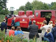 Steam locomotive 7646 "Northampton" officially named by the Mayor of Northampton
 Peckett 0-4-0ST Works No. 2104 in the yard, preparing for a day's use on passenger trains
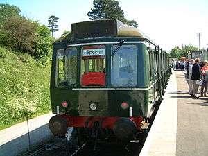 The first passenger train to cross Bridge 13, with nameplate from 1981 (Class 117 51402 has since moved to the Strathspey Railway)
 Boughton — end of the Brampton Valley Way which runs alongside the railway
 JCB excavator used in the railway's construction
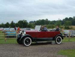 Stanley Steamer visiting an event at the railway
 Hunslet 0-6-0ST 'Ring Haw' and a short goods train
 Santa Special hauled by № 7646
- Last train from Northampton to Market Harborough. This was a one off special before the closure of the line back in 1981.
| Wikimedia Commons has media related to Northampton & Lamport Railway. |
References
- ↑ Northampton Chronicle & Echo, 19 July 2007
- ↑ Chambers, Brian, ed. (Winter 2016). "Fairwell to 2014 Peckett". Premier Line. No. 102. pp. 17–18.
- ↑ "Peckett B2 Class 0-6-0ST № 1378 "Westminster"". NLR. Retrieved 20 October 2013.