North Lanarkshire
| North Lanarkshire North Lanrikshire Siorrachd Lannraig a Tuath | |||
|---|---|---|---|
 | |||
| |||
| Coordinates: 55°49′44″N 3°55′19″W / 55.829°N 3.922°WCoordinates: 55°49′44″N 3°55′19″W / 55.829°N 3.922°W | |||
| Admin HQ | Motherwell | ||
| Government | |||
| • Body | North Lanarkshire Council | ||
| • Control | Labour minority (council NOC) | ||
| • MPs | |||
| • MSPs | |||
| Area | |||
| • Total | 181.4 sq mi (469.9 km2) | ||
| Area rank | Ranked 19th | ||
| Population (mid-2017 est.) | |||
| • Total | 340,000 | ||
| • Rank | Ranked 4th | ||
| • Density | 1,870/sq mi (723/km2) | ||
| ONS code | S12000044 | ||
| ISO 3166 code | GB-NLK | ||
| Website |
www | ||

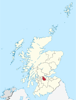
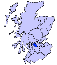
North Lanarkshire (Scots: North Lanrikshire; Scottish Gaelic: Siorrachd Lannraig a Tuath) is one of 32 council areas of Scotland. It borders onto the northeast of the City of Glasgow and contains many of Glasgow's suburbs and commuter towns and villages. It also borders East Dunbartonshire, Falkirk, Stirling, South Lanarkshire and West Lothian. The council covers parts of the traditional counties of Dunbartonshire, Lanarkshire and Stirlingshire.
The area was formed in 1996, largely made up from the Cumbernauld and Kilsyth, Motherwell and parts from the former Monklands District Council (1975–1996) as well as significant elements of Strathclyde Regional Council.
Principal towns (10,000+ in population)
- Cumbernauld – 52,270
- Coatbridge – 41,170
- Airdrie – 37,130
- Motherwell – 31,906
- Wishaw – 28,565
- Bellshill – 20,705
- Kilsyth – 10,100
Small towns and villages

- Allanton
- Annathill
- Auchinloch
- Banton
- Bargeddie
- Birkenshaw
- Bogside
- Bonkle
- Calderbank
- Caldercruix
- Cardowan
- Carfin
- Carnbroe
- Chapelhall
- Chryston
- Cleland
- Croy
- Dullatur
- Forrestfield
- Garrion Bridge
- Gartcosh
- Glenboig
- Glenmavis
- Greengairs
- Hareshaw
- Harthill
- Holytown
- Longriggend
- Luggiebank
- Millerston
- Mollinsburn
- Moodiesburn
- Morningside
- Mossend
- Muirhead
- Murdostoun
- Newarthill
- Newhouse
- Newmains
- New Stevenston
- Overtown
- Plains
- Queenzieburn
- Ravenscraig
- Riggend
- Salsburgh
- Shotts
- Stand
- Stepps
- Tannochside
- Viewpark
- Wattston
Political composition
| Party | Councillors | |
| Labour | 33 | |
| SNP | 31 | |
| Conservative | 8 | |
| Independent | 5 | |
References
- ↑ "North Lanarkshire Council -". mars.northlanarkshire.gov.uk.
External links
- North Lanarkshire at Curlie (based on DMOZ)
This article is issued from
Wikipedia.
The text is licensed under Creative Commons - Attribution - Sharealike.
Additional terms may apply for the media files.