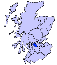
Muirhead, North Lanarkshire
Muirhead
| |
|---|---|
.jpg) Muirhead from the air | |
| Population | 1,390 [2] Mid-2012 estimate |
| OS grid reference | NS67SE60 |
| Lieutenancy area | |
| Country | Scotland |
| Sovereign state | United Kingdom |
| Post town | GLASGOW |
| Postcode district | G69 |
| Police | Scottish |
| Fire | Scottish |
| Ambulance | Scottish |
| EU Parliament | Scotland |
| UK Parliament | |
| Scottish Parliament | |
Muirhead is a small town approximately 7 miles (11 km) North-East of Glasgow city centre. Nearby villages and towns include Chryston, Garnkirk, Gartcosh, Lenzie and Stepps.[3] Muirhead has a population of around 1,390. It is a commuter town to Glasgow with road links with the A80/M80 and frequent bus services the 36, x37, x39 and x3. Muirhead is located approximately two miles from Gartcosh, Lenzie and Stepps railway stations.
History
.jpg)
The name may be related to the nearby Muirside.[4] Some old documents show Muirhead with various spellings including maps by for example William Forrest.[5]
Muirhead was little more than a hamlet before a new road was built just south of Chryston at the end of the 18th century.[6] Muirhead was formerly in the parish of Cadder.[7] Industries connected with Muirhead include coal and fire clay mining, brickmaking and distilling.[8] The New Statistical Account of 1845 reported 40 persons in 9 families at Muirhead.[9] Growth in the village followed the opening of The Garnkirk and Glasgow Railway in 1831.[10] Following the First World War a cenotaph was built in 1923 at Muirhead.[11] A primary school, St. Barbara's[12] on Elmira Road, was opened in 1933.[13]
Current Village
The suburb has a variety of shops including a Co-operative Food, newsagents, award-winning butcher[14], stationers and plenty of take-away food shops. Two bars which serve the area are the Muirhead Inn and The Crowwood.
The surrounding area has one high school and two primary schools.
A local development to the south of the village is Belhaven Park.


Notable residents include Celtic FC footballer Kieran Tierney.
.jpg)


References
- ↑ List of railway station names in English, Scots and Gaelic – NewsNetScotland
- ↑ "Estimated population of localities by broad age groups, mid-2012" (PDF). Retrieved 3 January 2018.
- ↑ "OS 25 inch 1892-1949". National Library of Scotland. Ordnance Survey. Retrieved 26 October 2017.
- ↑ Drummond, Peter, John (2014). An analysis of toponyms and toponymic patterns in eight parishes of the upper Kelvin basin (PDF). Glasgow: Glasgow University. p. 418. Retrieved 3 July 2017.
- ↑ "Old County Maps". NLS. Retrieved 27 January 2018.
- ↑ "Muirhead & Chryston". Monklands Memories. Retrieved 24 February 2018.
- ↑ Wilson, John Marius (1882). The gazetteer of Scotland. Edinburgh: W. & A.K. Johnston. p. 65. Retrieved 27 February 2018.
- ↑ "Muirhead". Gazetteer of Scotland. Retrieved 24 February 2018.
- ↑ Society for the Benefit of the Sons and Daughters of the Clergy (1845). The new statistical account of Scotland. Edinburgh and London: W. Blackwood and Sons. p. 408. Retrieved 31 December 2017.
- ↑ Kidd, Neil. "Chryston - 1861-1888". The Story of Chryston. Retrieved 24 February 2018.
- ↑ "Local History". Chryston and Muirhead Business Community. Retrieved 27 February 2018.
- ↑ "St. Barbara's Primary School Handbook". North Lanarkshire Council. Retrieved 27 February 2018.
- ↑ Kidd, Neil. "Education". The Story of Chryston. Retrieved 24 February 2018.
- ↑ "The pies have it for Muirhead butchers!". Kirkintilloch Herald. 9 January 2018. Retrieved 27 February 2018.
| Wikimedia Commons has media related to Muirhead. |