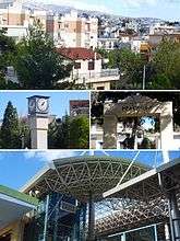
Irakleio, Attica
| Iraklio Ηράκλειο | |
|---|---|
 | |
 Iraklio Location within the region 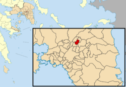 | |
| Coordinates: 38°3′N 23°46′E / 38.050°N 23.767°ECoordinates: 38°3′N 23°46′E / 38.050°N 23.767°E | |
| Country | Greece |
| Administrative region | Attica |
| Regional unit | North Athens |
| Government | |
| • Mayor | Pantelis Vlassopoulos |
| Area | |
| • Municipality | 4.638 km2 (1.791 sq mi) |
| Elevation | 150 m (490 ft) |
| Population (2011)[1] | |
| • Municipality | 49,642 |
| • Municipality density | 11,000/km2 (28,000/sq mi) |
| Time zone | UTC+2 (EET) |
| • Summer (DST) | UTC+3 (EEST) |
| Postal code | 141 xx |
| Area code(s) | 210 |
| Vehicle registration | Z |
| Website | www.iraklio.gr |
Iraklio (Greek: Ηράκλειο) is a suburb in the northeastern part of the Athens agglomeration, Greece, and a municipality of the Attica region.
Geography
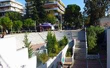
Iraklio is located about 8 km northeast of Athens city centre. The municipality has an area of 4.638 km2.[2] Its built-up area is continuous with those of the neighbouring suburbs Kalogreza, Nea Ionia, Metamorfosi, Lykovrysi and Pefki. Irakleio is subdivided into several quarters, including Palaio Irakleio, Neo Irakleio, Ano Irakleio and Prasinos Lofos. The main thoroughfare is Irakliou Avenue, which connects it with central Athens. The northern beltway of Athens, Motorway 6, passes through Irakleio. Irakleio is served by a subway station (Iraklio station) and by a commuter railway station (Iraklio railway station).
History
Iraklio was named after a sanctuary of Heracles that was located in the area in classical antiquity. Before the Greek War of Independence the village was known as Arakli. Iraklio was part of the city of Athens until 1925, when it became a separate community, elevated to municipality in 1948.[3] The earthquake of September 7, 1999, affected the area but caused minor damages.
- Princess Alice of Battenberg (1885-1969), founded the Orthodox religious order of Martha & Mary here after WW2.
Historical population
| Year | Population |
|---|---|
| 1981 | 37,833 |
| 1991 | 42,905 |
| 2001 | 45,926 |
| 2011 | 49,642 |
See also
References
- ↑ "Απογραφή Πληθυσμού - Κατοικιών 2011. ΜΟΝΙΜΟΣ Πληθυσμός" (in Greek). Hellenic Statistical Authority.
- ↑ "Population & housing census 2001 (incl. area and average elevation)" (PDF) (in Greek). National Statistical Service of Greece. Archived from the original (PDF) on September 21, 2015.
- ↑ EETAA local government changes
Places adjacent to Irakleio, Attica | ||||||||||
|---|---|---|---|---|---|---|---|---|---|---|
| ||||||||||
External links
Administrative division of the Attica Region | ||
|---|---|---|
| Regional unit of Central Athens | 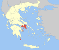 | |
| Regional unit of North Athens | ||
| Regional unit of West Athens | ||
| Regional unit of South Athens | ||
| Regional unit of Piraeus | ||
| Regional unit of East Attica | ||
| Regional unit of West Attica | ||
| Regional unit of Islands | ||
| ||