Zografou
| Zografou Ζωγράφου | |
|---|---|
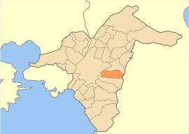 | |
 Zografou Location within the region 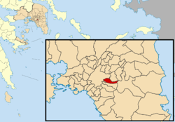 | |
| Coordinates: 37°58.7′N 23°46.3′E / 37.9783°N 23.7717°ECoordinates: 37°58.7′N 23°46.3′E / 37.9783°N 23.7717°E | |
| Country | Greece |
| Administrative region | Attica |
| Regional unit | Central Athens |
| Area | |
| • Municipality | 8.517 km2 (3.288 sq mi) |
| Elevation | 130 m (430 ft) |
| Population (2011)[1] | |
| • Municipality | 71,026 |
| • Municipality density | 8,300/km2 (22,000/sq mi) |
| Time zone | UTC+2 (EET) |
| • Summer (DST) | UTC+3 (EEST) |
| Postal code | 157 xx |
| Area code(s) | 210 |
| Vehicle registration | Z |
| Website | www.zografou.gov.gr |
Zografou (Greek: Ζωγράφου) is a suburb of approximately 71,000 in the eastern part of the Athens agglomeration, Greece. Actual the community reports a population of 150.000 inhabitants.[2] It was named after the Greek politician Ioannis Zografos. To the east of Zografou lies mount Hymettus. The area, being close to the centre of Athens, developed similar urban sprawl characteristics, with high-rise buildings of even 10 stories tall being the norm. The city is also home to the Athens university campus and polytechnical school campus and therefore, a great part of its population is university students. Zografou includes the smaller areas of Ilissia and Goudi.
Geography
Zografou is an inner suburb of Athens, located about 4 km east of Athens city centre. The municipality has an area of 8.517 km2.[3] Towards the east the municipality extends to the forested Hymettus mountain. The built-up area of Zografou is continuous with that of Athens. A large campus of the National and Kapodistrian University of Athens is situated in Ano Ilisia, the easternmost quarter of Zografou. Ano Ilisia derived its name from the river Ilisos, which starts at St Eleousa, now in the University campus.[4][5] Another quarter of Zografou is Goudi, in the northwestern part of the municipality. The main church of Zografou is consecrated to Agios Therapontas (Greek: Άγιος Θεράποντας). With Zografou having been built on the hills of Hymettus, a common sight around the city are some very steep uphill streets.
Transport
Zografou is served by bus lines 140 (Polygono - Glyfada), 220 (Ano Ilisia - Akadimia), 221 (Panepistimioupoli - Akadimia), 230 (Akropoli - Zografou), 235 (Zografou - Akadimia), 250 (Panepistimioupoli - Evangelismos station), 608 (Galatsi - Akadimia - Nekr. Zografou), 622 (Goudi - Ano Galatsi) and 815 (Goudi - Tavros).[6] The eastern beltway Motorway 64 passes through the municipality.
History
After the departure of the Ottomans from the area in the 1830s, the area came into the ownership of Ioannis Koniaris, mayor of Athens from 1851 to 1854, and Leonidas Vournazos.
In 1902, Eleni Vournazos, widow of Leonidas, sells 1,250 stremma of the Kouponia/Goudi area to Ioannis Zografos (died 1927), a Member of Parliament for the Nationalist Party and university professor. Dividing it into plots, he sold them for installments of 112 drachma per month. The first houses were erected in 1919. Within ten years, 100 had been built. At this time, the foundations of the Church of St. Theraponta were erected.
In 1929, the area, now known as Zografou, was split from the city of Athens and became an independent community. It was elevated to a municipality in 1947,[7] its first president being Sotirios Zografos, the son of Ioannis. In 1935, the area of Kouponia (now Ano Ilisia) was incorporated into the community.
Scientific Centers, Museums and others
- Dimitri Kitsikis Public Foundation"
- Gounaropoulos Museum, dedicated to the works of painter Giorgios Gounaropoulos. It was founded in 1979.
- Marika Kotopouli Museum, a museum of modern art, founded in 1990 and housed in the 1926 villa of actress Marika Kotopouli
Sports
Zografou hosts the local sport teams Asteras Zografou, football club founded in 1965 and Filathlitikos B.C., basketball club founded in 1986. In addition, the sport club Ilisiakos, founded in 1927, is based in Ilisia a district that is shared between Municipalities of Athens and Zografou.
| Sport clubs based in Zografou | |||
|---|---|---|---|
| Club | Founded | Sports | Achievements |
| Asteras Zografou | 1965 | Football | Earlier presence in Beta Ethniki |
| Filathlitikos B.C. | 1986 | Basketball | Earlier presence in A2 Ethniki basketball |
Historical population
| Historical population | ||
|---|---|---|
| Year | Pop. | ±% |
| 1981 | 84,548 | — |
| 1991 | 80,492 | −4.8% |
| 2001 | 76,115 | −5.4% |
| 2011 | 71,026 | −6.7% |
Notable people
- Dimitri Kitsikis (1935–) Royal Society of Canada
- Nikos Kourkoulos (1934–2007) actor
- Marika Kotopouli (1887–1954) actress
- Giannis Antetokounmpo
- Kostas Eftaxias[8] (1986-present) exceptional Civil Engineer
Gallery
 Odos Papagou in Zografou
 Church of St. Thomas
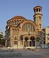 Church of St. Therapont
 Villa Zografou
See also
References
- ↑ "Απογραφή Πληθυσμού - Κατοικιών 2011. ΜΟΝΙΜΟΣ Πληθυσμός" (in Greek). Hellenic Statistical Authority.
- ↑ "Η ιστορία της πόλης | ΔΗΜΟΣ ΖΩΓΡΑΦΟΥ". zografou.gov.gr. Retrieved 6 October 2017.
- ↑ "Population & housing census 2001 (incl. area and average elevation)" (PDF) (in Greek). National Statistical Service of Greece. Archived from the original (PDF) on 21 September 2015.
- ↑ "Νεότερη ιστορία - ο Δήμος μας", zografou.gr, accessed 31 August 2008.
- ↑ "Aπό την εκδήλωση στο Ζωγράφου για την βίλα Archived November 8, 2008, at the Wayback Machine.", indymedia.gr, accessed 31 August 2008.
- ↑ "404 Not Found". oasa.gr. Retrieved 6 October 2017.
- ↑ "EETAA local government changes". web3.eetaa.gr:8080. Retrieved 6 October 2017.
- ↑ "Μαθηματική προσομοίωση παράκτιων υδροφορέων με το λογισμικό Feflow" (in Greek). Νάνου, Αικατερίνη, Μπαλτάς, Ευάγγελος, Παπανικολάου, Παναγιώτης, Μπαλτάς, Ευάγγελος, Παπανικολάου, Παναγιώτης, Νάνου, Αικατερίνη. 2014-05-21.
External links
| Wikimedia Commons has media related to Zografou. |
- City of Zografou official website (in Greek)
- News site for City of Zografou (in Greek)
Places adjacent to Zografou | ||||||||||
|---|---|---|---|---|---|---|---|---|---|---|
| ||||||||||
Administrative division of the Attica Region | ||
|---|---|---|
| Regional unit of Central Athens | 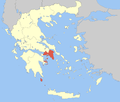 | |
| Regional unit of North Athens | ||
| Regional unit of West Athens | ||
| Regional unit of South Athens | ||
| Regional unit of Piraeus | ||
| Regional unit of East Attica | ||
| Regional unit of West Attica | ||
| Regional unit of Islands | ||
| ||