National Register of Historic Places listings in Oktibbeha County, Mississippi
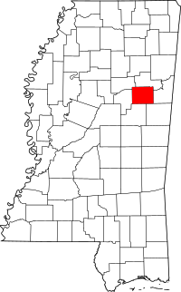
Location of Oktibbeha County in Mississippi
This is a list of the National Register of Historic Places listings in Oktibbeha County, Mississippi.
This is intended to be a complete list of the properties and districts on the National Register of Historic Places in Oktibbeha County, Mississippi, United States. Latitude and longitude coordinates are provided for many National Register properties and districts; these locations may be seen together in a map.[1]
There are 25 properties and districts listed on the National Register in the county.
- This National Park Service list is complete through NPS recent listings posted October 11, 2018.[2]
Current listings
| [3] | Name on the Register[4] | Image | Date listed[5] | Location | City or town | Description |
|---|---|---|---|---|---|---|
| 1 | Bardwell House | July 16, 1992 (#92000890) |
309 Blackjack Road 33°26′53″N 88°46′56″W / 33.448056°N 88.782222°W |
Starkville | Constructed circa 1855 | |
| 2 | Bell House | October 29, 1992 (#92001480) |
1280 Mississippi Highway 25, S. 33°26′11″N 88°49′06″W / 33.436389°N 88.818333°W |
Starkville | ||
| 3 | Thomas Battle Carroll House | May 1, 1991 (#91000531) |
304 S. Jackson St. 33°27′36″N 88°48′51″W / 33.46°N 88.814167°W |
Starkville | ||
| 4 | The Cedars | October 10, 1985 (#85003003) |
Old W. Point Rd. 33°28′31″N 88°48′04″W / 33.475278°N 88.801111°W |
Starkville | ||
| 5 | Downtown Starkville Historic District | July 25, 2012 (#12000433) |
Roughly bounded by Jefferson, N. Montgomery, & Yeates Sts., & railroad 33°27′48″N 88°48′52″W / 33.463311°N 88.81453°W |
Starkville | ||
| 6 | C. E. Gay House | January 3, 1991 (#90002108) |
110 E. Gillespie St. 33°27′28″N 88°48′55″W / 33.457778°N 88.815278°W |
Starkville | ||
| 7 | Gillespie-Jackson House | November 6, 1986 (#86003127) |
Southeastern corner of the junction of Mississippi Highways 12 and 25 33°27′13″N 88°49′17″W / 33.453611°N 88.821389°W |
Starkville | ||
| 8 | Greensboro Street Historic District | June 14, 1982 (#82003112) |
Greensboro St.; also Ernest Jones Jr. Dr., Greensboro St., Louisville St., Main St., W., Raymond St., and Yeates St. 33°27′42″N 88°49′29″W / 33.461667°N 88.824722°W |
Starkville | Second set of boundaries represents a boundary increase of July 10, 2008 | |
| 9 | Herman Mound and Village Site | March 17, 1993 (#93000137) |
Address Restricted |
Starkville | ||
| 10 | Hotel Chester | January 18, 1985 (#85000099) |
217-223 E. Main St. 33°27′50″N 88°48′51″W / 33.463889°N 88.814167°W |
Starkville | ||
| 11 | Lampkin-Owens House | November 24, 1980 (#80002298) |
117 N. Montgomery St. 33°27′56″N 88°48′38″W / 33.465556°N 88.810556°W |
Starkville | ||
| 12 | Lyon's Bluff Site | April 22, 1976 (#76001105) |
Address Restricted |
Starkville | ||
| 13 | Magruder-Newsom House | August 30, 1984 (#84002284) |
306 S. Jackson St. 33°27′36″N 88°48′51″W / 33.46°N 88.814167°W |
Starkville | ||
| 14 | Meadow Woods Plantation House | September 7, 2001 (#01000946) |
2479 Oktoc Rd. 33°22′04″N 88°45′43″W / 33.367778°N 88.761944°W |
Starkville | ||
| 15 | Montgomery Hall | 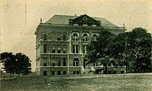 |
March 26, 1975 (#75001054) |
Mississippi State University campus 33°27′13″N 88°47′29″W / 33.453611°N 88.791389°W |
Starkville | Constructed 1902-03 using Beaux-Arts architectural style[6] |
| 16 | Nash Street Historic District | June 24, 1993 (#93000572) |
525 University Dr. and 101-117 N. Nash St. 33°27′47″N 88°48′14″W / 33.463056°N 88.803889°W |
Starkville | ||
| 17 | Odd Fellows Cemetery | 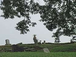 |
July 24, 1990 (#90001064) |
Junction of U.S. Route 82 and Henderson St. 33°28′00″N 88°49′15″W / 33.466667°N 88.820833°W |
Starkville | |
| 18 | Oktibbeha Gardens Subdivision Historic District | September 28, 2017 (#100001682) |
Roughly bounded by Critz & N. Montgomery Sts., Old West Point Rd. & Dr. Martin Luther King Jr. Dr. E. 33°28′08″N 88°48′29″W / 33.468971°N 88.808108°W |
Starkville | ||
| 19 | Dossey A. Outlaw Plantation | April 11, 2002 (#02000354) |
2173 Oktoc Rd. 33°23′07″N 88°46′27″W / 33.385278°N 88.774167°W |
Starkville | ||
| 20 | Overstreet School Historic District | October 23, 1992 (#92001398) |
Roughly bounded by Hogan, Montgomery, Gillespie, Jackson, Wood, and Washington Sts. and the Illinois Central railroad tracks 33°27′34″N 88°48′48″W / 33.459444°N 88.813333°W |
Starkville | ||
| 21 | Emma and Ed Rogers House | September 28, 2017 (#100001684) |
Longview Rd. 33°24′16″N 88°51′29″W / 33.404444°N 88.858056°W |
Starkville | ||
| 22 | Starkville Colored Cemetery | June 2, 2014 (#14000277) |
N. side of University Dr., W. of N. Nash & E. of Hartness Sts. 33°27′46″N 88°48′25″W / 33.462908°N 88.806842°W |
Starkville | ||
| 23 | John M. Stone Cotton Mill | April 29, 1975 (#75001055) |
Gillespie St. 33°27′26″N 88°48′09″W / 33.457222°N 88.8025°W |
Starkville | ||
| 24 | Textile Building | 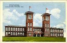 |
May 12, 1975 (#75001056) |
South of Starkville on the Mississippi State University campus 33°27′08″N 88°47′30″W / 33.452222°N 88.791667°W |
Starkville | Constructed in 1900 using Italianate, Mission & Romanesque architectural styles. Oldest academic building on the Mississippi State University campus.[7] |
| 25 | Walker-Critz House |  |
March 22, 1989 (#89000171) |
414 Chapin St. 33°28′01″N 88°48′29″W / 33.466944°N 88.808056°W |
Starkville |
See also
| Wikimedia Commons has media related to National Register of Historic Places in Oktibbeha County, Mississippi. |
References
- ↑ The latitude and longitude information provided in this table was derived originally from the National Register Information System, which has been found to be fairly accurate for about 99% of listings. For about 1% of NRIS original coordinates, experience has shown that one or both coordinates are typos or otherwise extremely far off; some corrections may have been made. A more subtle problem causes many locations to be off by up to 150 yards, depending on location in the country: most NRIS coordinates were derived from tracing out latitude and longitudes from USGS topographical quadrant maps created under the North American Datum of 1927, which differs from the current, highly accurate WGS84 GPS system used by most on-line maps. Chicago is about right, but NRIS longitudes in Washington are higher by about 4.5 seconds, and are lower by about 2.0 seconds in Maine. Latitudes differ by about 1.0 second in Florida. Some locations in this table may have been corrected to current GPS standards.
- ↑ "National Register of Historic Places: Weekly List Actions". National Park Service, United States Department of the Interior. Retrieved on October 11, 2018.
- ↑ Numbers represent an ordering by significant words. Various colorings, defined here, differentiate National Historic Landmarks and historic districts from other NRHP buildings, structures, sites or objects.
- ↑ National Park Service (2009-03-13). "National Register Information System". National Register of Historic Places. National Park Service.
- ↑ The eight-digit number below each date is the number assigned to each location in the National Register Information System database, which can be viewed by clicking the number.
- ↑ Montgomery Hall
- ↑ Textile Building
| Topics | |
|---|---|
| Lists by states |
|
| Lists by insular areas | |
| Lists by associated states | |
| Other areas | |
| |
Municipalities and communities of Oktibbeha County, Mississippi, United States | ||
|---|---|---|
| City | | |
| Towns | ||
| CDP | ||
| Unincorporated communities | ||
| Ghost town | ||
| Footnotes | ‡This populated place also has portions in an adjacent county or counties | |
This article is issued from
Wikipedia.
The text is licensed under Creative Commons - Attribution - Sharealike.
Additional terms may apply for the media files.