| [3] |
Name on the Register[4] |
Image |
Date listed[5] |
Location |
City or town |
Description |
|---|
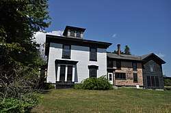
| 1 |
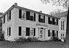
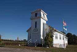
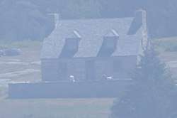
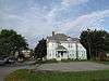
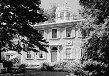
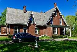
Ebenezer Alden House |
|
April 28, 1975
(#75000100) |
Off State Route 131
44°12′44″N 69°16′03″W / 44.212222°N 69.2675°W / 44.212222; -69.2675 (Ebenezer Alden House) |
Union |
|
| 2 |
Allen's Island |
|
December 15, 1983
(#83003646) |
In Muscongus Bay[6]
43°52′16″N 69°18′42″W / 43.871111°N 69.311667°W / 43.871111; -69.311667 (Allen's Island) |
St. George |
|
| 3 |
American Boathouse |
|
February 19, 1982
(#82000761) |
Atlantic Ave.
44°12′40″N 69°03′48″W / 44.211111°N 69.063333°W / 44.211111; -69.063333 (American Boathouse) |
Camden |
|
| 4 |
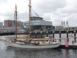
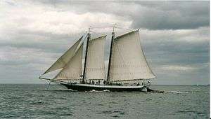
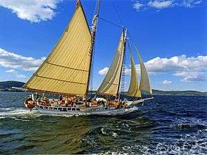
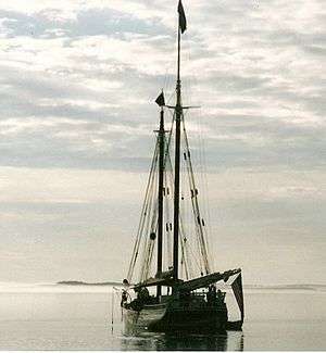
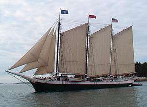
American Eagle (schooner) |
|
December 4, 1991
(#91002064) |
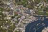
Rockland Harbor
44°06′32″N 69°06′32″W / 44.108889°N 69.108889°W / 44.108889; -69.108889 (American Eagle (schooner)) |
Rockland |
National Historic Landmark |
| 5 |
Joe Amesbury Place |
|
March 11, 1982
(#82000760) |
Address Restricted
|
North Haven |
|
| 6 |
Beechnut Hut Historic District |
|
July 10, 2003
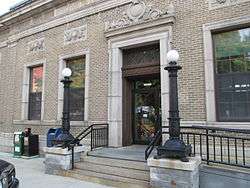
(#03000617) |
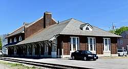
316 Beech Hill Rd.
44°10′07″N 69°06′15″W / 44.168611°N 69.104167°W / 44.168611; -69.104167 (Beechnut Hut Historic District) |
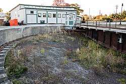
Rockport |
|
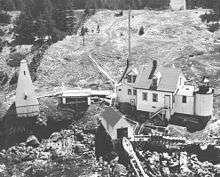
| 7 |
Bortz-Lewis Site |
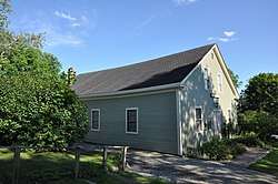
|
March 11, 1982
(#82000762) |
Address Restricted
|
North Haven |
|
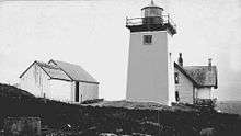
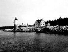
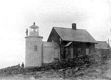
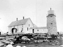
| 8 |
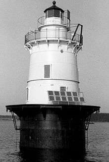
Browns Head Light Station |
|
January 27, 1983
(#83000460) |
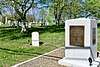
Browns Head
44°06′42″N 68°54′35″W / 44.111667°N 68.909722°W / 44.111667; -68.909722 (Browns Head Light Station) |
Vinalhaven |
|
| 9 |
Bull Rock |
|
March 11, 1982
(#82000763) |
Address Restricted
|
North Haven |
|
| 10 |
Benjamin Burton Garrison Site |
|
September 9, 1983
(#83000461) |
Address Restricted
|
Cushing |
|
| 11 |
Cabot I Site |
|
March 11, 1982
(#82000764) |
Address Restricted
|
North Haven |
|
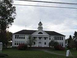
| 12 |
Camden Great Fire Historic District |
|
January 9, 2007
(#06001221) |
Elm and Main Sts.
44°12′35″N 69°03′57″W / 44.209722°N 69.065833°W / 44.209722; -69.065833 (Camden Great Fire Historic District) |
Camden |
|
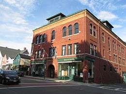
| 13 |
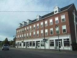
Camden Opera House Block |
|
December 29, 1986
(#86003539) |
Off U.S. Route 1
44°12′32″N 69°04′01″W / 44.208889°N 69.066944°W / 44.208889; -69.066944 (Camden Opera House Block) |
Camden |
|
| 14 |
Camden Amphitheater and Public Library |
|
February 27, 2013
(#13000285) |
55 Main St.
44°12′41″N 69°03′51″W / 44.2115°N 69.0642°W / 44.2115; -69.0642 (Camden Amphitheater and Public Library) |
Camden |
|
| 15 |
Camden Yacht Club |
|
January 11, 1980
(#80000378) |
Bay View St.
44°12′26″N 69°03′43″W / 44.207222°N 69.061944°W / 44.207222; -69.061944 (Camden Yacht Club) |
Camden |
|
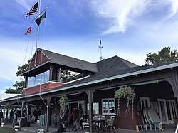
| 16 |
Chestnut Street Historic District |
|
March 22, 1991
(#91000325) |
Chestnut St. from Elm to Beacon Ave., including parts of Penobscot, Pleasant and Wood Sts., and Dillingham Pt.
44°12′13″N 69°03′43″W / 44.203611°N 69.061944°W / 44.203611; -69.061944 (Chestnut Street Historic District) |
Camden |
|
| 17 |
The Common |
|
November 7, 2007
(#07001151) |
Between Common and Burkett Rds.
44°12′41″N 69°16′30″W / 44.211389°N 69.275°W / 44.211389; -69.275 (The Common) |
Union |
|
| 18 |
Conway House |
|
December 23, 1969
(#69000010) |
Conway Rd.
44°12′01″N 69°04′52″W / 44.200278°N 69.081111°W / 44.200278; -69.081111 (Conway House) |
Camden |
|
| 19 |
Crocker Site |
|
March 11, 1982
(#82000765) |
Address Restricted
|
North Haven |
|
| 20 |
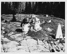
Curtis Island Light |
|
May 17, 1973
(#73000263) |
3.8 miles from Camden Harbor in Penobscot Bay
44°12′07″N 69°03′03″W / 44.201944°N 69.050833°W / 44.201944; -69.050833 (Curtis Island Light) |
Camden |
|
| 21 |
Farnsworth Homestead |
|
May 25, 1973
(#73000241) |
21 Elm St.
44°06′11″N 69°06′39″W / 44.103056°N 69.110833°W / 44.103056; -69.110833 (Farnsworth Homestead) |
Rockland |
|
| 22 |
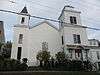
Finnish Congregational Church and Parsonage |
|
June 24, 1994
(#94000639) |
Eastern side of State Route 131, 0.9 miles south of its junction with U.S. Route 1
44°04′18″N 69°09′43″W / 44.071667°N 69.161944°W / 44.071667; -69.161944 (Finnish Congregational Church and Parsonage) |
South Thomaston |
|
| 23 |
Gaunt Neck Site Complex |
|
December 28, 2005
(#05001467) |
Address Restricted
43°58′59″N 69°18′20″W / 43.983056°N 69.305556°W / 43.983056; -69.305556 (Gaunt Neck Site Complex) |
Cushing |
|
| 24 |
Georges River Canal |
|
March 5, 1970
(#70000048) |
Upper Falls of the Georges River in Warren to the Union town line, extending to Quantabacook Pond in Searsmont
44°15′N 69°15′W / 44.25°N 69.25°W / 44.25; -69.25 (Georges River Canal) |
Appleton, Union, and Warren |
|
| 25 |
Goose Rocks Light Station |
|
January 21, 1988
(#87002267) |
East Entrance to the Fox Islands Thorofare
44°08′07″N 68°49′52″W / 44.135278°N 68.831111°W / 44.135278; -68.831111 (Goose Rocks Light Station) |
North Haven |
|
| 26 |
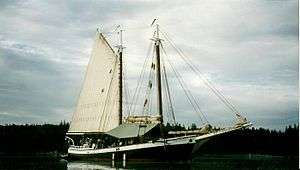
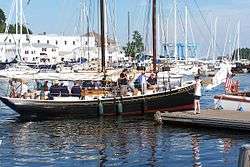
Grace Bailey (two-masted schooner) |
|
October 1, 1990
(#90001466) |
Camden Harbor
44°12′36″N 69°03′50″W / 44.21°N 69.063889°W / 44.21; -69.063889 (Grace Bailey (two-masted schooner)) |
Camden |
National Historic Landmark |
| 27 |
Gooden Grant House |
|
December 18, 2013
(#13000926) |
1 Head Harbor
44°01′27″N 68°37′07″W / 44.024248°N 68.618636°W / 44.024248; -68.618636 (Gooden Grant House) |
Isle au Haut |
|
| 28 |
Gushee Family House |
|
October 8, 1998
(#98001235) |
2868 Sennebec Rd.
44°17′13″N 69°14′54″W / 44.286944°N 69.248333°W / 44.286944; -69.248333 (Gushee Family House) |
Appleton |
|
| 29 |
Heron Neck Light Station |
|
January 21, 1988
(#87002266) |
Heron Neck on Greens Island
44°01′31″N 68°51′45″W / 44.025278°N 68.8625°W / 44.025278; -68.8625 (Heron Neck Light Station) |
Vinalhaven |
|
| 30 |
High Street Historic District |
|
January 5, 1989
(#88001843) |
Roughly High St. between Main St. and Sherman Point Rd.; also the junction of Main St. and Atlantic Ave.
44°12′58″N 69°03′40″W / 44.216111°N 69.061111°W / 44.216111; -69.061111 (High Street Historic District) |
Camden |
Main and Atlantic intersection represents a boundary increase September 24, 1999 |
| 31 |
Indian Island Light Station |
|
March 23, 1988
(#87002539) |
Indian Island in Rockport Harbor
44°09′55″N 69°03′42″W / 44.165278°N 69.061667°W / 44.165278; -69.061667 (Indian Island Light Station) |
Rockport |
|
| 32 |
Isaac H. Evans (schooner) |
|
December 4, 1991
(#91002061) |
Rockland Harbor
44°06′32″N 69°06′32″W / 44.108889°N 69.108889°W / 44.108889; -69.108889 (Isaac H. Evans (schooner)) |
Rockland |
National Historic Landmark |
| 33 |
Isle Au Haut Light Station |
|
January 21, 1988
(#87002265) |
Robinson Point
44°03′53″N 68°39′07″W / 44.064722°N 68.651944°W / 44.064722; -68.651944 (Isle Au Haut Light Station) |
Isle Au Haut |
|
| 34 |
J. & E. Riggin (schooner) |
|
December 4, 1991
(#91002062) |
Rockland Harbor
44°06′26″N 69°06′23″W / 44.107222°N 69.106389°W / 44.107222; -69.106389 (J. & E. Riggin (schooner)) |
Rockland |
National Historic Landmark |
| 35 |
Thomas King Inscription |
|
May 7, 1979
(#79000152) |
Address Restricted
|
Cushing |
|
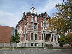
| 36 |
Knox County Courthouse |
|
April 18, 1977
(#77000075) |
62 Union St.
44°06′14″N 69°06′43″W / 44.103889°N 69.111944°W / 44.103889; -69.111944 (Knox County Courthouse) |
Rockland |
|
| 37 |
Land's End Historic District |
|
September 8, 2011
(#11000633) |
Marshall Point & Cottage Rds., Lentine & Land's End Lns.
43°55′16″N 69°15′19″W / 43.921111°N 69.255278°W / 43.921111; -69.255278 (Land's End Historic District) |
Saint George |
|
| 38 |
Lermond Mill |
|
December 27, 1984
(#84000499) |
Payson Rd.
44°12′51″N 69°13′28″W / 44.214159°N 69.224443°W / 44.214159; -69.224443 (Lermond Mill) |
Union |
|
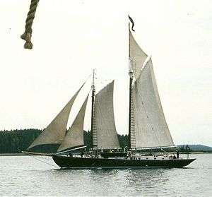
| 39 |
Lewis R. French (schooner) |
|
December 4, 1991
(#82005263) |
Camden Harbor
44°12′37″N 69°03′46″W / 44.2104°N 69.0627°W / 44.2104; -69.0627 (Lewis R. French (schooner)) |
Camden |
National Historic Landmark |
| 40 |
Main Street Historic District |
|
June 7, 1978
(#78000182) |
Main St. from Limerock to Winter Sts.; also 428-497 Main St.
44°06′14″N 69°06′34″W / 44.103889°N 69.109444°W / 44.103889; -69.109444 (Main Street Historic District) |
Rockland |
Second set of addresses represents a boundary increase, listed January 4, 2012 |
| 41 |
Marshall Point Light Station |
|
March 23, 1988
(#87002262) |
Marshall Point in Port Clyde Harbor
43°55′02″N 69°15′42″W / 43.917222°N 69.261667°W / 43.917222; -69.261667 (Marshall Point Light Station) |
Port Clyde |
|
| 42 |
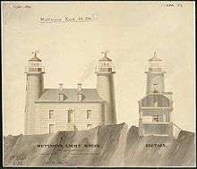
Matinicus Rock Light Station |
|
March 14, 1988
(#88000149) |
Matinicus Rock
43°47′06″N 68°51′16″W / 43.785°N 68.854444°W / 43.785; -68.854444 (Matinicus Rock Light Station) |
Matinicus Isle |
|
| 43 |
Joseph and Hannah Maxcy Homestead |
|
July 28, 2004
(#04000743) |
630 S. Union Rd.
44°11′47″N 69°15′50″W / 44.196389°N 69.263889°W / 44.196389; -69.263889 (Joseph and Hannah Maxcy Homestead) |
Union |
|
| 44 |
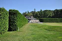
Megunticook Golf Club |
|
July 22, 1993
(#93000636) |
212 Calderwood Ln.
44°11′03″N 69°03′49″W / 44.184167°N 69.063611°W / 44.184167; -69.063611 (Megunticook Golf Club) |
Rockport |
Misspelled "Mequnticook" in the National Register listing. |
| 45 |
Mercantile (schooner) |
|
October 1, 1990
(#82005265) |
Camden Harbor
44°12′38″N 69°03′46″W / 44.210556°N 69.062778°W / 44.210556; -69.062778 (Mercantile (schooner)) |
Camden |
Designated a National Historic Landmark on December 4, 1991 |
| 46 |
Mosquito Island House |
|
September 29, 1983
(#83000462) |
South of St. George on Mosquito Island
43°55′21″N 69°13′22″W / 43.9225°N 69.222778°W / 43.9225; -69.222778 (Mosquito Island House) |
St. George |
|
| 47 |
Mullen's Cove |
|
March 30, 1984
(#84001382) |
Address Restricted
|
North Haven |
|
| 48 |
Murch Family House |
|
March 25, 1993
(#93000205) |
Southeastern side of Calderwood Neck, 2 miles northeast of North Haven Rd.
44°06′00″N 68°49′05″W / 44.1°N 68.818056°W / 44.1; -68.818056 (Murch Family House) |
Vinalhaven |
|
| 49 |
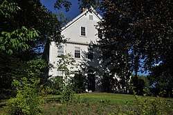
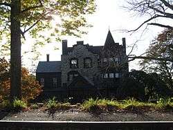
Norumbega |
|
July 12, 1974
(#74000174) |
High St.
44°13′04″N 69°03′26″W / 44.217778°N 69.057222°W / 44.217778; -69.057222 (Norumbega) |
Camden |
|
| 50 |
Norumbega Carriage House |
|
February 19, 1982
(#82000766) |
High St.
44°13′00″N 69°03′25″W / 44.216667°N 69.056944°W / 44.216667; -69.056944 (Norumbega Carriage House) |
Camden |
|
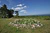
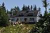
| 51 |
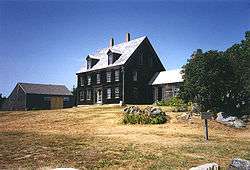
Olson House |
|
August 31, 1995
(#93001114) |
Eastern side of Hathorn Point Rd.
43°58′54″N 69°16′09″W / 43.981667°N 69.269167°W / 43.981667; -69.269167 (Olson House) |
South Cushing vicinity |
Andrew Wyeth spent 30 summers at the house and is buried on the grounds. National Historic Landmark designation June 23, 2011. |
| 52 |
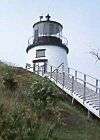
Owls Head Light Station |
|
January 18, 1978
(#78000183) |
Northeast of Owls Head on W. Penobscot Bay
44°05′30″N 69°02′41″W / 44.091667°N 69.044722°W / 44.091667; -69.044722 (Owls Head Light Station) |
Owls Head |
|
| 53 |
Pleasant River Grange No. 492 |
|
October 8, 1999
(#99001190) |
Round Island Rd., 0.15 miles east of its junction with N. Haven Rd.
44°04′33″N 68°50′20″W / 44.075833°N 68.838889°W / 44.075833; -68.838889 (Pleasant River Grange No. 492) |
Vinalhaven |
|
| 54 |
Rankin Block |
|
November 7, 1978
(#78000184) |
600-610 Main St.
44°06′32″N 69°06′38″W / 44.108889°N 69.110556°W / 44.108889; -69.110556 (Rankin Block) |
Rockland |
|
| 55 |
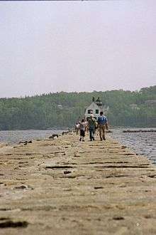
Rockland Breakwater |
|
April 11, 2003
(#03000203) |
South of Jameson Point
44°06′14″N 69°04′41″W / 44.103889°N 69.078056°W / 44.103889; -69.078056 (Rockland Breakwater) |
Rockland |
|
| 56 |
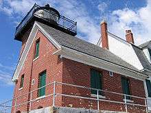
Rockland Breakwater Lighthouse |
|
March 20, 1981
(#81000067) |
Rockland Harbor
44°06′14″N 69°04′40″W / 44.103889°N 69.077778°W / 44.103889; -69.077778 (Rockland Breakwater Lighthouse) |
Rockland |
|
| 57 |
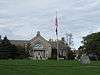
Rockland Public Library |
|
July 10, 1979
(#79000153) |
Union St.
44°06′19″N 69°06′45″W / 44.105278°N 69.1125°W / 44.105278; -69.1125 (Rockland Public Library) |
Rockland |
|
| 58 |
Rockland Railroad Station |
|
February 7, 1978
(#78000327) |
Union St.
44°06′03″N 69°06′41″W / 44.100833°N 69.111389°W / 44.100833; -69.111389 (Rockland Railroad Station) |
Rockland |
|
| 59 |
Rockland Residential Historic District |
|
April 15, 1987
(#86003513) |
Roughly bounded by Granite, Union, Masonic, Broad, Limerock, and Broadway Sts.
44°06′18″N 69°06′53″W / 44.105°N 69.114722°W / 44.105; -69.114722 (Rockland Residential Historic District) |
Rockland |
|
| 60 |
Rockland Turntable and Engine House |
|
June 24, 1993
(#90001953) |
Park St. west of the Rockland railroad station
44°06′04″N 69°07′23″W / 44.101111°N 69.123056°W / 44.101111; -69.123056 (Rockland Turntable and Engine House) |
Rockland |
|
| 61 |
Rockport Historic District |
|
May 28, 1976
(#76000099) |
Irregular pattern along Pascal Ave. from Russell, Union, and Winter Sts. on the north to School St. on the south
44°11′08″N 69°04′28″W / 44.185556°N 69.074444°W / 44.185556; -69.074444 (Rockport Historic District) |
Rockport |
|
| 62 |
Rockport Historic Kiln Area |
|
January 26, 1970
(#70000090) |
On the western side of the mouth of the Goose River at its confluence with Rockport Harbor
44°11′11″N 69°04′27″W / 44.186389°N 69.074167°W / 44.186389; -69.074167 (Rockport Historic Kiln Area) |
Rockport |
|
| 63 |
Saddleback Ledge Light Station |
|
March 14, 1988
(#88000158) |
Saddleback Ledge at Isle Au Haut Bay
44°00′51″N 68°43′36″W / 44.014167°N 68.726667°W / 44.014167; -68.726667 (Saddleback Ledge Light Station) |
Vinalhaven |
|
| 64 |
Sail Loft |
|
October 28, 1977
(#77000076) |
Off State Route 131
43°57′55″N 69°12′36″W / 43.965278°N 69.21°W / 43.965278; -69.21 (Sail Loft) |
Tenants Harbor |
|
| 65 |
Security Trust Building |
|
January 20, 1978
(#78000185) |
Elm and Main Sts.
44°06′13″N 69°06′35″W / 44.103611°N 69.109722°W / 44.103611; -69.109722 (Security Trust Building) |
Rockland |
|
| 66 |
Spite House |
|
August 13, 1974
(#74000175) |
Deadman's Point
44°10′31″N 69°03′18″W / 44.175278°N 69.055°W / 44.175278; -69.055 (Spite House) |
Rockport |
|
| 67 |
Star of Hope Lodge |
|
February 19, 1982
(#82000767) |
Maine St.
44°02′52″N 68°49′59″W / 44.047778°N 68.833056°W / 44.047778; -68.833056 (Star of Hope Lodge) |
Vinalhaven |
|
| 68 |
Stephen Taber (schooner) |
|
July 30, 1984
(#84001386) |
Rockland Harbor
44°06′20″N 69°06′27″W / 44.1056°N 69.1075°W / 44.1056; -69.1075 (Stephen Taber (schooner)) |
Rockland |
National Historic Landmark |
| 69 |
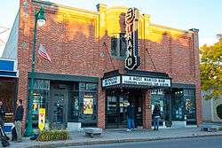
Strand Theatre |
|
December 2, 2004
(#04001284) |
345 Main St.
44°06′10″N 69°06′33″W / 44.102778°N 69.109167°W / 44.102778; -69.109167 (Strand Theatre) |
Rockland |
|
| 70 |
Surprise (schooner) |
|
June 14, 1991
(#91000771) |
Camden Harbor
44°12′38″N 69°03′48″W / 44.210556°N 69.063333°W / 44.210556; -69.063333 (Surprise (schooner)) |
Camden |
|
| 71 |
Tenants Harbor Light Station |
|
November 20, 1987
(#87002026) |
Southern Island
43°57′43″N 69°11′18″W / 43.961944°N 69.188333°W / 43.961944; -69.188333 (Tenants Harbor Light Station) |
Tenants Harbor |
|
| 72 |
Thomaston Historic District |
|
May 2, 1974
(#74000176) |
Runs along US 1 between Wadsworth St. and State Route 131
44°04′38″N 69°10′54″W / 44.077222°N 69.181667°W / 44.077222; -69.181667 (Thomaston Historic District) |
Thomaston |
|
| 73 |
George Thorndike House |
|
January 11, 1983
(#83000463) |
State Route 73
44°03′21″N 69°07′23″W / 44.055857°N 69.123017°W / 44.055857; -69.123017 (George Thorndike House) |
South Thomaston |
|
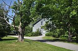
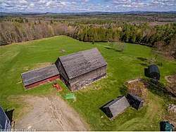
| 74 |
Tillson Farm Barn |
|
December 18, 1990
(#90001902) |
Warrenton Rd. southeast of its junction with Commercial St.
44°07′49″N 69°05′23″W / 44.130278°N 69.089722°W / 44.130278; -69.089722 (Tillson Farm Barn) |
Glen Cove |
|
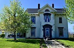
| 75 |
Gen. Davis Tillson House |
|
January 11, 1983
(#83000464) |
157 Talbot Ave.
44°06′34″N 69°07′19″W / 44.109444°N 69.121944°W / 44.109444; -69.121944 (Gen. Davis Tillson House) |
Rockland |
|
| 76 |
Tolman Cemetery |
|
October 12, 2017
(#100001741) |
39 Lake Ave.
44°07′33″N 69°07′14″W / 44.125827°N 69.120629°W / 44.125827; -69.120629 (Tolman Cemetery) |
Rockland |
|
| 77 |
Turner Farm II |
|
March 11, 1982
(#82000768) |
Address Restricted
|
North Haven |
|
| 78 |
Turner Farm Site |
|
March 26, 1976
(#76000100) |
Address Restricted
|
North Haven |
|
| 79 |
Union Church of Vinalhaven |
|
July 19, 1984
(#84001388) |
E. Main St.
44°02′54″N 68°49′52″W / 44.048333°N 68.831111°W / 44.048333; -68.831111 (Union Church of Vinalhaven) |
Vinalhaven |
|
| 80 |
Union Meeting House (Appleton) |
|
October 8, 2014
(#14000836) |
2875 Sennebec Rd.
44°17′15″N 69°14′51″W / 44.2875°N 69.2475°W / 44.2875; -69.2475 (Union Meeting House (Appleton)) |
Appleton |
|
| 81 |
Union Town House (Former) |
|
December 31, 2001
(#01001419) |
128 Town House Rd.
44°12′47″N 69°16′30″W / 44.213056°N 69.275°W / 44.213056; -69.275 (Union Town House (Former)) |
Union |
|
| 82 |
US Post Office-Camden Main |
|
September 25, 1986
(#86002960) |
Chestnut St.
44°12′31″N 69°03′53″W / 44.208611°N 69.064722°W / 44.208611; -69.064722 (US Post Office-Camden Main) |
Camden |
|
| 83 |
Victory Chimes (Schooner) |
|
June 24, 1996
(#93000637) |
North End Shipyard, Rockland Harbor
44°06′41″N 69°06′14″W / 44.111389°N 69.103889°W / 44.111389; -69.103889 (Victory Chimes (Schooner)) |
Rockland |
National Historic Landmark |
| 84 |
The Vinalhaven Galamander |
|
July 1, 1970
(#70000049) |
Bandstand Park
44°02′53″N 68°49′53″W / 44.047919°N 68.831251°W / 44.047919; -68.831251 (The Vinalhaven Galamander) |
Vinalhaven |
|
| 85 |
Vinalhaven Public Library |
|
January 5, 1989
(#88003014) |
Carver St.
44°02′55″N 68°49′55″W / 44.048611°N 68.831944°W / 44.048611; -68.831944 (Vinalhaven Public Library) |
Vinalhaven |
|
| 86 |
Moses Webster House |
|
April 1, 1998
(#98000309) |
Atlantic Ave., 0.05 miles east of the junction of Main St. and Atlantic Ave.
44°02′51″N 68°49′53″W / 44.0475°N 68.831389°W / 44.0475; -68.831389 (Moses Webster House) |
Vinalhaven |
|
| 87 |
Wharf House |
|
October 16, 1991
(#91001508) |
Southeast of the junction of Main and Smith Sts.
44°07′37″N 68°52′16″W / 44.126944°N 68.871111°W / 44.126944; -68.871111 (Wharf House) |
North Haven |
|
| 88 |
Whitehead Lifesaving Station |
|
October 12, 1988
(#88001839) |
Southern side of Whitehead Island
43°58′43″N 69°07′57″W / 43.978611°N 69.1325°W / 43.978611; -69.1325 (Whitehead Lifesaving Station) |
Sprucehead |
|
| 89 |
Whitehead Light Station |
|
March 14, 1988
(#88000154) |
Eastern side of Whitehead Island
43°58′47″N 69°07′30″W / 43.979722°N 69.125°W / 43.979722; -69.125 (Whitehead Light Station) |
Tenants Harbor |
|
| 90 |
Whitney Farm |
|
March 17, 2015
(#15000087) |
215 Whitney Rd.
44°19′44″N 69°13′50″W / 44.329°N 69.2305°W / 44.329; -69.2305 (Whitney Farm) |
Appleton |
Extends into Searsmont in Waldo County |
| 91 |
Timothy and Jane Williams House |
|
December 21, 2005
(#05001441) |
34 Old County Rd.
44°06′09″N 69°08′34″W / 44.1025°N 69.142778°W / 44.1025; -69.142778 (Timothy and Jane Williams House) |
Rockland |
|