Maine State Route 131
| ||||
|---|---|---|---|---|
 | ||||
| Route information | ||||
| Maintained by MaineDOT | ||||
| Length | 58.49 mi[1] (94.13 km) | |||
| Major junctions | ||||
| South end | Drift Inn Road / Glenmere Road in St. George | |||
| North end |
| |||
| Location | ||||
| Counties | Knox, Waldo | |||
| Highway system | ||||
| ||||

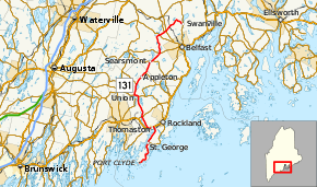
State Route 131 (SR 131) is a 58 1⁄2-mile-long (94.1 km) state route in the U.S. state of Maine. Its southern terminus is in the St. George community of Port Clyde, at a dead end near the Port Clyde Harbor. Its northern terminus is in Swanville, at the intersection with SR 141.[2]
Major junctions
| County | Location | mi[1] | km | Destinations | Notes |
|---|---|---|---|---|---|
| Knox | St. George | 0.00 | 0.00 | Dead end at Port Clyde Harbor | |
| 8.82 | 14.19 | Southern terminus of SR 73 | |||
| Thomaston | 14.12 | 22.72 | Southern end of US 1 concurrency | ||
| 15.89 | 25.57 | Northern end of US 1 concurrency | |||
| Warren | 19.67 | 31.66 | |||
| Union | 26.31 | 42.34 | Southern end of SR 17 / SR 235 concurrencies | ||
| 26.97 | 43.40 | Northern end of SR 235 concurrency | |||
| 27.41 | 44.11 | Northern end of SR 17 concurrency | |||
| Appleton | 30.65 | 49.33 | Southern end of SR 105 concurrency | ||
| 35.29 | 56.79 | Northern end of SR 105 concurrency | |||
| Waldo | Searsmont | 38.73 | 62.33 | Southern end of SR 173 concurrency | |
| 39.60 | 63.73 | Northern end of SR 173 concurrency | |||
| Belmont | 42.85 | 68.96 | Southern end of SR 3 concurrency | ||
| 43.30 | 69.68 | Northern end of SR 3 concurrency | |||
| Waldo | 49.15 | 79.10 | |||
| 50.71 | 81.61 | Southern terminus of SR 203 | |||
| 51.38 | 82.69 | ||||
| Swanville | 58.49 | 94.13 | |||
1.000 mi = 1.609 km; 1.000 km = 0.621 mi
| |||||
References
- 1 2 "Maine DOT Map Viewer". Maine Office of GIS. Retrieved August 2, 2017.
- ↑ Google (August 2, 2017). "Maine State Route 131" (Map). Google Maps. Google. Retrieved August 2, 2017.
External links
This article is issued from
Wikipedia.
The text is licensed under Creative Commons - Attribution - Sharealike.
Additional terms may apply for the media files.