National Register of Historic Places listings in Carroll County, Mississippi
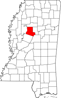
Location of Carroll County in Mississippi
This is a list of the National Register of Historic Places listings in Carroll County, Mississippi.
This is intended to be a complete list of the properties and districts on the National Register of Historic Places in Carroll County, Mississippi, United States. Latitude and longitude coordinates are provided for many National Register properties and districts; these locations may be seen together in a map.[1]
There are 11 properties and districts listed on the National Register in the county.
- This National Park Service list is complete through NPS recent listings posted October 11, 2018.[2]
Current listings
| [3] | Name on the Register[4] | Image | Date listed[5] | Location | City or town | Description |
|---|---|---|---|---|---|---|
| 1 | Abiaca Creek Bridge | March 22, 2004 (#04000218) |
Nebo Rd., about 0.3 miles north of Mississippi Highway 430, near Black Hawk 33°19′57″N 89°56′57″W / 33.3325°N 89.949167°W |
Vaiden | ||
| 2 | Carrollton Historic District | 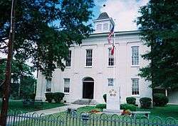 |
November 27, 1978 (#78001590) |
Mississippi Highway 35 33°30′33″N 89°55′16″W / 33.509167°N 89.921111°W |
Carrollton | |
| 3 | Cotesworth | 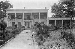 |
June 9, 1978 (#78001592) |
North of North Carrollton on Old Grenada Rd. 33°32′13″N 89°54′33″W / 33.537028°N 89.909028°W |
North Carrollton | |
| 4 | French Site (22HO565) | November 6, 1986 (#86002328) |
Address Restricted |
Oklahoma | Extends into Holmes County | |
| 5 | James Z. George Law Office | January 13, 1972 (#72000687) |
Washington St. between Lexington and Green Sts. 33°30′28″N 89°55′09″W / 33.507875°N 89.919139°W |
Carrollton | ||
| 6 | Malmaison Site | .jpg) |
August 25, 1970 (#70000317) |
Address Restricted |
Carrollton | |
| 7 | Merrill's Store | January 13, 1972 (#72000688) |
Jackson and Lexington Sts. 33°30′26″N 89°55′09″W / 33.507222°N 89.919167°W |
Carrollton | ||
| 8 | Midway Methodist Church and Cemetery | November 30, 2011 (#11000868) |
County Road 31 33°18′12″N 89°50′20″W / 33.303464°N 89.838967°W |
Vaiden vicinity | ||
| 9 | Rowland Site | June 23, 1978 (#78001591) |
Address Restricted |
Greenwood | ||
| 10 | Teoc Creek Site | May 6, 1971 (#71000445) |
Address Restricted |
Avalon | ||
| 11 | Vaiden High School | November 5, 2009 (#09000883) |
504 Mulberry St. 33°19′51″N 89°44′41″W / 33.330939°N 89.744853°W |
Vaiden |
See also
| Wikimedia Commons has media related to National Register of Historic Places in Carroll County, Mississippi. |
References
- ↑ The latitude and longitude information provided in this table was derived originally from the National Register Information System, which has been found to be fairly accurate for about 99% of listings. For about 1% of NRIS original coordinates, experience has shown that one or both coordinates are typos or otherwise extremely far off; some corrections may have been made. A more subtle problem causes many locations to be off by up to 150 yards, depending on location in the country: most NRIS coordinates were derived from tracing out latitude and longitudes from USGS topographical quadrant maps created under the North American Datum of 1927, which differs from the current, highly accurate WGS84 GPS system used by most on-line maps. Chicago is about right, but NRIS longitudes in Washington are higher by about 4.5 seconds, and are lower by about 2.0 seconds in Maine. Latitudes differ by about 1.0 second in Florida. Some locations in this table may have been corrected to current GPS standards.
- ↑ "National Register of Historic Places: Weekly List Actions". National Park Service, United States Department of the Interior. Retrieved on October 11, 2018.
- ↑ Numbers represent an ordering by significant words. Various colorings, defined here, differentiate National Historic Landmarks and historic districts from other NRHP buildings, structures, sites or objects.
- ↑ National Park Service (2009-03-13). "National Register Information System". National Register of Historic Places. National Park Service.
- ↑ The eight-digit number below each date is the number assigned to each location in the National Register Information System database, which can be viewed by clicking the number.
| Topics | |
|---|---|
| Lists by states |
|
| Lists by insular areas | |
| Lists by associated states | |
| Other areas | |
| |
Municipalities and communities of Carroll County, Mississippi, United States | ||
|---|---|---|
| Towns | | |
| Unincorporated communities | ||
This article is issued from
Wikipedia.
The text is licensed under Creative Commons - Attribution - Sharealike.
Additional terms may apply for the media files.