| [3] |
Name on the Register[4] |
Image |
Date listed[5] |
Location |
City or town |
Description |
|---|
| 1 |
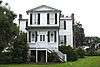
Emanuel Alston House |
|
October 6, 1988
(#88001723) |
Secondary Road 161, 0.25 miles north of its junction with U.S. Route 21
32°24′11″N 80°33′32″W / 32.403056°N 80.558889°W / 32.403056; -80.558889 (Emanuel Alston House) |
Frogmore |
|
| 2 |
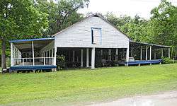
Altamaha Town |
|
January 21, 1994
(#93001479) |
Address Restricted
|
Bluffton |
|
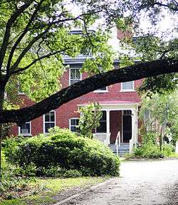
| 3 |
The Anchorage |
|
November 23, 1971
(#71000743) |
1103 Bay St.
32°25′56″N 80°40′27″W / 32.432222°N 80.674167°W / 32.432222; -80.674167 (The Anchorage) |
Beaufort |
|
| 4 |
Dr. York Bailey House |
|
October 6, 1988
(#88001726) |
U.S. Route 21, approximately 0.2 miles east of its junction with Lands End Rd.
32°23′52″N 80°34′27″W / 32.397778°N 80.574167°W / 32.397778; -80.574167 (Dr. York Bailey House) |
Frogmore |
|
| 5 |
William Barnwell House |
|
March 24, 1971
(#71000744) |
800 Prince St.
32°26′06″N 80°40′21″W / 32.435°N 80.6725°W / 32.435; -80.6725 (William Barnwell House) |
Beaufort |
|
| 6 |
Barnwell-Gough House |
|
November 15, 1972
(#72001191) |
705 Washington St.
32°26′13″N 80°40′21″W / 32.436944°N 80.6725°W / 32.436944; -80.6725 (Barnwell-Gough House) |
Beaufort |
|
| 7 |
Beaufort Historic District |
|
December 17, 1969
(#69000159) |
Bounded by the Beaufort River and Bladen, Hamar, and Boundary Sts.
32°26′08″N 80°40′04″W / 32.435556°N 80.667778°W / 32.435556; -80.667778 (Beaufort Historic District) |
Beaufort |
|
| 8 |
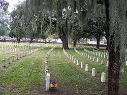
Beaufort National Cemetery |
|
October 10, 1997
(#97001208) |
1601 Boundary St.
32°25′55″N 80°40′49″W / 32.431944°N 80.680278°W / 32.431944; -80.680278 (Beaufort National Cemetery) |
Beaufort |
|
| 9 |
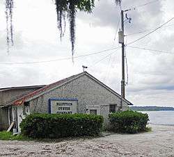
Bluffton Historic District |
|
June 21, 1996
(#96000686) |
Roughly bounded by the May River, Huger Cove, and Bridge St.
32°13′57″N 80°51′49″W / 32.2325°N 80.863611°W / 32.2325; -80.863611 (Bluffton Historic District) |
Bluffton |
|
| 10 |
Callawassie Sugar Works |
|
May 27, 2014
(#13001096) |
29 Sugar Mill Dr.
32°20′08″N 80°51′26″W / 32.3355067°N 80.8571007°W / 32.3355067; -80.8571007 (Callawassie Sugar Works) |
Okatie |
|
| 11 |
Camp Saxton Site |
|
February 2, 1995
(#94001581) |
Address Restricted
|
Port Royal |
|
| 12 |
Charlesfort-Santa Elena Site |
|
August 7, 1974
(#74001822) |
South end of Belleau Wood Road
32°18′23″N 80°40′32″W / 32.3064°N 80.6756°W / 32.3064; -80.6756 (Charlesfort-Santa Elena Site) |
Parris Island |
|
| 13 |
Cherry Hill School |
|
November 21, 2012
(#12000965) |
210 Dillon Rd.
32°14′05″N 80°41′28″W / 32.234748°N 80.691172°W / 32.234748; -80.691172 (Cherry Hill School) |
Hilton Head Island |
|
| 14 |
Chester Field |
|
October 15, 1970
(#70000565) |
Address Restricted
|
Laurel Bay |
|
| 15 |
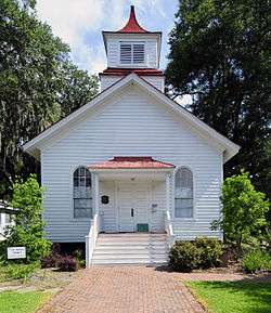
Church of the Cross |
|
May 29, 1975
(#75001686) |
Calhoun St.
32°13′52″N 80°51′52″W / 32.231111°N 80.864444°W / 32.231111; -80.864444 (Church of the Cross) |
Bluffton |
|
| 16 |
Coffin Point Plantation |
|
August 28, 1975
(#75001687) |
3 miles east of Frogmore at the northeastern end of Seaside Rd. on St. Helena Island
32°25′58″N 80°28′32″W / 32.432778°N 80.475556°W / 32.432778; -80.475556 (Coffin Point Plantation) |
Frogmore |
|
| 17 |
Coffin Point Plantation Caretaker's House |
|
May 28, 1989
(#88001730) |
Adjacent to Coffin Point Plantation, off Seaside Rd.
32°26′08″N 80°28′24″W / 32.435556°N 80.473333°W / 32.435556; -80.473333 (Coffin Point Plantation Caretaker's House) |
Frogmore |
|
| 18 |
The Corner Packing Shed |
|
October 6, 1988
(#88001733) |
U.S. Route 21, west of its junction with Land's End Rd.
32°23′51″N 80°34′34″W / 32.3975°N 80.576111°W / 32.3975; -80.576111 (The Corner Packing Shed) |
Frogmore |
|
| 19 |
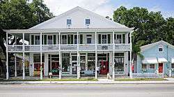
The Corner Store and Office |
|
October 6, 1988
(#88001737) |
U.S. Route 21, west of its junction with Lands End Rd.
32°23′48″N 80°34′43″W / 32.396667°N 80.578611°W / 32.396667; -80.578611 (The Corner Store and Office) |
Frogmore |
|
| 20 |
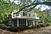
John A. Cuthbert House |
|
June 13, 1972
(#72001192) |
1203 Bay St.
32°25′57″N 80°40′32″W / 32.4325°N 80.675556°W / 32.4325; -80.675556 (John A. Cuthbert House) |
Beaufort |
|
| 21 |
Daufuskie Island Historic District |
|
June 2, 1982
(#82003831) |
Southwest of Hilton Head
32°06′47″N 80°51′59″W / 32.113056°N 80.866389°W / 32.113056; -80.866389 (Daufuskie Island Historic District) |
Hilton Head Island |
|
| 22 |
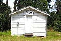
Eddings Point Community Praise House |
|
May 19, 1989
(#88001739) |
On Secondary Road 183, 0.1 miles north of its junction with Secondary Road 74
32°26′36″N 80°32′38″W / 32.443333°N 80.543889°W / 32.443333; -80.543889 (Eddings Point Community Praise House) |
Frogmore |
|
| 23 |
Fish Haul Archaeological Site (38BU805) |
|
June 30, 1988
(#88000976) |
Address Restricted
|
Hilton Head Island |
|
| 24 |
Fort Frederick |
|
December 31, 1974
(#74001826) |
Address Restricted
|
Port Royal |
The preserve is located on the grounds of the Beaufort Naval Hospital. Public access is not permitted except for pre-arranged tours through the South Carolina Department of Natural Resources. |
| 25 |
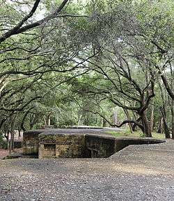
Fort Fremont Battery |
|
May 5, 2010
(#88001821) |
Bay Point Rd., 0.3 miles (0.48 km) from Land's End Rd.
32°18′22″N 80°38′32″W / 32.306111°N 80.642222°W / 32.306111; -80.642222 (Fort Fremont Battery) |
Frogmore |
|
| 26 |
Fort Fremont Hospital |
|
May 26, 1989
(#88001819) |
0.3 miles from Land's End Rd.
32°18′29″N 80°38′37″W / 32.308056°N 80.643611°W / 32.308056; -80.643611 (Fort Fremont Hospital) |
Frogmore |
|
| 27 |
Fort Howell |
|
June 15, 2011
(#11000371) |
North side of Beach City Rd. approximately 200 ft. southwest of the junction with Dillon Rd.
32°14′04″N 80°41′31″W / 32.234444°N 80.691944°W / 32.234444; -80.691944 (Fort Howell) |
Hilton Head |
Civil War earthwork fortification built in 1864 by the 32nd United States Colored Infantry Regiment and the 144th New York Infantry[6] |
| 28 |
Fort Lyttelton Site |
|
September 13, 1979
(#79003322) |
Address Restricted
|
Beaufort |
|
| 29 |
Fort Mitchell |
|
June 5, 2017
(#100001036) |
65 Skull Creek Dr.
32°14′36″N 80°44′37″W / 32.243392°N 80.743734°W / 32.243392; -80.743734 (Fort Mitchell) |
Hilton Head |
|
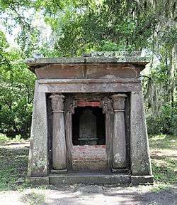
| 30 |
Edgar Fripp Mausoleum, St. Helena Island Parish Church |
|
October 6, 1988
(#88001743) |
Secondary Road 45 near its junction with Secondary Road 37
32°22′30″N 80°34′34″W / 32.375°N 80.576111°W / 32.375; -80.576111 (Edgar Fripp Mausoleum, St. Helena Island Parish Church) |
Frogmore |
|
| 31 |
Isaac Fripp House Ruins |
|
October 6, 1988
(#88001750) |
On an unpaved road, 1.1 miles west of its junction with Secondary Road 45
32°20′37″N 80°38′25″W / 32.343611°N 80.640278°W / 32.343611; -80.640278 (Isaac Fripp House Ruins) |
Frogmore |
|
| 32 |
Frogmore Plantation Complex |
|
May 26, 1989
(#88001754) |
Off Secondary Road 77 near its junction with Secondary Road 35
32°21′32″N 80°33′40″W / 32.358889°N 80.561111°W / 32.358889; -80.561111 (Frogmore Plantation Complex) |
Frogmore |
|
| 33 |
Green's Shell Enclosure |
|
August 7, 1974
(#74001825) |
Address Restricted
|
Hilton Head Island |
|
| 34 |
The Green |
|
October 6, 1988
(#88001759) |
Southeastern corner of the intersection of U.S. Route 21 and Lands End Rd.
32°23′46″N 80°34′37″W / 32.396111°N 80.576944°W / 32.396111; -80.576944 (The Green) |
Frogmore |
|
| 35 |
Hasell Point Site |
|
August 14, 1973
(#73001675) |
Address Restricted
|
Port Royal |
|
| 36 |
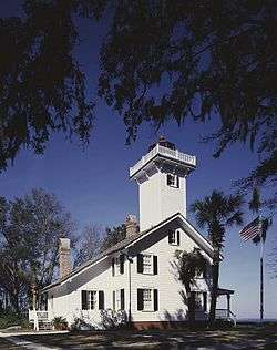
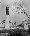
Hunting Island State Park Lighthouse |
|
June 5, 1970
(#70000561) |
17 miles south-southeast of Beaufort on U.S. Route 21
32°22′32″N 80°26′16″W / 32.375556°N 80.437778°W / 32.375556; -80.437778 (Hunting Island State Park Lighthouse) |
Beaufort |
|
| 37 |
Indian Hill Site |
|
March 22, 1974
(#74001827) |
Address Restricted
|
St. Helena Island |
|
| 38 |
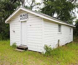
Mary Jenkins Community Praise House |
|
May 19, 1989
(#88001770) |
On Secondary Road 74, 2.1 miles north of its junction with U.S. Route 21
32°25′47″N 80°33′38″W / 32.429722°N 80.560556°W / 32.429722; -80.560556 (Mary Jenkins Community Praise House) |
Frogmore |
|
| 39 |
Knights of Wise Men Lodge |
|
April 12, 1996
(#96000408) |
Martin Luther King Dr., south of its junction with U.S. Route 21
32°23′43″N 80°33′58″W / 32.395278°N 80.566111°W / 32.395278; -80.566111 (Knights of Wise Men Lodge) |
St. Helena Island |
|
| 40 |
Lands End Road Tabby Ruins |
|
October 6, 1988
(#88001771) |
Address Restricted
|
Frogmore |
|
| 41 |
Laurel Bay Plantation |
|
February 27, 1997
(#97000095) |
Address Restricted
|
Beaufort |
|
| 42 |
Little Barnwell Island |
|
August 14, 1973
(#73001676) |
North of Port Royal
32°30′06″N 80°47′25″W / 32.501667°N 80.790278°W / 32.501667; -80.790278 (Little Barnwell Island) |
Port Royal |
|
| 43 |
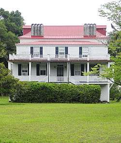
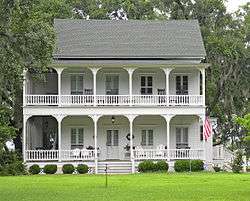
Marshlands |
|
November 7, 1973
(#73001674) |
501 Pinckney St.
32°25′59″N 80°39′56″W / 32.433056°N 80.665556°W / 32.433056; -80.665556 (Marshlands) |
Beaufort |
|
| 44 |
McLeod Farmstead |
|
July 25, 1997
(#97000776) |
Seabrook Rd., 1 mile west of U.S. Route 21 and 10 miles north of Beaufort
32°31′40″N 80°45′56″W / 32.527778°N 80.765556°W / 32.527778; -80.765556 (McLeod Farmstead) |
Seabrook |
|
| 45 |
The Oaks |
|
October 6, 1988
(#88001773) |
On an unpaved road, 0.3 miles west of Secondary Road 165
32°23′21″N 80°37′12″W / 32.389167°N 80.62°W / 32.389167; -80.62 (The Oaks) |
Frogmore |
|
| 46 |
Old Brass |
|
June 3, 1976
(#76001693) |
East of Yemassee on River Rd.
32°41′00″N 80°48′30″W / 32.683333°N 80.808333°W / 32.683333; -80.808333 (Old Brass) |
Yemassee |
|
| 47 |
Orange Grove Plantation |
|
May 26, 1989
(#88001774) |
Overlooking Wallace Creek, 0.25 mi. from South Carolina Highway 113
32°22′13″N 80°36′14″W / 32.370278°N 80.603889°W / 32.370278; -80.603889 (Orange Grove Plantation) |
Frogmore |
|
| 48 |
Parris Island Drydock and Commanding Generals House |
|
November 21, 1978
(#78002492) |
Mexico and Tripoli Sts.
32°21′00″N 80°40′18″W / 32.35°N 80.671667°W / 32.35; -80.671667 (Parris Island Drydock and Commanding Generals House) |
Parris Island |
|
| 49 |
Penn Center Historic District |
|
September 9, 1974
(#74001824) |
South of Frogmore on South Carolina Highway 37
32°23′16″N 80°34′44″W / 32.387778°N 80.578889°W / 32.387778; -80.578889 (Penn Center Historic District) |
Frogmore |
|
| 50 |
Pine Island Plantation Complex |
|
May 26, 1989
(#88001775) |
Pine Island
32°26′25″N 80°30′38″W / 32.440278°N 80.510556°W / 32.440278; -80.510556 (Pine Island Plantation Complex) |
Frogmore |
|
| 51 |
Pocosobo Town |
|
January 21, 1994
(#93001480) |
Address Restricted
|
Sheldon |
|
| 52 |
Port Royal School |
|
April 21, 2014
(#14000163) |
1214 Paris Ave.
32°22′40″N 80°41′30″W / 32.377911°N 80.69171°W / 32.377911; -80.69171 (Port Royal School) |
Port Royal |
|
| 53 |
Rear Lighthouse of Hilton Head Range Light Station |
|
December 12, 1985
(#85003349) |
Arthur Hill Golf Course, Palmetto Dunes Resort off U.S. Route 278
32°09′51″N 80°44′24″W / 32.164167°N 80.74°W / 32.164167; -80.74 (Rear Lighthouse of Hilton Head Range Light Station) |
Hilton Head Island |
|
| 54 |
Riverside Plantation Tabby Ruins |
|
October 6, 1988
(#88001776) |
On an unpaved road., 0.4 miles west of Secondary Road 45 at Lands End
32°18′57″N 80°38′38″W / 32.315833°N 80.643889°W / 32.315833; -80.643889 (Riverside Plantation Tabby Ruins) |
Frogmore |
|
| 55 |
Rose Hill Plantation House |
|
May 19, 1983
(#83002185) |
Off U.S. Route 278
32°17′42″N 80°52′31″W / 32.295°N 80.875278°W / 32.295; -80.875278 (Rose Hill Plantation House) |
Bluffton |
|
| 56 |
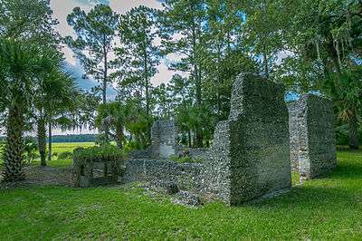
St. Helena Parish Chapel of Ease Ruins |
|
October 6, 1988
(#88001777) |
Secondary Road 45, near its junction with Secondary Road 37
32°22′31″N 80°34′36″W / 32.375278°N 80.576667°W / 32.375278; -80.576667 (St. Helena Parish Chapel of Ease Ruins) |
Frogmore |
|
| 57 |
St. Helenaville Archaeological Site (38BU931) |
|
October 6, 1988
(#88001778) |
Address Restricted
|
Frogmore |
|
| 58 |
St. Luke's Church |
|
November 10, 1987
(#87001951) |
South Carolina Highway 170
32°16′24″N 80°57′00″W / 32.273333°N 80.95°W / 32.273333; -80.95 (St. Luke's Church) |
Pritchardville |
|
| 59 |
St. Luke's Parish Zion Chapel of Ease Cemetery |
|
October 5, 2017
(#100000727) |
574 William Hilton Pkwy.
32°12′06″N 80°41′57″W / 32.201573°N 80.699233°W / 32.201573; -80.699233 (St. Luke's Parish Zion Chapel of Ease Cemetery) |
Hilton Head Island |
|
| 60 |
Sams Plantation Complex Tabby Ruins |
|
March 4, 2011
(#88001820) |
Southern end of Dataw (Datha) Island near the intersection of Dataw Dr. and Dataw Club Rd., at Mink's Point near Jenkins Creek
32°25′51″N 80°35′04″W / 32.430833°N 80.584444°W / 32.430833; -80.584444 (Sams Plantation Complex Tabby Ruins) |
Frogmore |
Ruins of late-18th/early-19th century tabby plantation complex; originally listed as "Sams Tabby Complex (38BU581)"[7] |
| 61 |
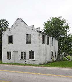
F.W. Scheper Store |
|
June 22, 2004
(#04000652) |
918 8th St.
32°22′29″N 80°41′34″W / 32.374722°N 80.692778°W / 32.374722; -80.692778 (F.W. Scheper Store) |
Port Royal |
|
| 62 |
Sea Pines |
|
October 15, 1970
(#70000563) |
Address Restricted
|
Hilton Head Island |
A prehistoric shell midden on Hilton Head Island. |
| 63 |
Seacoast Packing Company |
|
June 17, 2008
(#08000537) |
100 Dill Dr.
32°25′24″N 80°41′33″W / 32.4233°N 80.6926°W / 32.4233; -80.6926 (Seacoast Packing Company) |
Beaufort |
|
| 64 |
Seaside Plantation |
|
July 16, 1979
(#79002375) |
10 miles east of Beaufort on U.S. Route 21
32°21′02″N 80°34′13″W / 32.350556°N 80.570278°W / 32.350556; -80.570278 (Seaside Plantation) |
Beaufort |
|
| 65 |
Sheldon Church Ruins |
|
October 22, 1970
(#70000562) |
Northwest of Gardens Corner on Old Sheldon Church Road
32°37′07″N 80°46′50″W / 32.618528°N 80.780472°W / 32.618528; -80.780472 (Sheldon Church Ruins) |
Gardens Corner |
|
| 66 |
Robert Simmons House |
|
October 6, 1988
(#88001779) |
On an unpaved road, 0.5 miles south of U.S. Route 21
32°23′29″N 80°36′15″W / 32.391389°N 80.604167°W / 32.391389; -80.604167 (Robert Simmons House) |
Frogmore |
|
| 67 |
Skull Creek |
|
November 10, 1970
(#70000564) |
Address Restricted
|
Hilton Head Island |
|
| 68 |
Robert Smalls House |
|
May 30, 1974
(#74001823) |
511 Prince St.
32°26′07″N 80°40′06″W / 32.435278°N 80.668333°W / 32.435278; -80.668333 (Robert Smalls House) |
Beaufort |
|
| 69 |
SS WILLIAM LAWRENCE Shipwreck Site |
|
February 10, 1998
(#97000522) |
Address Restricted
|
Hilton Head Island |
|
| 70 |
Stoney-Baynard Plantation |
|
February 23, 1994
(#94000038) |
Junction of Baynard Park Rd. and Plantation Dr.
32°07′44″N 80°48′53″W / 32.128889°N 80.814722°W / 32.128889; -80.814722 (Stoney-Baynard Plantation) |
Hilton Head Island |
|
| 71 |
Tabby Manse |
|
May 14, 1971
(#71000745) |
1211 Bay St.
32°25′58″N 80°40′35″W / 32.432778°N 80.676389°W / 32.432778; -80.676389 (Tabby Manse) |
Beaufort |
|
| 72 |
Tombee Plantation |
|
September 18, 1975
(#75001688) |
South of Frogmore on St. Helena's Island
32°18′31″N 80°37′25″W / 32.308611°N 80.623611°W / 32.308611; -80.623611 (Tombee Plantation) |
Frogmore |
|
| 73 |
Union Church of Port Royal |
|
November 17, 2010
(#10000931) |
1004 11th St.
32°22′37″N 80°41′35″W / 32.376944°N 80.693056°W / 32.376944; -80.693056 (Union Church of Port Royal) |
Port Royal |
|
| 74 |
John Mark Verdier House |
|
August 19, 1971
(#71000746) |
801 Bay St.
32°25′50″N 80°40′16″W / 32.430556°N 80.671111°W / 32.430556; -80.671111 (John Mark Verdier House) |
Beaufort |
|
.jpg)
.jpg)
.jpg)
.jpg)
.jpg)
.jpg)
.jpg)
.jpg)
.jpg)
%2C_Sheldon_vicinity_(Beaufort_County%2C_South_Carolina).jpg)
.jpg)
.jpg)
.jpg)