Port Royal Island
Port Royal Island (historically Port Royal) is an island located in Beaufort County, South Carolina. It is considered one of Sea Islands in the Lowcountry region and is the most populous island in northern Beaufort County, containing most of the incorporated areas of Beaufort, Port Royal, and other unincorporated communities. The island also contains the Marine Corps Air Station Beaufort and Naval Hospital Beaufort military installations. The island takes its name from the Port Royal Sound, a historically significant harbor during colonial settlement in the 16th, 17th, and 18th centuries. From the time of its European discovery to the late 19th century, the name "Port Royal" typically applied to Port Royal Island as a whole and the surrounding waterways. In the early 21st century, the term Port Royal is understood to apply to the incorporated town of Port Royal.
History
In 1562, the French settlement of Charlesfort was established on Parris Island. The leader of the settlement was Jean Ribault, who referred to the name of the sound and the island as Port Royal, or royal port in French. After the Charlesfort settlement failed, the Spanish attempted to establish their own Santa Elena settlement in 1566, a name that is used to this day for nearby St. Helena Island.[1] Later, during the English colonization of Carolina, the English adopted the name Port Royal for the sound and for the island itself once their colonization efforts began, with the establishment of Charles Town in 1670.
In 1779 the Battle of Beaufort was fought on the island between American and British forces, resulting in an American victory. In 1861, the Battle of Port Royal was fought between Union and Confederate forces, resulting in a Union victory and the occupation of Beaufort for the remainder of the Civil War.
Historically, the island has been predominantly agricultural and had been developed as plantations in the antebellum years. Since the 1960s, the island has become mostly residential and commercial in character, though rural areas continue to exist in the extreme northern and western portions of the island along the Whale Branch River.
Communities
References
- ↑ "Charlesfort-Santa Elena". National Historic Landmark, American Latino Heritage Sites. National Park Service. Archived from the original on February 21, 2018. Retrieved August 9, 2018.
Coordinates: 32°26′08″N 80°44′19″W / 32.43556°N 80.73861°W
The Lowcountry of South Carolina | ||
|---|---|---|
| Counties | 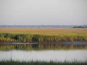 | |
| Major communities | ||
| Sea Islands | ||
| History & culture | ||
| Military installations | ||
| Natural areas | ||
| Other articles | ||
Municipalities and communities of Beaufort County, South Carolina, United States | ||
|---|---|---|
| Cities | 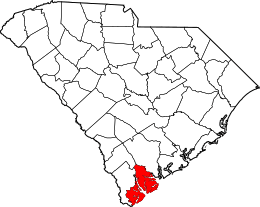 | |
| Towns | ||
| CDPs | ||
| Unincorporated communities | ||
| Footnotes | ‡This populated place also has portions in an adjacent county or counties | |