Nasiksthan Sanga
| Nasiksthan Sanga नासिकास्थान साँगा hindu temple nasikasthan | |
|---|---|
| (Nepal)Banepa municipality | |
| Nickname(s): बनेपा नगरपालिका,१३,१४ | |
 Nasiksthan Sanga Location in Nepal | |
| Coordinates: 27°38′06″N 85°28′55″E / 27.635°N 85.482°ECoordinates: 27°38′06″N 85°28′55″E / 27.635°N 85.482°E | |
| Country | Nepal |
| Zone | Bagmati Zone |
| District | Kabhrepalanchok District |
| Population (2011) | |
| • Total | 6,121 |
| Time zone | UTC+5:45 (Nepal Time) |
| Area code(s) | 011 |
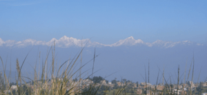
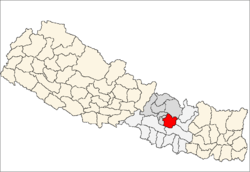
Nasiksthan Sanga is a part of Banepa Municipality in Kabhrepalanchok District in the Bagmati Zone of central Nepal. At the time of the 2011 Nepal census it had a population of 6121 in 1305 individual households. [1]
Place of attraction
- Nasikasthan temple
- Bikateswor temple
- Ashapureswor temple
- Kailashnath temple
References
- ↑ "Nepal Census 2001". Nepal'sबनेपा नगर पालिका,१३,१४. Digital Himalaya. Retrieved 2008-09-03.
External links
This article is issued from
Wikipedia.
The text is licensed under Creative Commons - Attribution - Sharealike.
Additional terms may apply for the media files.