Mathurapati Fulbari
| Mathurapati Phulbari मथुरापाटी फूलबारी | |
|---|---|
| Village development committee | |
 Mathurapati (a inn), after which the VDC was named. | |
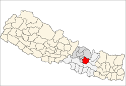
 Mathurapati Phulbari Location in Nepal | |
| Coordinates: 27°35′N 85°37′E / 27.58°N 85.62°ECoordinates: 27°35′N 85°37′E / 27.58°N 85.62°E | |
| Country | Nepal |
| Zone | Bagmati Zone |
| District | Kabhrepalanchok District |
| Population (1991) | |
| • Total | 4,565 |
| Time zone | UTC+5:45 (Nepal Time) |
| Postcode | 45205 A.P.O., Dapcha[1] |
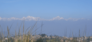
Mathurapati Phulbari is a village development committee in Kabhrepalanchok District in the Bagmati Zone of central Nepal. At the time of the 1991 Nepal census it had a population of 4565. The village is situated 45 km east from capital city Kathmandu. It is situated in the upper belt of the B.P Highway which joins Capital to Eastern Terai in the shortest route. The village has a mixed community including several ethnic groups staying in harmony. The main castes living in Phulbari are Brahmins, Chhetris, Tamangs, Newars and other castes. Nowadays Fulbari VDC is included in Dapcha kashikanda municipality. Fulbari VDC main industry area is Bhakundebesi.[2]
References
- ↑ "Archived copy". Archived from the original on 2011-07-19. Retrieved 2011-05-19.
- ↑ "Nepal Census 2001". Nepal's Village Development Committees. Digital Himalaya. Archived from the original on 2008-10-12. Retrieved 2008-09-03.
External links
This article is issued from
Wikipedia.
The text is licensed under Creative Commons - Attribution - Sharealike.
Additional terms may apply for the media files.