Namtso
| Namtso | |
|---|---|
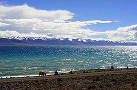
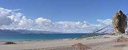 View of the lake and the holy rock near the Tashi Dor monastery (2005) | |
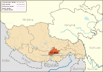
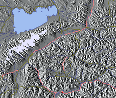 Relief map. Lhasa is the area marked in red at the bottom. | |
| Location | Damxung/Baingoin, Tibet Autonomous Region, Tibet |
| Coordinates | 30°42′N 90°33′E / 30.700°N 90.550°ECoordinates: 30°42′N 90°33′E / 30.700°N 90.550°E |
| Type | salt lake |
| Primary inflows | snow cover and spring of Tanggula Mountains |
| Primary outflows | None (endorheic)[1] |
| Basin countries | People's Republic of China |
| Max. length | 70 km (43 mi) |
| Max. width | 30 km (19 mi) |
| Surface area | 1,920 km2 (740 sq mi) |
| Average depth | 33 m (108 ft) |
| Max. depth | 125 m (410 ft)[2] |
| Water volume | 768 billion cubic metres (623×106 acre⋅ft) |
| Surface elevation | 4,718 m (15,479 ft) |
| Islands | 5 |
| Namtso | |||||||||||
| Tibetan name | |||||||||||
|---|---|---|---|---|---|---|---|---|---|---|---|
| Tibetan | གནམ་མཚོ་ | ||||||||||
| |||||||||||
| Chinese name | |||||||||||
| Traditional Chinese | 納木錯 | ||||||||||
| Simplified Chinese | 纳木错 | ||||||||||
| |||||||||||
Namtso or Lake Nam (officially: Nam Co; Mongolian: Tenger nuur; “Heavenly Lake”; in European literature: Tengri Nor, 30°42′N 90°33′E / 30.700°N 90.550°E) is a mountain lake on the border between Damxung County of Lhasa prefecture-level city and Baingoin County of Nagqu Prefecture in the Tibet Autonomous Region of China, approximately 112 kilometres (70 mi) NNW of Lhasa.
Geography and climate
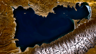
Namtso was born in the Paleogene age, as a result of Himalayan tectonic plate movements. The lake lies at an elevation of 4,718 m (15,479 ft), and has a surface area of 1,920 km2 (740 sq mi). This salt lake is the largest lake in the Tibet Autonomous Region. However, it is not the largest lake on the Qinghai-Tibet Plateau. That title belongs to Qinghai Lake (more than twice the size of Namtso); which lies more than 1,000 km (620 mi) to the north-east in Qinghai.
Namtso has five uninhabited islands of reasonable size, in addition to one or two rocky outcrops. The islands have been used for spiritual retreat by pilgrims who walk over the lake's frozen surface at the end of winter, carrying their food with them. They spend the summer there, unable to return to shore again until the water freezes the following winter. This practice is no longer permitted by Chinese authorities.
The largest of the islands is in the northwest corner of the lake, and is about 2,100 m (6,900 ft) long and 800 m (2,600 ft) wide, rising to just over 100 m (330 ft) in the middle. At its closest point it is about 3.1 km (1.9 mi) from the shore.
The most remote island is, at its closest, 5.1 km (3.2 mi) from the shore. At summer time birds like Ruddy shelduck and cormorants (Phalacrocorax sp.) migrate to the lake area, besides the fields of Astragalus, Roegneria nutans and Marram grass.
The weather at Namtso is subject to abrupt, sudden change and snowstorms are very common across the Nyainqêntanglha range.
Namtso has an alpine tundra climate (Koppen ET).
| Climate data for Namtso | |||||||||||||
|---|---|---|---|---|---|---|---|---|---|---|---|---|---|
| Month | Jan | Feb | Mar | Apr | May | Jun | Jul | Aug | Sep | Oct | Nov | Dec | Year |
| Average high °C (°F) | −3.0 (26.6) |
−1.4 (29.5) |
1.7 (35.1) |
5.6 (42.1) |
10.0 (50) |
14.0 (57.2) |
14.4 (57.9) |
13.4 (56.1) |
11.7 (53.1) |
6.5 (43.7) |
1.4 (34.5) |
−1.7 (28.9) |
6.1 (42.9) |
| Daily mean °C (°F) | −11.8 (10.8) |
−9.6 (14.7) |
−6.1 (21) |
−1.7 (28.9) |
2.9 (37.2) |
7.3 (45.1) |
8.4 (47.1) |
7.7 (45.9) |
5.6 (42.1) |
−0.3 (31.5) |
−6.8 (19.8) |
−10.5 (13.1) |
−1.2 (29.8) |
| Average low °C (°F) | −20.6 (−5.1) |
−17.8 (0) |
−13.8 (7.2) |
−9.0 (15.8) |
−4.2 (24.4) |
0.7 (33.3) |
2.5 (36.5) |
2.1 (35.8) |
−0.4 (31.3) |
−7.1 (19.2) |
−14.9 (5.2) |
−19.3 (−2.7) |
−8.5 (16.7) |
| Average precipitation mm (inches) | 1 (0.04) |
1 (0.04) |
1 (0.04) |
4 (0.16) |
14 (0.55) |
51 (2.01) |
87 (3.43) |
87 (3.43) |
48 (1.89) |
10 (0.39) |
2 (0.08) |
1 (0.04) |
307 (12.1) |
| Source: Climate-Data.org | |||||||||||||
Other Features
Namtso is renowned as one of the most beautiful places in the Nyainqêntanglha mountain range. Its cave hermitages have for centuries been the destination of Tibetan pilgrims. A surfaced road across Laken Pass at 5186 m was completed to the lake in 2005, enabling easy access from Lhasa and the development of tourism at the lake. Settlements in the area include Dobjoi, Donggar and Cha'gyungoinba. The Tashi Dor monastery is located at the southeastern corner of the lake.
Around the area's natural elements, historical and anthropological background, a 2010 romantic drama 香格里拉 Shangri-La, starring China's popular actor Hu Ge, was broadcast at CCTV1 and received positive reviews.[3] Some scenes in the 2002 Hong Kong film The Touch were filmed at the lake. Namtso Lake was featured in the BBC TV series: Himalaya with Michael Palin.
|
See also
- Laken Pass (Lakenla)
- Kanas Lake
References
External links
| Wikimedia Commons has media related to Namtso. |
| Five Great Lakes | ||
|---|---|---|
| Notable freshwater lakes |
| |
| Notable salt lakes | ||
| National Parks |
| |
| Protected wetlands | ||
| Nature Reserves | ||
| Major urban lakes | ||
| Reservoirs |
| |