Na Yong District
| Na Yong นาโยง | |
|---|---|
| Amphoe | |
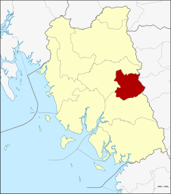 Amphoe location in Trang Province | |
| Coordinates: 7°33′42″N 99°41′42″E / 7.56167°N 99.69500°ECoordinates: 7°33′42″N 99°41′42″E / 7.56167°N 99.69500°E | |
| Country | Thailand |
| Province | Trang |
| Seat | Na Yong Nuea |
| Area | |
| • Total | 165.1 km2 (63.7 sq mi) |
| Population (2005) | |
| • Total | 42,294 |
| • Density | 256.2/km2 (664/sq mi) |
| Time zone | UTC+7 (ICT) |
| Postal code | 92170 |
| Geocode | 9208 |
Na Yong (Thai: นาโยง, pronounced [nāː jōːŋ]) is a district (amphoe) of Trang Province, Thailand.
History
The minor district (king amphoe) Na Yong was established on 1 April 1990 by splitting off six tambons from Mueang Trang District.[1] It was upgraded to a full district on 4 November 1993.[2]
Geography
Neighboring districts are (from the south clockwise) Yan Ta Khao and Mueang Trang of Trang Province, Si Banphot and Srinagarindra of Phatthalung Province.
Administration
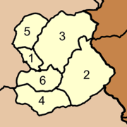
The district is divided into six sub-districts (tambon), which are further subdivided into 53 villages (muban). Na Yong Nuea is a township (thesaban tambon) which covers parts of tambon Na Yong Nuea. There are a further six tambon administrative organizations (TAO).
|
 |
References
- ↑ ประกาศกระทรวงมหาดไทย เรื่อง แบ่งเขตท้องที่อำเภอเมืองตรัง จังหวัดตรัง ตั้งเป็นกิ่งอำเภอนาโยง (PDF). Royal Gazette (in Thai). 107 (25 ง): 1350. February 13, 1990.
- ↑ พระราชกฤษฎีกาตั้งอำเภอลำทับ อำเภอร่องคำ อำเภอเวียงแหง อำเภอนาโยง อำเภอแก้งสนามนาง อำเภอโนนแดง อำเภอบ้านหลวง อำเภอกะพ้อ อำเภอศรีบรรพต อำเภอแก่งกระจาน อำเภอหนองสูง อำเภอสบเมย อำเภอเมยวดี อำเภอโคกเจริญ อำเภอทุ่งหัวช้าง อำเภอผาขาว อำเภอวังหิน อำเภอดอนพุด อำเภอบึงโขงหลง และอำเภอห้วยคต พ.ศ. ๒๕๓๖ (PDF). Royal Gazette (in Thai). 110 (179 ก special): 1–3. November 3, 1993.
External links
This article is issued from
Wikipedia.
The text is licensed under Creative Commons - Attribution - Sharealike.
Additional terms may apply for the media files.