Sikao District
| Sikao สิเกา | |
|---|---|
| Amphoe | |
 | |
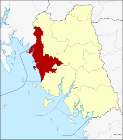 Amphoe location in Trang Province | |
| Coordinates: 7°34′18″N 99°20′42″E / 7.57167°N 99.34500°ECoordinates: 7°34′18″N 99°20′42″E / 7.57167°N 99.34500°E | |
| Country | Thailand |
| Province | Trang |
| Seat | Bo Hin |
| Area | |
| • Total | 524.0 km2 (202.3 sq mi) |
| Population (2005) | |
| • Total | 34,486 |
| • Density | 63.6/km2 (165/sq mi) |
| Time zone | UTC+7 (ICT) |
| Postal code | 92150 |
| Geocode | 9205 |
Sikao (Thai: สิเกา, pronounced [sìʔ.kāw]) is a district (amphoe) in the northwestern part of Trang Province, Thailand.
History
Sikao District was established in 1887. The present district office was opened 1 March 1987. Sikao District administrative office is in Bohin Sub-district (Sikao townships)
Geography
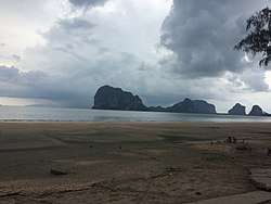
Neighboring districts are (from the northwest clockwise) Khlong Thom of Krabi Province, Wang Wiset, Mueang Trang, and Kantang of Trang Province. To the west is the Andaman Sea.
Administration
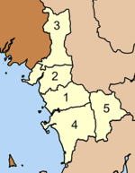
The district is divided into five sub-districts (tambon), which are further subdivided into 40 villages (muban). There are two townships (thesaban tambon). Sikao covers parts of tambon Bo Hin, and Khuan Kun covers parts of Kalase. There are a further five tambon administrative organizations (TAO).
|
 |
Economy
Sikao is the one of the proposed entrances to the Thai Canal. It is designated as Route 9A. The canal would connect to the Gulf of Thailand, 135 km to the east.[1]
References
- ↑ Voytenko, Mikhail (2018-02-18). "Thailand Merchant Marine can play a bigger role". Maritime Bulletin. Retrieved 20 February 2018.
External links