Muzhakkunnu
| Muzhakkunnu Mizhavu Kunnu | |
|---|---|
| village | |
 Muzhakkunnu Bhagavathy Temple | |
| Coordinates: 11°57′10″N 75°40′10″E / 11.95278°N 75.66944°ECoordinates: 11°57′10″N 75°40′10″E / 11.95278°N 75.66944°E | |
| Country |
|
| State | Kerala |
| District | Kannur |
| Government | |
| • Body | Gram panchayat |
| Population (2001) | |
| • Total | 21,117 |
| Languages | |
| • Official | Malayalam, English |
| Time zone | UTC+5:30 (IST) |
| PIN | 670673 |
| Telephone code | 0490 |
| ISO 3166 code | IN-KL |
| Vehicle registration | KL 13,58 |
| Nearest city | Iritty |
| Lok Sabha constituency | Kannur |
| Vidhan Sabha constituency | Peravoor |
| Climate | cool (Köppen) |
Muzhakkunnu is a village in Kannur district in the Indian state of Kerala.[1]
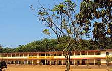
Pala School, Muzhakkunnu
Location
Muzhakkunnu is a historic village in kannur district near Iritty.
Temples
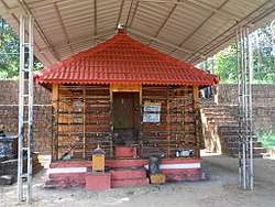
Muzhakkunnu has a temple by the name Mridanga Saileswari Temple. It has a pancha loha idol inside.
Transportation
The national highway passes through Thalassery town. Mangalore and Mumbai can be accessed on the northern side and Cochin and Thiruvananthapuram can be accessed on the southern side. The road to the east of Iritty connects to Mysore and Bangalore. The nearest railway station is Thalassery railway station on Mangalore-Palakkad line. There are airports at Mangalore and Calicut.
References
| Wikivoyage has a travel guide for Muzhakkunnu. |
- ↑ "Census of India : Villages with population 5000 & above". Registrar General & Census Commissioner, India. Retrieved 2008-12-10.
This article is issued from
Wikipedia.
The text is licensed under Creative Commons - Attribution - Sharealike.
Additional terms may apply for the media files.