Irapuato
| Irapuato | |||
|---|---|---|---|
| City and municipality | |||
 Catedral de Nuestra Señora de la Soledad | |||
| |||
|
Nickname(s): Spanish: Ciudad de las Fresas (English: City of the strawberries) | |||
|
Motto(s): Latin: Ad Augusta Per Angusta (English: To honors through difficulties) | |||
 Location of Irapuato in Mexico | |||
| Coordinates: 20°40′N 101°21′W / 20.667°N 101.350°WCoordinates: 20°40′N 101°21′W / 20.667°N 101.350°W | |||
| Country |
| ||
| State |
| ||
| Municipality |
| ||
| Founded | February 15, 1547 | ||
| Founded as | Congregación de San Marcos Irapuato | ||
| Founded by | Vasco de Quiroga[1] | ||
| Government | |||
| • Municipal President | Ricardo Ortiz Gutiérrez | ||
| Area | |||
| • Total | 845.16 km2 (326.32 sq mi) | ||
| Elevation | 1,724 m (5 676 ft) | ||
| Population (2010) | |||
| • Total | 380,941 city; 529,440 municipality | ||
| • Density | 626.44/km2 (1,622.5/sq mi) | ||
| Demonym(s) | Irapuatense, Fresero | ||
| Time zone | UTC-6 (Central Standard Time) | ||
| • Summer (DST) | UTC-5 (Central Daylight Time) | ||
| ZIP code | 36590 - 36899 | ||
| Area code(s) | 462 | ||
| Website | Official Website of the City of Irapuato | ||
| Average temperature 19°C | |||


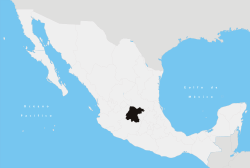
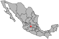
Irapuato is a Mexican town (and municipality) located at the foot of the Arandas Hill (in Spanish: Cerro de Arandas), in the south central region of the state of Guanajuato. It lies between the Silao River and the Guanajuato River, a tributary of the Lerma River, at 1,724 m (5,656 ft) above sea level. It is located at 20°40′N 101°21′W / 20.667°N 101.350°W. The city is the second-largest in the state (only behind León), with a population of 342,561 according to the 2005 census, while its municipality has a population of 529,440.[2] The municipality has an area of 845.16 km² (326.32 sq mi) and includes numerous smaller outlying communities. The city's main industry is agriculture and it is famous for its strawberries and the raising of pigs and cattle. The fruits and flowers of Irapuato's luxurious gardens are well known throughout Mexico.[3]
History
Prehispanic era
In the pre-Hispanic era, the site was inhabited by the Chichimecas (c. 1200 AD), a group of semi-nomadic hunter-gatherers. Later on, the Purépechas conquered the region and initiated the establishment of a permanent settlement. They constructed buildings in the Purépecha architectural style, produced pottery, and practiced agriculture. They called the settlement Xiriquitzio (or Iriquitzio), which the Spanish conquerors pronounced "Jiricuato" (or Jiricuicho), which meant "the place with houses (or low dwellings)".[4] The initial growth period, however, was short lived. The downfall of the Purépecha Empire led to the abandonment of the settlement, at which point it was once again inhabited by the Chichimecas.
Conquest
In the 16th century, vasts amounts of silver ore were discovered at the present day site of the capital city of Guanajuato. This discovery led to a massive migration of Spanish settlers to the area.[5]
Climate
It has a temperate climate 19°C (67°F) with rains in summer at an altitude above sea level 1724 meters (5676 ft)
| Climate data for Irapuato | |||||||||||||
|---|---|---|---|---|---|---|---|---|---|---|---|---|---|
| Month | Jan | Feb | Mar | Apr | May | Jun | Jul | Aug | Sep | Oct | Nov | Dec | Year |
| Record high °C (°F) | 31.0 (87.8) |
35.0 (95) |
35.0 (95) |
38.0 (100.4) |
42.1 (107.8) |
38.0 (100.4) |
35.0 (95) |
32.0 (89.6) |
34.0 (93.2) |
33.5 (92.3) |
33.0 (91.4) |
32.0 (89.6) |
42.1 (107.8) |
| Average high °C (°F) | 24.4 (75.9) |
26.3 (79.3) |
29.1 (84.4) |
31.1 (88) |
32.3 (90.1) |
30.2 (86.4) |
28.2 (82.8) |
28.0 (82.4) |
27.5 (81.5) |
27.1 (80.8) |
26.3 (79.3) |
24.9 (76.8) |
28.0 (82.4) |
| Daily mean °C (°F) | 15.2 (59.4) |
16.7 (62.1) |
19.4 (66.9) |
21.8 (71.2) |
23.7 (74.7) |
23.2 (73.8) |
21.6 (70.9) |
21.4 (70.5) |
20.9 (69.6) |
19.5 (67.1) |
17.5 (63.5) |
15.9 (60.6) |
19.7 (67.5) |
| Average low °C (°F) | 6.0 (42.8) |
7.1 (44.8) |
9.6 (49.3) |
12.5 (54.5) |
15.1 (59.2) |
16.1 (61) |
15.1 (59.2) |
14.9 (58.8) |
14.3 (57.7) |
11.8 (53.2) |
8.7 (47.7) |
6.9 (44.4) |
11.5 (52.7) |
| Record low °C (°F) | −3.0 (26.6) |
−2.5 (27.5) |
0.0 (32) |
4.0 (39.2) |
5.0 (41) |
10.0 (50) |
6.5 (43.7) |
9.0 (48.2) |
4.8 (40.6) |
2.0 (35.6) |
0.0 (32) |
−2.0 (28.4) |
−3 (26.6) |
| Average precipitation mm (inches) | 11.5 (0.453) |
4.6 (0.181) |
3.8 (0.15) |
10.0 (0.394) |
30.5 (1.201) |
116.5 (4.587) |
164.3 (6.469) |
141.7 (5.579) |
105.9 (4.169) |
37.9 (1.492) |
9.6 (0.378) |
8.2 (0.323) |
644.5 (25.374) |
| Average precipitation days (≥ 0.1 mm) | 1.6 | 1.2 | 1.1 | 2.0 | 4.8 | 10.8 | 15.3 | 14.1 | 10.1 | 4.3 | 1.5 | 1.8 | 68.6 |
| Source: Servicio Meteorologico Nacional[6] | |||||||||||||
Transportation
Airport
Irapuato is a 2 or 3 hour flight from cities including Los Angeles, Houston, Dallas, Mexico City, Monterrey, Guadalajara and Puerto Vallarta, among others. Located just 25 minutes from the city of Irapuato the Del Bajío International Airport (its correct name is Aeropuerto Internacional de Guanajuato (Guanajuato International Airport)) (IATA: BJX) is an international airport located in Silao, Guanajuato, close to Irapuato, Guanajuato, Mexico. It handles national and international air traffic of the area that includes the city of León, the city of Irapuato, and the state capital, Guanajuato. Guanajuato International Airport is an important connecting point for some flights from Mexico City to the United States.
Major highways
Major highways in Irapuato and their starting and ending points:
Attractions
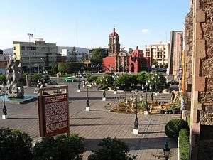
- Fountain of Dancing Water (in Spanish: Fuente de Aguas Danzarinas): The fountain, which was inaugurated on December 21, 2004, stands in the central plaza of Irapuato. Every night there is a light, music and water show. The fountain is lit up in a rainbow of colors, and the jets provide a choreographed show accompanied by music.[7]
- Irapuato Zoo (in Spanish: Parque Zoológico de Irapuato): The Irapuato Zoo, which is located on the outskirts of the city, is home to 103 mammals, 271 birds, and various species of fish.[8] The zoo was established in 1992 by engineer Emilio Tome Elias and architect Vicente Cázares Rodriguez, with the support of the then state governor, Carlos Medina Placencia.[9]
- Plaza Cibeles Mall (in Spanish: Plaza Cibeles): This is the newest and largest mall in the city of Irapuato. The mall contains many stores such as the Liverpool chain, and a Cinépolis movie theatre. The mall was named after the famous Plaza de Cibeles, a famous square in Madrid, Spain, which features a beautiful sculpture and fountain that have been adopted as a symbol for the city of Madrid.
- John Paul II Monument (in Spanish: Monumento al papa Juan Pablo II): Bronze statue of Pope John Paul II, located in the Miguel Hidalgo square next to the Irapuato Cathedral. The statue was made out of keys that were donated by all of the people of Irapuato. The bronze sculpture has a steel skeleton and has a weight of 300 kg (661 lbs). It was unveiled on February 15, 2006.[10]
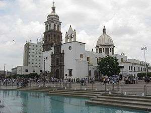
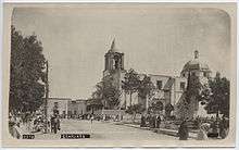
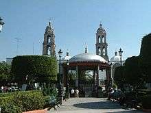
- Irapuato Cathedral (in Spanish: Catedral de Irapuato): The cathedral was built in the 16th century in the baroque style. The outside facade is also baroque. The interior is in the neoclassical architectural style. The cathedral is laid out in the traditional Latin Cross style.[11]
- Miguel Hidalgo Square (in Spanish: Plazuela Miguel Hidalgo): A large public square in the historical center of Irapuato. The square contains the Fountain of Dancing Water as well as the Irapuato Cathedral. The square is named after Miguel Hidalgo y Costilla, the father of the Mexican Independence movement.
- Little Hospital Church (in Spanish: Templo del Hospitalito): This was the first church built in lrapuato. The interior was completed in 1713 and the facade in 1733. It is baroque in style and dedicated to the Lady of Mercy (in Spanish: Señora de la Misericordia). The church is built in the traditional Latin Cross style. The main altars contain images made from corn paste. The church was originally built as a chapel for the Indians' Hospital (in Spanish: Hospital de Indios), which was built two centuries earlier by Vasco de Quiroga in 1550.[12]
- Dolphin (or Florentine) Fountain (in Spanish: Fuente de los delfines (o Florentina)): In 1864, Maximilian I of Mexico donated three bronze Florentine fountains to the state of Guanajuato. These fountains are located in lrapuato, Léon, and the city of Guanajuato.[13][14]
- Sergio Leon Chávez Stadium (in Spanish: Estadio Sergio Leon Chávez): Current home of Irapuato FC. It was one of the stadiums used in the 1986 FIFA World Cup.[15] It has a maximum capacity of 32,000 spectators.
- Sun Clock (in Spanish: Reloj del Sol): The clock is over a century old and it is located in the Juan Alvarez Square. The clock is elevated on a pedestal and column.[16]
- Canyon of the Bats (in Spanish: Cañon de los Murciélagos): It is located outside the city of Irapuato in the Sierra de Pénjamo. It is home to thousands of bats, but it is open to the public for hiking and other activities. The terrain is rugged and depending on elevation, vegetation varies from low evergreen rainforest to rainforest that loses its leaves each year. The area also contains waterfalls and natural pools.[17]
Education
The city of Irapuato is home to some private universities, and a single public university:
- The Higher Technological Institute of Irapuato (ITESI), is the only public institution decentralized from the state government.
The city is home to a research center of the Center for Advanced Research and Studies (CINVESTAV)specialized in plant biotechnology and genetics and the newly created National Center of Plant Genomics.
Some of the private universities include:
- The Irapuato campus of the Monterrey Institute of Technology and Higher Education (ITESM), (also popularly known as el Tec de Monterrey or simply as el Tec).
- The Irapuato Institute (Instituto Irapuato)
- The Irapuato campus of the Quetzalcoatl University (UQI)
- There is also a branch of the University of León (UDL) (Universidad de Léon).
- Liceo Cervantino University (Universidad Liceo Cervantino) (ULC)
Sport
The local football team is Irapuato FC.
Stadiums and Arenas
- Estadio Sergio Leon Chavez
- Plaza de Torros
- Parque Irekua
- Golf Club Santa Margarita
Notable people
- Enrique del Moral – architect.
- Silvia Navarro – actress.
- Carlos Cordero – athlete for Mexico at the 2012 London Olympics.
- Samuel Ruiz – Catholic prelate.
- Mario Castañeda – Mexican voice actor.
- Chucho Navarro – founding member of the Trio Los Panchos.
- Miguel Ángel Chico Herrera – president of PRI from 2005-2009.
- Roberto Alvarado – professional soccer player who plays for Cruz Azul in the Liga MX, and the Mexican National Team.
- Claudio González – professional soccer player who plays for Club Leon in the Liga MX.
- Óscar Razo – professional soccer player who played for Club Atlas in the Liga MX.
- Francisco Rotllán – professional soccer player who played for Mexico at the 1992 Summer Olympics in Barcelona.
- Sergio Ávila – professional soccer player who played for Chivas de Guadalajara and the Mexico U-23 national team.
- José Antonio Patlán – professional soccer player who played for Chivas de Guadalajara in 2006
- Guillermo Silviano Rivera Uribe – poet, writer, historian, public servant (State Police Director)
- Jose Sergio Sebastián Martínez Castro – poet, politician. During his administration; the "Plaza de los Fundadores" was built to its current design.
Images
 Mural depicting Miguel Hidalgo y Costilla and the Mexican Independence movement. |
 Hospitalito Church |
|
 Aguas Danzarinas Fountain |
 Irapuato's Hidalgo Garden |
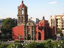
 Templo de la Soledad |

Sister cities
References
- ↑ "Historia de Irapuato". Enciclopedia de los Municipios de México. Archived from the original on 2012-03-20. Retrieved 2007-03-22.
- ↑ "2005 Census". INEGI: Instituto Nacional de Estadística, Geografía e Informática. Archived from the original on 2007-03-28. Retrieved 2007-03-22.
- ↑ "Irapuato". Questia Encyclopedia. Retrieved 2007-03-21.
- ↑ "Irapuato History". irapuato.gob.mx. Retrieved 2007-03-20.
- ↑ "Historia de la Conquista". irapuato.gob.mx. Retrieved 2007-03-20.
- ↑ NORMALES CLIMATOLÓGICAS 1971-2000 Archived 2010-11-08 at the Wayback Machine., National Meteorological Service of Mexico. Retrieved August 4, 2012 .
- ↑ "Fuentes Danzarinas". irapuato.gob.mx. Retrieved 2007-03-20.
- ↑ "Parque Zoologico de Irapuato". zooira.org.mx. Retrieved 2007-03-20.
- ↑ "Quienes Somos". zooira.org.mx. Retrieved 2007-03-20.
- ↑ "Lugares Turisticos". irapuato.gob.mx. Retrieved 2007-03-22.
- ↑ "Catedral de Irapuato". irapuato.gob.mx. Retrieved 2007-03-22.
- ↑ "Hospitalito Church". Tour By Mexico. Retrieved 2007-03-24.
- ↑ "Fuente de los Delfines". irapuato.gob.mx. Retrieved 2007-03-22.
- ↑ "Dolphin Fountain". Tour By Mexico. Retrieved 2007-03-24.
- ↑ "Estadio Sergio Leon Chávez". irapuato.gob.mx. Retrieved 2007-03-22.
- ↑ "Reloj del Sol". irapuato.gob.mx. Retrieved 2007-03-22.
- ↑ Quintanar Hinajosa, Beatriz, ed. (August 2010). "Guanajuato". Mexico Desconocido (Descubre Guanajuato Ruta de la Independencia Guia Especial) (in Spanish). Mexico City: Impresiones Aereas SA de CV: 18. ISSN 1870-9397.
External links
| Wikivoyage has a travel guide for Irapuato. |
- D IRAPUATO.COM SPANISH
- Presidencia Municipal de Irapuato Official website
- Irapuato Article on Wikipedia Español