Puerto Lumbreras
| Puerto Lumbreras | ||
|---|---|---|
| Municipality | ||
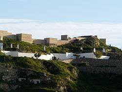 Castle of Nogalte | ||
| ||
 Puerto Lumbreras Location in Spain | ||
| Coordinates: 37°33′48″N 1°48′26″W / 37.56333°N 1.80722°WCoordinates: 37°33′48″N 1°48′26″W / 37.56333°N 1.80722°W | ||
| Country |
| |
| Autonomous Community |
| |
| Province | Region of Murcia | |
| Comarca | Alto Guadalentín | |
| Government | ||
| • Mayor | María Ángeles Túnez García (PP) | |
| Area | ||
| • Total | 338 km2 (131 sq mi) | |
| Elevation(AMSL) | 465 m (1,526 ft) | |
| Population (2012) | ||
| • Total | 14,742 | |
| • Density | 44/km2 (110/sq mi) | |
| Time zone | UTC+1 (CET) | |
| • Summer (DST) | UTC+2 (CEST (GMT +2)) | |
| Postal code | 30890 | |
| Area code(s) | +34 (Spain) + 968 (Murcia) | |
| Website |
www | |

Puerto Lumbreras (Spanish: [ˈpweɾto lumˈbɾeɾas]) is a Spanish municipality in the autonomous community of Murcia. It has a population of 12,881 (2006) and an area of 139 km² .
Gallery
 Location of Puerto Lumbreras.
 Puerto Lumbreras City Office in Doctor Salvador Caballeo Garcia area
 Picture show by flood damage in Puerto Lumreras on October, 1973
External links
- Ayuntamiento de Puerto Lumbreras (in Spanish)
- Business guide and General Information in English and Spanish (in English)
This article is issued from
Wikipedia.
The text is licensed under Creative Commons - Attribution - Sharealike.
Additional terms may apply for the media files.