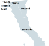
Municipalities of Baja California
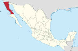
Baja California is a state in Northwest Mexico that is divided into five municipalities.[1]. According to the 2015 Mexican Intercensal Survey, Baja California is the 13th most populous state with 3,315,766 inhabitants and the 12th largest by land area spanning 73,290.08 square kilometres (28,297.46 sq mi).[1][2]
Municipalities in Baja California are administratively autonomous of the state according to the 115th article of the 1917 Constitution of Mexico.[3] Their legal framework derives from Title VI of the state Constitution[4] and the state's 2001 Law of the Municipal Regime.[5] Every three years, citizens elect a municipal president (Spanish: presidente municipal) by a plurality voting system who heads a concurrently elected municipal council (ayuntamiento) responsible for providing public services for their constituents.[4] The municipal council consists of a variable number of trustees and councillors (regidores y síndicos).[6] Municipalities are responsible for public services (such as water and sewerage), street lighting, public safety, traffic, supervision of slaughterhouses and the maintenance of public parks, gardens and cemeteries.[7] They may also assist the state and federal governments in education, emergency fire and medical services, environmental protection and maintenance of monuments and historical landmarks. Since 1984, they have had the power to collect property taxes and user fees, although more funds are obtained from the state and federal governments than from their own income.[7] Municipalities may establish internal subdivisions called delegaciones and subdelegaciones[8] in accordance with Article 29 of the Law of the Municipal Regime.[5]
The largest municipality by population in Baja California and second largest in Mexico is Tijuana with 1,641,570 residents, representing around half (49.5%) of the population of the state. The smallest municipality by population is Playas de Rosarito with 96,734 residents.[1] Ensenada, which spans 53,199.79 km2 (20,540.55 sq mi), is the largest municipality by area in the state and in the country. Playas de Rosarito is the smallest municipality by area spanning 500.67 km2 (193.31 sq mi).[2] The first municipality to incorporate was Ensenada on May 15, 1882 and the newest municipality is Rosarito which incorporated July 21, 1995.[9]
Municipalities
- Municipalities in Baja California
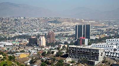 Downtown Tijuana, Baja California's largest municipality by population
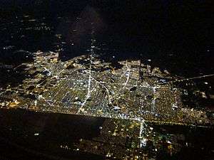 Mexicali, state capital and second largest municipality by population in Baja California
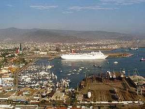 The port of Ensenada, Baja California's third largest municipality by population
 Areal view of Tecate, the fourth largest municipality by population in Baja California
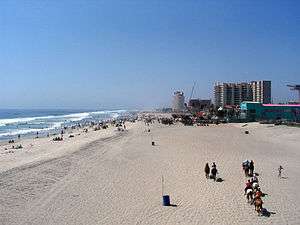 Beach in Playas de Rosarito, Baja California's smallest municipality by population
| Name | Municipal seat | Population (2015)[1][10] |
Population (2010)[11] |
Change | Land area[2] | Population density (2015) |
Incorporation date[9] | |
|---|---|---|---|---|---|---|---|---|
| km2 | sq mi | |||||||
| Ensenada | Ensenada | 486,639 | 466,814 | +4.2% | 53,199.79 | 20,540.55 | 9.1/km2 (23.7/sq mi) | May 15, 1882 |
| Mexicali |
Mexicali | 988,417 | 936,826 | +5.5% | 15,665.22 | 6,048.38 | 63.1/km2 (163.4/sq mi) | November 20, 1914 |
| Playas de Rosarito | Rosarito | 96,734 | 90,668 | +6.7% | 500.67 | 193.31 | 193.2/km2 (500.4/sq mi) | July 21, 1995 |
| Tecate | Tecate | 102,406 | 101,079 | +1.3% | 2,688.89 | 1,038.19 | 38.1/km2 (98.6/sq mi) | March 11, 1917 |
| Tijuana | Tijuana | 1,641,570 | 1,559,683 | +5.3% | 1,235.51 | 477.03 | 1,328.7/km2 (3,441.2/sq mi) | March 11, 1917 |
| Baja California | — | 3,315,766 | 3,155,070 | +5.1% | 73,290.08 | 28,297.46 | 45.2/km2 (117.2/sq mi) | — |
| Mexico[12] | — | 119,938,473 | 112,336,538 | +6.8% | 1,972,550 | 761,605.81 | 60.8/km2 (157.5/sq mi) | — |
References
- 1 2 3 4 "Número de habitantes". INEGI (National Institute of Statistics and Geography). Retrieved July 15, 2017.
- 1 2 3 "Unidad de Microrregiones Cedulas de Informacion Municipal (SCIM)" (in Spanish). Secretara de Desarrollo Social. Retrieved November 18, 2017.
- ↑ "Constitución Política de los Estados Unidos Mexicanos". Article 115, of 1917 (in Spanish). Retrieved September 27, 2017.
- 1 2 "Constitución Política del Estado Libre y Sobrerano de Baja California". Title VI, Act of January 19, 2018 (PDF) (in Spanish). Retrieved February 25, 2018.
- 1 2 "Ley del Régimen Municipal para el Estado de Baja California" (PDF) (in Spanish). Baja California State Congress. November 10, 2017. Retrieved February 25, 2018.
- ↑ OECD (November 12, 2004). New Forms of Governance for Economic Development. OECD Publishing. p. 121. ISBN 9264015329.
- 1 2 International Business Publications (2009). Mexico Company Laws and Regulations Handbook. p. 42. ISBN 1-4330-7030-8.
- ↑ Polo Martínez, Humberto (November 2012). Administración pública comunitaria y gobierno local en México: Las autoridades auxiliares municipales (PDF) (in Spanish). National Institute of Public Administration. p. 114. ISBN 978-607-9026-26-4.
- 1 2 Estado de Baja California. División Territorial de 1810 a 1995 (PDF) (in Spanish). Mexico: INEGI. 1996. pp. 65–66. ISBN 970-13-1487-5.
- ↑ "Tabulados de la Encuesta Intercensal 2015" (xls) (in Spanish). INEGI. Retrieved July 15, 2017.
- ↑ "Localidades y su población por municipio según tamaño de localidad" (PDF) (in Spanish). INEGI. Retrieved July 15, 2017.
- ↑ "Población" (in Spanish). INEGI. Retrieved January 20, 2018.