Ensenada Municipality
| Ensenada Municipality Municipio de Ensenada | ||
|---|---|---|
| Municipality | ||
| Municipality of Ensenada | ||
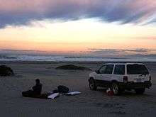
 The Pacific coast of Ensenada Municipality | ||
| ||
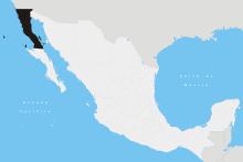
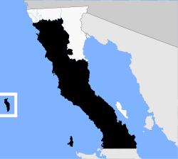 Location of Ensenada in Baja California | ||
| Coordinates: 30°00′N 115°30′W / 30°N 115.5°WCoordinates: 30°00′N 115°30′W / 30°N 115.5°W | ||
| Country |
| |
| State |
| |
| Municipal seat | Ensenada | |
| Largest city | Ensenada | |
| Municipality established | December 29, 1953[1] | |
| Government | ||
| • Municipal president | Gilberto Antonio Hirata Chico (PRI) | |
| Area | ||
| • Total | 52,482.4 km2 (20,263.6 sq mi) | |
| Population (2010) | ||
| • Total | 466,814 | |
| • Density | 8.9/km2 (23/sq mi) | |
| Data source: INEGI 2010 Census | ||
| Time zone | UTC−8 (Northwest (US Pacific)) | |
| • Summer (DST) | UTC−7 (Northwest) | |
| INEGI code | 001 | |
| Website | (in Spanish) Ayuntamiento de Ensenada | |
| Source: Enciclopedia de los Municipios de México | ||

The municipality (Spanish: municipio) of Ensenada, with a land area of 52,482.40 km2 (20,263.57 sq mi), takes up the majority of the state of Baja California. It is the largest municipality in Mexico and in the Americas by area. It contains all of Baja California apart from a strip at the north and, at the northeast extremity of the state, the municipality of Mexicali. It is bordered by the Pacific Ocean on the west, the Gulf of California on the east, and by all of the other municipalities in Baja California on the North. Its municipal seat (Spanish: cabecera municipal) is Ensenada (31°51′28″N 116°36′21″W / 31.85778°N 116.60583°W), which lies near the northwest corner of the municipality, although almost all of the municipality's territory lies far to its southeast. Its current (as of 2009) municipal president (Spanish: presidente municipal) is Enrique Pelayo Torres. A major port is planned to be built in Punta Colonet, a largely uninhabited area 80 km (50 mi) south of the city of Ensenada. Located offshore, Guadalupe Island is part of the municipality, making Ensenada the westernmost municipality of Latin America.
In 2010 the municipality had a population of 466,814 inhabitants. The 2005 census recorded 413,481 inhabitants.
Subdivisions
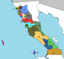
Territorially massive Ensenada municipality is administratively subdivided into 23 boroughs (Spanish: delegaciones), of which Ensenada form the city of Ensenada, the municipal seat:
- La Mision - Borough seat: La Misión
- El Porvenir
- Francisco Zarco (Guadalupe)
- Real del Castillo
- El Sauzal
- Ensenada
- San Antonio de las Minas
- Maneadero
- Santo Tomás
- Erendira - Borough seat: Eréndira
- San Vicente
- Valle de la Trinidad
- Punta Colonet - Borough seat: Punta Colonet
- Camalu - Borough seat: Camalú
- Vicente Guerrero
- San Quintin - Borough seat: San Quintín
- El Rosario - Borough seat: El Rosario
- Puertecitos - Borough seat: Puertecitos
- El Marmol
- Punta Prieta - Borough seat: Punta Prieta
- Bahía de los Ángeles
- Calmallí (Villa Jesús María)
- Isla de Cedros
Demographics
As of 2010, the municipality had a total population of 466,814.[2]
As of 2010, the city of Ensenada had a population of 279,765.[2] Other than the city of Ensenada, the municipality had 3,245 localities, the largest of which (with 2010 populations in parentheses) were:
Classified as urban:[2]
- Rodolfo Sánchez Taboada (Maneadero) (22,957)
- Lázaro Cárdenas (16,294)
- Vicente Guerrero (11,455)
- El Sauzal de Rodríguez (8,832)
- Camalú (8,621)
- Benito García (El Zorrillo) (6,598)
- Emiliano Zapata (5,756)
- San Quintín (4,777)
- San Vicente (4,362)
- Colonia Lomas de San Ramón (Triquis) (3,805)
- Real del Castillo Nuevo (Ojos Negros) (3,533)
- Ejido Papalote (3,413)
- Lázaro Cárdenas (Valle de la Trinidad) (3,366)
- Ejido México (Punta Colonet) (3,278)
- Colonia Nueva Era (3,256)
- Rancho Verde (2,758)
- Francisco Zarco (Valle de Guadalupe) (2,664)
- Santa Fe (2,632)
Classified as rural:[2]
- Luis Rodríguez (El Vergel) (2,281)
- Colonia Benito Juárez (1,933)
- Ejido Profesor Graciano Sánchez (1,856)
- El Rosario de Arriba (1,704)
- Salvador Rosas Magallón (1,520)
- Ejido Eréndira (1,461)
- Poblado Chulavista (El Chorizo) (1,442)
- El Porvenir (Valle de Guadalupe) (1,416)
- Licenciado Gustavo Díaz Ordaz (1,394)
- Colonia Gómez Morín (1,362)
- Isla de Cedros (1,339)
- Poblado Héroes de Chapultepec (1,260)
- Santa María (Los Pinos) (1,255)
- La Providencia (1,253)
- Ejido General Leandro Valle (1,174)
- Ejido Francisco Villa (San Simón) (1,151)
- Las Brisas (1,078)
- Fraccionamiento del Valle (1,052)
- Pueblo Benito García (1,028)
See also
- Additional Information
- Punta Colonet, Baja California
- Maneadero
Notes
- ↑ (in Spanish) pp. 78–79, La Transformación de Baja California en Estado, 1931–1952 Archived 2011-09-29 at the Wayback Machine., Lawrence Douglas Taylor Hansen, Estudios Fronterizos, 1, #1 (January–June 2000), UABC, Mexicali, pp. 47–87.
- 1 2 3 4 "Ensenada". Catálogo de Localidades. Secretaría de Desarrollo Social (SEDESOL). Retrieved 23 April 2014.
References
- Ensenada: Its background, founding, and early development http://www.sandiegohistory.org/journal/84winter/ensenada.htm
- (in Spanish) Link to tables of population data from Census of 2005 INEGI: Instituto Nacional de Estadística, Geografía e Informática
- (in Spanish) Los Municipios con Mayor y Menor Extensión Territorial Instituto Nacional para el Federalismo y el Desarrollo Municipal
- (in Spanish) Subdivisions (delegaciones)
External links
| Wikimedia Commons has media related to Ensenada Municipality. |
- (in Spanish) Ayuntamiento de Ensenada Official government website.
- (in English) Property frenzy in Baja California, Diane Lindquist, San Diego Union-Tribune, April 24, 2006. Article on planned port construction at Punta Colonet.