Mullumbimby
| Mullumbimby New South Wales | |
|---|---|
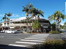
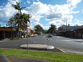 Burringbar Street—Mullumbimby's main street | |
|
Mullumbimby | |
| Coordinates | 28°33′S 153°30′E / 28.550°S 153.500°ECoordinates: 28°33′S 153°30′E / 28.550°S 153.500°E |
| Population | 3,596 (2016 census)[1] |
| Postcode(s) | 2482 |
| Location |
|
| LGA(s) | Byron Shire |
| State electorate(s) | Ballina[2] |
| Federal Division(s) | Richmond[3] |
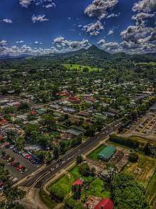
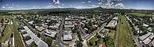
Mullumbimby is an Australian town in Byron Shire in the Northern Rivers region of New South Wales. It promotes itself as "The Biggest Little Town in Australia".[4] The town lies at the foot of Mount Chincogan in the Brunswick Valley about 9 kilometres (5.5 miles) by road from the coast. At the 2016 census, Mullumbimby and the surrounding area had a population of 3,596 people.[1] Locals refer to the town as "Mullum".
Origins and name
Originally occupied by the Bundjalung people, by the 1850s Europeans had established a camp site at the junction of two arms of the Brunswick River. This grew to become a village and later the township of Mullumbimby. Mullumbimby was originally a centre for the timber industry. Notably, red cedar was collected in great quantities from around the area, a part of the far northern New South Wales' "Big Scrub".[6]
The town was a logical site for settlement by the timber hunters, as the Brunswick River is tidal in the town and navigable to that point, allowing logs to be floated down the river to its mouth at Brunswick Heads. The town's central location gave access to most of the catchment area, and it provided the best position for bullock teams to cross the river with their wagons loaded with timber. At low tide it is still possible to see the shallow region where the bullocks made the crossing of the Brunswick River, under the current "Federation Bridge" on Murwillumbah Road.
The name "Mullumbimby", meaning "small round hill", was given to the district by Aboriginal people. The name is derived from the Bandjalung-Yugambeh dialect mulubinba (possibly also pertaining to a native fern which grew in the vicinity).[7] Although some sources claim this is because of the proximity of Mount Chincogan, Chincogan is probably too prominent in the landscape to fit the name.[8] An alternative theory is that it refers to another smaller and rounder hill. Suggestions include a medium hill to the north of Left Bank road, on which the towns water tower is located, or a smaller hill on Coolamon Scenic Drive, situated on the Daly Family Farm, near the current golf course. This latter hill is possibly supported by the abundant grass flats which surrounded it, known as Mullumbimby Grass. These naturally open grass flats, presumably hunting grounds for the local Bundjalung tribes, were later used by early European timber hunters to graze their bullock teams.[6] The significance of this area lay not only in the feed it provided, but that some grasses in the naturally cleared area aided bullocks which had swallowed salt water when dragging timber into the surf for collection by nearby ships.
Geography
Mullumbimby is about 4 kilometres (2 mi) west of the Pacific Highway, near where the now closed Murwillumbah railway line crosses the Brunswick River. The line opened in 1894 and was closed in 2004 because of an argument over funding between federal and state politicians, despite community resistance across the region. Closure of the railway line between Murwillumbah and Casino has reduced transport options in the region.
The Brunswick River starts in Mullumbimby, at the meeting of Main Arm and Mullumbimby creeks.
Mullumbimby is close to the localities of Ocean Shores, Brunswick Heads and Wilsons Creek. Its hinterland area includes the locales of Goonengerry, Huonbrook, Koonyum Range, Main Arm, Montecollum, Palmwoods, Wanganui and Wilsons Creek and coincides with the postcode area of 2482[9] which has a diamond shape of around 35 km by 45 km.
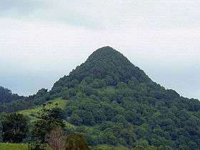
The main geographical feature of Mullumbimby, Mount Chincogan, was a minor lava plug of the now extinct Tweed shield volcano. The nearby Mount Warning was the main plug.
Culture and history
Mullumbimby was a separate municipality from 1908 until 1980 when it was forced to amalgamate with the Byron Shire. The Byron Shire Council offices were relocated to Mullumbimby in the 1990s.
Byron Shire, including Mullumbimby and nearby Byron Bay, became a centre of alternative or counter culture alongside the extant mainstream culture in the 1970s and 1980s, and remains so today. The mixed male choir Dustyesky performs Russian-language folk songs and received major coverage on the Russian television broadcaster Channel One.[10][11]
Once the most notable specimens of the valuable timber trees had been collected (most notably red cedar, but also Australian Teak, Hoop Pine, Rosewood, Silky Oak and Black and Red Bean), the Big Scrub timber trade collapsed and Mullumbimby became primarily a farming community. Like many areas of the Big Scrub, allotments were given in Mullumbimby and the surrounding areas by the New South Wales government on the condition that the owner cleared the land for agricultural use.[12] Beef and dairy, along with bananas and sugar cane have traditionally been the notable products of the area. However, the subdivision of many of the larger farms and the emergence of numerous small scale farmers has led to a higher diversity of products. A weekly farmers' market has been developed to exhibit local produce.[13]
A static inverter plant of HVDC Directlink is located at Laverty's Gap near Mullumbimby. This inverter plant was previously the site of a 288 kW hydroelectric power scheme that powered Mullumbimby, Byron Bay and Bangalow from 1926, using water from a weir in nearby Wilsons Creek.[14][15] The scheme was the fourth hydro electric power station in NSW and only the fifth on mainland Australia.[16] Powering Mullumbimby for the first time in 1925, the scheme made Mullumbimby one of the first country towns in NSW to receive electricity.[16] Although decommissioned in 1990, it is now of state heritage significance.[16] The hydroelectric scheme was designed by William Corin (1867–1929).[17] The site is being considered for pumped-storage hydroelectricity.[18][19]
Heritage listings
Mullumbimby has a number of heritage-listed sites, including:
- Wilsons Creek Road: Mullumbimby Hydro-electric Power Station Complex[20]
Stone arrangement
A stone arrangement which is located 40 kilometers from Mullumbimby Is said to date back to the Paleolithic Age, and predates Stonehenge.[21] It was discovered in the late 1930s by Frederic Slater and made headlines across Australia. Some researchers believe the inscriptions on the stones contain the earliest form of human language. The site has been damaged throughout the years, and the exact location has yet to be revealed to the public with fears that it may lead to more vandalism.[22]
Health
Mullumbimby hosts an anti-vaccination group. As of 2013, the town's vaccination rate was the lowest in Australia, with only 46% to 49% of one, two and five year-old children in the 2482 postcode fully immunised, in contrast with a state average in the low 90s. Richmond Valley, a region close to Mullumbimby, had the lowest overall vaccination rate, in part due to a high number of "conscientious objectors" to the practice. Health officials have cited education and timely reminders as key factors in improving the vaccination rate.[23][24]
Byron Shire, in which Mullumbimby is situated, is also the only remaining local government area in the Northern Rivers region to reject fluoridation of its water supply.[25]
Sport and recreation
The Mullumbimby Giants is the local rugby league club that competes in the Northern Rivers Regional Rugby League competition.
Notable people
- Iggy Azalea, Grammy-nominated multi-platinum selling rapper, songwriter and model (born 1990)
- Bob Bellear, first Aboriginal barrister and judge in Australia (1944–2005)
- Jy Hitchcox, Rugby League player (born 1989)
- Trent Knobel, AFL player with Brisbane Bears and St Kilda Football Club
- Cody Nelson, Rugby League player (born 1988)
- Petria Thomas, swimming Olympic gold medalist (born 1975)
- Edwin Wilson, author of Mullumbimby Dreaming and The Mullumbimby Kid (born 1942)
- Joel Turner, beatboxer, singer, songwriter, instrumentalist and record producer (born 1987)
See also
References
- 1 2 Australian Bureau of Statistics (27 June 2017). "Mullumbimby (State Suburb)". 2016 Census QuickStats. Retrieved 25 November 2017.
- ↑ "NSW Electoral District – Ballina". Electoral Commission NSW. Retrieved 10 April 2015.
- ↑ "Federal Division – Richmond". Australian Electoral Commission. 2007.
- ↑ "Mullumbimby". Byron Bay Beaches. Retrieved 20 May 2011.
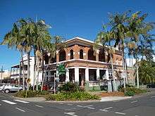
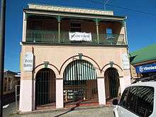
- ↑ "Westpac Bank (Former) – NSW Environment & Heritage". www.environment.nsw.gov.au.
- 1 2 "more history".
- ↑ "Mullumbimby". Geographical Names Register (GNR) of NSW. Geographical Names Board of New South Wales. Retrieved 26 October 2011.
- ↑ "Byron Bay Hinterland". Australian Traveller. Archived from the original on 18 February 2011. Retrieved 11 May 2011.
- ↑ "Australia Post postcode 2482". Australia Post.
- ↑ "Vodka-swilling choir from Mullumbimby cracks the big time in Russia" by Joanne Shoebridge and Samantha Turnbull, ABC News, 30 May 2017
- ↑ "Australian Choir Nails Classic Russian Songs, Yet None Speak Russian!", Sputnik, 27 May 2017
- ↑ "Big Scrub: A cleared landscape in transition back to forest?".
- ↑ "Mullumbimby Farmers Markets".
- ↑ "Mullumbimby". The Sydney Morning Herald. 2004-02-08.
- ↑ Touring The Hydro – Mullumbimby's Heritage Power Station (1 of 6) on YouTube
- 1 2 3 "Mullumbimby Hydro-electric Power Station Complex".
- ↑ "Biography – William Corin". Australian Dictionary of Biography.
- ↑ "Pumped about hydro in Mullum". Byron Shire News. 27 September 2017. Retrieved 28 September 2017.
- ↑ "Pumped-storage hydro potential for Mullumbimby". Echonetdaily. 28 September 2017. Retrieved 28 September 2017.
- ↑ "Mullumbimby Hydro-electric Power Station Complex, New South Wales State Heritage Register (NSW SHR) Number H01926". New South Wales State Heritage Register. Office of Environment and Heritage. Retrieved 18 May 2018.
- ↑ http://www.couriermail.com.au/news/queensland/is-australias-stonehenge-near-mullumbimby-where-civilisation-began-or-historical-hoax/news-story/8a0fe799bf3e97d69deb9eb744a36169
- ↑ "The photo that could rewrite history".
- ↑ "Mullumbimby vaccination rate below 50 per cent". abc.net.au. ABC. 2013-05-20. Retrieved 2015-04-29.
- ↑ "Low vaccination rates make Northern Rivers most "dangerous" place to raise children: State Opposition". abc.net.au/local. ABC. 2014-03-28. Retrieved 2015-04-29.
- ↑ Broome, Hamish (2014-12-31). "Turbulent times in our patch". Northern Star. APN. Retrieved 2015-04-29.
External links

- "Brunswick River catchment" (map). Office of Environment and Heritage. Government of New South Wales.