Mukhmas
| Mukhmas | |
|---|---|
| Other transcription(s) | |
| • Arabic | مُخماس |
 Mikhmas from the west | |
 Mukhmas Location of Mukhmas within Palestine | |
| Coordinates: 31°52′22″N 35°16′37″E / 31.87278°N 35.27694°ECoordinates: 31°52′22″N 35°16′37″E / 31.87278°N 35.27694°E | |
| Palestine grid | 176/142 |
| Governorate | Jerusalem |
| Government | |
| • Type | Village council |
| Population (2006) | |
| • Jurisdiction | 1,878 |
| Name meaning | Michmash [1] |
Mikhmas (Arabic: مُخماس) is a Palestinian village in the Jerusalem Governorate, located Northeast of Jerusalem in the central West Bank. According to the Palestinian Central Bureau of Statistics, the town had a population of 1,878 in 2006.[2]
Location
Mikhmas is located 11.2 kilometers (7.0 mi) (horizontally) north-east of Jerusalem. It is bordered by Deir Dibwan to the east and north, Burqa to the west, and Jaba' to the south.[3]
History
Ceramics from the Byzantine era have been found here.[4] Clermont-Ganneau also found Byzantine remains here, speculating that they might be from the convent found by abbot Firminus, a disciple of St. Sabas.[5]
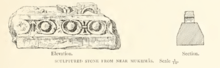
The SWP noted about Mikhmas: "In the village are remains of old masonry, apparendy a church. A pillar-shaft is built into a wall in the north-west corner of the village. Two lintel stones are built over the door of another house, one with three crosses in circles, the second with a design apparently cut in half."[6]
Ottoman era
Mukhmas was incorporated into the Ottoman Empire in 1517 with all of Palestine, and in 1596 it appeared in the tax registers as being in the nahiya of Al-Quds in the liwa of Al-Quds under the name of Mihmas. It had a population of 24 household;[7] who were all Muslims. They paid a fixed Ziamet tax-rate of 33,3 % on agricultural products, including wheat, barley, olive trees, fruit trees, goats and beehives, in addition to occasional revenues; a total of 2,200 akçe.[7]
In 1838, it was noted as a Muslim village, Mukhmas, located in the area immediately north of Jerusalem.[8][9]
In 1863, Victor Guérin observed a great number of sizeable antique stones in the modern houses. About thirty cisterns and silos dug in the rock also dated back to antiquity.[10] An Ottoman village list of about 1870 showed that Muchmas had 36 houses and a population of 120, though the population count included men, only.[11][12]
In 1883 the Palestine Exploration Fund's Survey of Western Palestine (SWP) described Mukhmas as: "A small stone village on the slope of a ridge. The houses are poor and scattered. The water supply is from cisterns. It has a well to the east, and some scattered figs to the west. On the north are rock-cut tombs; an ancient road leads past the place. There are foundations and remains of former buildings in the village; on the south a steep slope leads clown to the great valley, Wady Suweinit. This place is the ancient Michmash, which is placed by the Onomasticon 9 Roman miles from Jerusalem. The distance is 7 1/2 English or 8 Roman miles in a line."[13]
In 1896 the population of Muchmas was estimated to be about 288 persons.[14]
British Mandate era
In the 1922 census of Palestine conducted by the British Mandate authorities, Mukhmas had a population of 361,[15] increasing in the 1931 census to 404 inhabitants, in 80 houses.[16]
In the 1945 statistics, Mukhmas had a population of 540 Muslims,[17] and a land area of 13,479 dunams.[18] Of this, 569 dunams were designated for plantations and irrigable land, 2,274 for cereals,[19] while 28 dunams were built-up, urban land.[20]
Jordanian era
In the wake of the 1948 Arab–Israeli War, and after the 1949 Armistice Agreements, Mukhmas came under Jordanian rule.
The Jordanian census of 1961 found 774 inhabitants.[21]
Post 1967
After the Six-Day War in 1967, Mukhmas has been under Israeli occupation. After the 1995 accords, about 6.4% of the village land was defined as Area B land, while the remaining 93.6% was defined as Area C.[22]
The Israelis have confiscated land in Mukhmas for its military bases, roads, and Israeli settlements, including Sha'ar Binyamin and Ma'ale Mikhmas.[22] In 2010, Israeli Settlers from Ofra and Migron uprooted several hundred olive trees owned by the people of Mukhmas.[22]
In 2011, Israeli settlers from Ma'ale Mikhmas set fire to about a hundred olive trees, belonging to the people of Mukhmas.[22]
References
- ↑ Palmer, 1881, p. 323
- ↑ Projected Mid -Year Population for Jerusalem Governorate by Locality 2004- 2006 Archived 2012-02-07 at the Wayback Machine. Palestinian Central Bureau of Statistics.
- ↑ Mikhmas village profile, ARIJ, p. 4
- ↑ Dauphin, 1998, pp. 841–2
- ↑ Clermont-Ganneau, 1896, pp. 282-283
- ↑ Conder and Kitchener, 1883, SWP III, p. 149
- 1 2 Hütteroth and Abdulfattah, 1977, p. 116
- ↑ Robinson and Smith, 1841, vol. 3, 2nd appendix, p. 122
- ↑ Robinson and Smith, 1841, vol. 2, pp. 115, 117
- ↑ Guérin, 1869, p. 63
- ↑ Socin, 1879, p. 158 It was also noted to be in the Bire district
- ↑ Hartmann, 1883, p. 127, noted 35 houses
- ↑ Conder and Kitchener, 1883, SWP III, p. 12
- ↑ Schick, 1996, p. 121, also writes that this locality is on Socin, p. 153. That is clearly a typo, this place is on Socin, p. 158 (The number of male inhabitants given in Socin, 120, is correct)
- ↑ Barron, 1923, Table VII, Sub-district of Jerusalem, p. 14
- ↑ Mills, 1932, p. 41
- ↑ Government of Palestine, Department of Statistics, 1945, p. 25
- ↑ Government of Palestine, Department of Statistics. Village Statistics, April, 1945. Quoted in Hadawi, 1970, p. 57
- ↑ Government of Palestine, Department of Statistics. Village Statistics, April, 1945. Quoted in Hadawi, 1970, p. 103
- ↑ Government of Palestine, Department of Statistics. Village Statistics, April, 1945. Quoted in Hadawi, 1970, p. 153
- ↑ Government of Jordan, Department of Statistics, 1964, p. 24
- 1 2 3 4 Mikhmas village profile, ARIJ, pp. 16-17
Bibliography
- Barron, J. B., ed. (1923). Palestine: Report and General Abstracts of the Census of 1922. Government of Palestine.
- Clermont-Ganneau, C.S. (1896). [ARP] Archaeological Researches in Palestine 1873-1874, translated from the French by J. McFarlane. 2. London: Palestine Exploration Fund.
- Conder, C.R.; Kitchener, H.H. (1883). The Survey of Western Palestine: Memoirs of the Topography, Orography, Hydrography, and Archaeology. 3. London: Committee of the Palestine Exploration Fund.
- Dauphin, Claudine (1998). La Palestine byzantine, Peuplement et Populations. BAR International Series 726 (in French). III : Catalogue. Oxford: Archeopress. ISBN 0-860549-05-4.
- Government of Jordan, Department of Statistics (1964). First Census of Population and Housing. Volume I: Final Tables; General Characteristics of the Population (PDF).
- Government of Palestine, Department of Statistics (1945). Village Statistics, April, 1945.
- Guérin, V. (1869). Description Géographique Historique et Archéologique de la Palestine (in French). 1: Judee, pt. 3. Paris: L'Imprimerie Nationale.
- Hadawi, S. (1970). Village Statistics of 1945: A Classification of Land and Area ownership in Palestine. Palestine Liberation Organization Research Center.
- Hartmann, M. (1883). "Die Ortschaftenliste des Liwa Jerusalem in dem türkischen Staatskalender für Syrien auf das Jahr 1288 der Flucht (1871)". Zeitschrift des Deutschen Palästina-Vereins. 6: 102–149.
- Hütteroth, Wolf-Dieter; Abdulfattah, Kamal (1977). Historical Geography of Palestine, Transjordan and Southern Syria in the Late 16th Century. Erlanger Geographische Arbeiten, Sonderband 5. Erlangen, Germany: Vorstand der Fränkischen Geographischen Gesellschaft. ISBN 3-920405-41-2.
- Mills, E., ed. (1932). Census of Palestine 1931. Population of Villages, Towns and Administrative Areas. Jerusalem: Government of Palestine.
- Palmer, E.H. (1881). The Survey of Western Palestine: Arabic and English Name Lists Collected During the Survey by Lieutenants Conder and Kitchener, R. E. Transliterated and Explained by E.H. Palmer. Committee of the Palestine Exploration Fund.
- Robinson, E.; Smith, E. (1841). Biblical Researches in Palestine, Mount Sinai and Arabia Petraea: A Journal of Travels in the year 1838. 2. Boston: Crocker & Brewster.
- Robinson, E.; Smith, E. (1841). Biblical Researches in Palestine, Mount Sinai and Arabia Petraea: A Journal of Travels in the year 1838. 3. Boston: Crocker & Brewster.
- Schick, C. (1896). "Zur Einwohnerzahl des Bezirks Jerusalem". Zeitschrift des Deutschen Palästina-Vereins. 19: 120–127.
- Socin, A. (1879). "Alphabetisches Verzeichniss von Ortschaften des Paschalik Jerusalem". Zeitschrift des Deutschen Palästina-Vereins. 2: 135–163.
External links
- Welcome to Mikhmas
- Survey of Western Palestine, Map 17: IAA, Wikimedia commons
- Mukhmas village (fact sheet), Applied Research Institute–Jerusalem (ARIJ)
- Mikhmas village profile, ARIJ
- Mikhmas aerial photo, ARIJ
- Locality Development Priorities and Needs in Mukhmas, ARIJ
