Mount Bethel, Pennsylvania
| Mount Bethel, Pennsylvania | |
|---|---|
| Unincorporated community | |
 Mount Bethel  Mount Bethel | |
| Coordinates: 40°54′17″N 75°6′42″W / 40.90472°N 75.11167°WCoordinates: 40°54′17″N 75°6′42″W / 40.90472°N 75.11167°W | |
| Country | United States |
| State | Pennsylvania |
| County | Northampton |
| Township | Upper Mount Bethel |
| Elevation | 525 ft (160 m) |
| Time zone | UTC-5 (Eastern (EST)) |
| • Summer (DST) | UTC-4 (EDT) |
| ZIP code | 18343 |
| Area code(s) | 570 and 272 |
| GNIS feature ID | 1213141[1] |
Mount Bethel is an unincorporated community in Upper Mount Bethel Township in Northampton County, Pennsylvania, United States. Mount Bethel is located along Pennsylvania Route 611 north of the intersection with Pennsylvania Route 512.[2]
References
- ↑ "Mount Bethel". Geographic Names Information System. United States Geological Survey.
- ↑ Northampton County, Pennsylvania Highway Map (PDF) (Map). PennDOT. 2013. Retrieved January 28, 2014.
Municipalities and communities of Northampton County, Pennsylvania, United States | ||
|---|---|---|
| Cities | 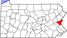 | |
| Boroughs | ||
| Townships | ||
| CDPs | ||
| Unincorporated communities | ||
| Footnotes | ‡This populated place also has portions in an adjacent county or counties | |
This article is issued from
Wikipedia.
The text is licensed under Creative Commons - Attribution - Sharealike.
Additional terms may apply for the media files.