Morland, Cumbria
| Morland | |
|---|---|
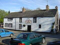 The Crown Inn | |
 Morland Morland shown within Cumbria | |
| Population | 374 (2011) |
| OS grid reference | NY5922 |
| Civil parish |
|
| District | |
| Shire county | |
| Region | |
| Country | England |
| Sovereign state | United Kingdom |
| Post town | PENRITH |
| Postcode district | CA10 |
| Dialling code | 01931 |
| Police | Cumbria |
| Fire | Cumbria |
| Ambulance | North West |
| EU Parliament | North West England |
| UK Parliament | |
Morland is a village and civil parish in the rolling hills of the Eden Valley in the Eden District of Cumbria, England. It includes the hamlets of Town Head and Morland Moor, and at the 2011 UK Census it had a population of 374.[1]
Location
Morland is centrally located in the Eden Valley, a scenic, rural area lying a few miles from the Lake District to the West, the Pennines to the East and the Yorkshire Dales to the South. The area is characterised by rolling hills and farmland.
History
Morland is believed to have been settled for at least 1500 years, perhaps because of the Powdonnet Spring that rises by the side of the road leaving the village towards Cliburn. A Viking sword was found buried in the churchyard in the 19th century, which might suggest some Viking influence in the area. In the early Middle Ages the area was contested by Scotland and England, and so Morland was not included in the Domesday Book in 1086.
Village Features
Morland's church, Church of St Lawrence (alt. Laurence), is unique in Cumbria, as it has a Saxon tower.
The village has a pub - the Crown Inn - and the Mill Yard Café[2], as well as a community shop. It has a primary school, the Morland Area Church of England Primary School, with approximately 60-70 pupils. The villages of Morland and Newby have a shared village hall, in which many activities take place.
The Eden Valley is a popular destination for holidaymakers, and Morland has a significant amount of accommodation for visitors.[3][4][5]
Governance
The ecclesiastical parish includes the townships (villages) of King's Meaburn, Newby and Sleagill.
An electoral ward in the same name exists. This ward stretches north to Cliburn with a total population of 1,300.[6]
Location grid
Places adjacent to Morland, Cumbria | ||||||||||
|---|---|---|---|---|---|---|---|---|---|---|
| ||||||||||
See also
References
- ↑ "Parish population 2011". Retrieved 22 June 2015.
- ↑ "Mill Yard Café". Retrieved 10 August 2018.
- ↑ "Morland House". Retrieved 10 August 2018.
- ↑ "Morland Hall". Retrieved 10 August 2018.
- ↑ "Greengill Holidays". Retrieved 10 August 2018.
- ↑ "Ward population 2011". Retrieved 22 June 2015.
External links
- Visit Cumbria: Morland
- Church of St Lawrence, Morland
- Morland Area C.of E. Primary School
- Cumbria County History Trust: Morland (nb: provisional research only - see Talk page)
| Wikimedia Commons has media related to Morland, Cumbria. |
Cumbria Portal | |
| Boroughs or districts | |
| Major settlements |
|
| Topics | |