Cliburn, Cumbria
| Cliburn | |
|---|---|
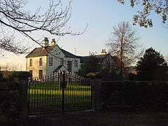 The Old Rectory | |
 Cliburn Cliburn shown within Cumbria | |
| Population | 274 (2011) |
| OS grid reference | NY5824 |
| Civil parish |
|
| District | |
| Shire county | |
| Region | |
| Country | England |
| Sovereign state | United Kingdom |
| Post town | PENRITH |
| Postcode district | CA10 |
| Dialling code | 01931 |
| Police | Cumbria |
| Fire | Cumbria |
| Ambulance | North West |
| EU Parliament | North West England |
| UK Parliament | |
Cliburn is a village and civil parish in the Eden District of Cumbria, England. The civil parish includes the hamlet of Town Head. In 2001 the population was 204,[1] increasing to 274 at the 2011 Census.[2]
History and Geography
Cliburn village is situated at crossroads on the east-west running C3047 (minor road) between Bolton and Penrith and a north-south road connecting Morland in the south to the A66(T). The River Leith runs through the village south of the road. The village was served by Cliburn railway station on the Eden Valley railway line 1 km north of the village, and the village pub was called the Railway Inn, but after the station closed the name was changed to the Golden Pheasant Inn.[3]
The etymology of the name Cliburn comes from clay and burn "clay stream",[4] also interpreted as "Stream by the bank".[5] Cliburn has been known as Cleburn or Cleyburn.[6] Cliburn was historically in Westmorland.
Cliburn Hall
Cliburn Hall,[map 1] a three-storey Pele tower was built in 1387 by Robert de Cliburn. Alterations and additions were made in 1567 by Richard Cliburn. In 1872 the tower was de-castellated, and given a gabled roof.[7] Originally there was an additional square tower at the south side of the building.[8]
A stone inscription from the building reads:
Richard Cleburn this they me called
In which my time hath built this Hall
A.D. 1567
St Cuthbert's Church
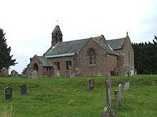
The nave and chancel of St Cuthberts Church date from the 12th century and the church is a Grade II listed building.[9] The church was restored in the 19th century and all the windows except one date from that period.[10][11]
The rectory lies between the village and former railway station.[12]
Other features
Cliburn Bridge, at the south of the village over the River Leith on the road to Morland, and Cliburn Mill Bridge to the east at the confluence of the Leith and the River Lyvennet on the road to Bolton are built of local red sandstone. They were built after 1822 when a powerful flood destroyed the earlier bridges.[13][14]
Cliburn Moss, northwest of the village is a national nature reserve (NNR).[15]
A school was endowed in 1807. The school/house was rebuilt in 1877.[16]
See also
- Listed buildings in Cliburn, Cumbria
- Whinfell Forest is a large wood to the northwest and location of a Centre Parcs UK holiday park.
References
- ↑ Neighbourhood Statistics. "ONS Area: Cliburn CP (Parish)". Neighbourhood.statistics.gov.uk. Retrieved 2011-01-15.
- ↑ "Parish population 2011". Retrieved 22 June 2015.
- ↑ "History of Cliburn Manor and Parish". Cliburn parish. Retrieved 3 January 2018.
- ↑ The history and antiquities of the counties of Westmorland and Cumberland, Volume 1 , Joseph Nicolson, Richard Burn, William Nicolson, Henry Hornyold-Strickland , 1777 , "The Parish of Cliburn" , pp.457-460 , google books
- ↑ Cliburn www.visitcumbria.com
- ↑ "Westmorland - Cliburn". GENUKI. Retrieved 2011-01-15.
- ↑ The Later Records relating to North Westmorland: or the Barony of Appleby , John F. Curwen , 1932 , pp.291-295 , "Cliburn Hall" online via www.british-history.ac.uk
- ↑ Cliburn Hall www.pastscape.org
- ↑ "Church of St Cuthbert - Cliburn - Cumbria - England". British Listed Buildings. 1968-02-06. Retrieved 2011-01-15.
- ↑ Cliburn - St Cuthbert's Church Archived 2010-09-25 at the Wayback Machine. www.visitcumbria.com
- ↑ St Cuthbert's Church, Cliburn www.morlandchurch.org.uk
- ↑ Rectory Farm, House and Adjoining Buildings, Cliburn www.britishlistedbuildings.co.uk
- ↑ The Later Records relating to North Westmorland: or the Barony of Appleby , John F. Curwen , 1932 , pp.291-295 , "Bridges" , online via www.british-history.ac.uk
- ↑ History, topography, and directory, of Westmorland; and Londsdale north of the sands, in Lancashire together with a descriptive and geological view of the whole of the Lake district , P.J. Mannex , 1849 , pp.216-7 , "Cliburn Parish" , google books
- ↑ Cliburn Moss NNR www.naturalengland.org.uk
- ↑ "Parishes (West Ward) - St Cuthbert, Cliburn | British History Online". British-history.ac.uk. 2003-06-22. Retrieved 2011-01-15.
Maps
- ↑ Cliburn Hall, Cliburn, Cumbria 54°36′51″N 2°38′15″W / 54.614292°N 2.637624°W
- ↑ St. Cuthberts, Cliburn, Cumbria 54°36′50″N 2°38′24″W / 54.613859°N 2.639995°W
Further reading
- Westmorland Heritage, Alfred Wainwright, 2006, p. 62 "Cliburn", google book preview
External links
| Wikimedia Commons has media related to Cliburn. |
- Cumbria County History Trust: Cliburn (nb: provisional research only - see Talk page)
- Cliburn www.visitoruk.com
Cumbria Portal | |
| Boroughs or districts | |
| Major settlements |
|
| Topics | |