Montes de Oca (canton)
| Montes de Oca | ||
|---|---|---|
| Canton | ||
 Fuente de la Hispanidad and Mall San Pedro (right) | ||
| ||
| Motto(s): Cuna de la Educación Superior (Cradle of Higher Education) | ||
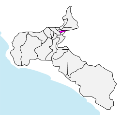 Montes de Oca canton in San José province | ||
| Coordinates: 09°56′28″N 84°00′34″W / 9.94111°N 84.00944°WCoordinates: 09°56′28″N 84°00′34″W / 9.94111°N 84.00944°W | ||
| Country | Costa Rica | |
| Province | San José | |
| Established | August 2, 1915 | |
| Named for | Don Faustino Montes de Oca | |
| Capital | San Pedro | |
| Districts |
4 districts (distritos)
| |
| Government | ||
| • Mayor[1] | Marcel Soler Rubio (Coalición Gente de Montes de Oca) | |
| Area | ||
| • Total | 15.16 km2 (5.85 sq mi) | |
| Elevation | 1,205 m (3,953 ft) | |
| Population (2010)[2] | ||
| • Total | 54,288 | |
| • Density | 3,600/km2 (9,300/sq mi) | |
| Time zone | UTC-6 | |
| Website | www.montesdeoca.go.cr | |
Montes de Oca is the 15th canton in the province of San José in Costa Rica. The canton covers an area of 15.16 square kilometres (5.85 sq mi),[3] and has a population of 54,288.[4] The capital city of the canton is San Pedro.
The elongated canton reaches from the suburbs of the national capital of San José eastward to the province of Cartago, and neighbors the cantons of Curridabat, San José, Cartago, and Goicoechea. The Río Torres delineate a portion of the northern boundary, while the Río Ocloro and Quebrada Poró mark the southern boundary.
The canton is known for its high level of commercial development, the number of universities and other centers of higher education, and its active night life. It is one of the most urbanized and vibrant cantons in the San José area, both day and night.
Montes de Oca ranks first in the Costa Rican cantonal HDI, with 0,946.
Districts
The canton of Montes de Oca is subdivided into four districts (distritos):[5]
| District | Postal code | Alt. (m) | Area (km2) | Pop. (2008) | Coordinates |
|---|---|---|---|---|---|
| San Pedro | 11501 | 1,205 | 4.82 | 29,245 | 09°56′02″N 84°03′16″W / 9.93389°N 84.05444°W |
| Barrios (neighborhoods): Alhambra, Azáleas, Carmiol, Cedral, Dent (part), Francisco Peralta (part), Fuentes, Granja, Kezia, Lourdes, Monterrey, Nadori, Oriente, Pinto, Prados del Este, Roosevelt, San Gerardo (part), Santa Marta, Saprissa, Vargas Araya, Yoses | |||||
| Sabanilla | 11502 | 1,305 | 1.79 | 12,944 | 09°56′48″N 84°02′11″W / 9.94667°N 84.03639°W |
| Barrios (neighborhoods): Arboleda, Bloquera, Cedros, El Cristo (part), Españolita, Luciana, Marsella, Maravilla, Rodeo, Rosales, San Marino | |||||
| Mercedes | 11503 | 1,200 | 1.39 | 5,063 | 09°56′28″N 84°03′12″W / 9.94111°N 84.05333°W |
| Barrios (neighborhoods): Betania, Alma Máter, Damiana, Dent (part), Guaymí, Paso Hondo, Paulina, Profesores | |||||
| San Rafael | 11504 | 1,340 | 7.16 | 8,562 | 09°56′42″N 84°01′08″W / 9.94500°N 84.01889°W |
| Barrios (neighborhoods): Alameda, Andrómeda, Begonia, Cuesta Grande (part), El Cristo (parte), Estéfana (part), Europa, Liburgia, Mansiones (part), Maruz, Salitrillos | |||||
Education
Montes de Oca is known in Costa Rica as the Cradle of Higher Education as it is home to the University of Costa Rica as well as other university-level centers of study, such as the Universidad Latina and the Universidad Americana (UAM) Escuela Laboratorio. The canton can boast of 99% literacy, compared with 95% in Costa Rica at large.
Points of interest
- Fuente de la Hispanidad (Spanishness's Fountain), a large fountain in a major roundabout built in the mid-80s that focuses on Costa Rica's cultural heritage. It is a major landmark in the area.
- Mall San Pedro, a shopping center built in the mid-90s, contains tattoo parlors, a movie theater, a food court, video game shops, and clothing stores.
- Iglesia de San Pedro (San Pedro Catholic Church)
- Calle de la Amargura (Bitterness Street) a street centered around the nightlife of the University of Costa Rica.
History
The canton was established by law on August 2, 1915. Its name honors a former congressional representative from the area, Don Faustino Montes de Oca (1859–1902).
References
- ↑ "Lista de alcaldes electos 2010 - 2016 en los comicios municipales" [List of mayors elected 2010 - 2016 in the municipal elections] (in Spanish). El País. 06/12/2010. Archived from the original on 2010-12-09. Check date values in:
|date=(help) - ↑ "Montes de Oca, San José" (PDF) (in Spanish). Instituto de Formacion y Estudios en Democracia. Archived from the original (PDF) on 2012-03-28.
- ↑ Instituto Geográfico Nacional (IGN), 2001.
- ↑ Estimates of Instituto Nacional de Estadística y Censos (INEC), 2010.
- ↑ "División Territorial Administrativa de Costa Rica" (PDF) (in Spanish). Instituto de Fomento y Asesoria Municipal (IFAM). 5 May 2009. Archived from the original (PDF) on 2 August 2015.
External links
- Montes de Oca, official site