Curridabat
Coordinates: 09°54′49″N 84°02′20″W / 9.91361°N 84.03889°W
| Curridabat | ||
|---|---|---|
| ||
| Nickname(s): Curri | ||
| Coordinates: 09°56′N 84°05′W / 9.933°N 84.083°W | ||
| Country | Costa Rica | |
| Province | San José Province | |
| Canton | Curridabat | |
| District | Curridabat | |
| Founded | 1929 | |
| Government | ||
| • Syndic | Ana Lucía Ferrero Mata (Curridabat Siglo XXI) | |
| • Substitute syndic | Álvaro Enrique Chaves Lizano | |
| Area | ||
| • Total | 6.48 km2 (2.50 sq mi) | |
| Elevation | 1,208 m (3,963 ft) | |
| Population (2012) | ||
| • Total | 32,443 | |
| • Density | 5,000/km2 (13,000/sq mi) | |
| • Demonym | Curridabatense | |
| Time zone | UTC-6 (Central Standard Time) | |
| Postal code | 11800 | |
| Area code(s) | + 506 | |
| Website | http://www.curridabat.go.cr | |
Curridabat is a city of the San José Province in Costa Rica.
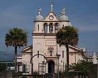
Catholic church in downtown Curridabat
It is situated on the eastern border of the city, San José, above the Desamparados Canton, and below the Montes de Oca Canton.
Curridabat has a population of around 34,000 people. This city is part of the canton of Curridabat which has four districts: Curridabat, Granadilla, Sanchez, and Tirrases.
External links
- General information about Curridabat, including maps (in Spanish)
- Government site (in Spanish)
| Wikimedia Commons has media related to Curridabat. |
This article is issued from
Wikipedia.
The text is licensed under Creative Commons - Attribution - Sharealike.
Additional terms may apply for the media files.