Curridabat (canton)
| Curridabat | ||
|---|---|---|
| Canton | ||
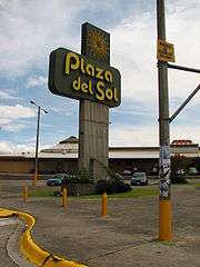 Plaza del Sol commercial center | ||
| ||
| Nickname(s): Curri | ||
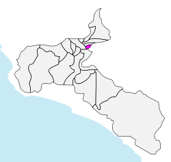 Curridabat canton in San José province | ||
| Coordinates: 09°56′N 84°05′W / 9.933°N 84.083°WCoordinates: 09°56′N 84°05′W / 9.933°N 84.083°W | ||
| Country | Costa Rica | |
| Province | San José | |
| Established | August 21, 1929 | |
| Districts |
4 districts (distritos)
| |
| Government | ||
| • Mayor[1] | Édgar Mora Altamirano (Partido Curridabat Siglo XXI) | |
| Area | ||
| • Total | 15.95 km2 (6.16 sq mi) | |
| Elevation | 1,208 m (3,963 ft) | |
| Population (2010)[2] | ||
| • Total | 72,564 | |
| • Density | 4,500/km2 (12,000/sq mi) | |
| Time zone | UTC-6 (Central Standard Time) | |
| Website | www.curridabat.go.cr | |

Curridabat is the 18th canton in the province of San José in Costa Rica. The canton covers an area of 15.95 square kilometres (6.16 sq mi),[3] and has a population of 72,564 (estimate as of 2010).[4] The capital city of the canton is also called Curridabat.
The canton forms a suburb of the national capital of San José, lying on the southeast edge of the city.
Location
The city is located southeast of the city of San José and its limits are:
- East:La Unión
- West:San José
- North:Montes de Oca
- South:Desamparados
Districts
The canton of Curridabat is subdivided into four districts (distritos):[5]
| District | Postal code | Alt. (m) | Area (km2) | Pop. (2008) | Coordinates |
|---|---|---|---|---|---|
| Curridabat | 11801 | 1,208 | 6.48 | 34,073 | 09°54′58″N 84°02′22″W / 9.91611°N 84.03944°W |
| Barrios (neighborhoods): Ahogados (part), Aromático, Cipreses, Chapultepec, Dorados, Guayabos, Hacienda Vieja, Hogar, José María Zeledón, Laguna, La Lía, Mallorca, María Auxiliadora, Miramontes, Nopalera, Plaza del Sol, Prado, San José, Santa Cecilia, Tacaco | |||||
| Granadilla | 11802 | 1,343 | 3.41 | 13,214 | 09°56′11″N 84°00′53″W / 9.93639°N 84.01472°W |
| Barrios (neighborhoods): Biarquiria, Eucalipto, Freses, Granadilla Norte, Granadilla Sur, Montaña Rusa (part) | |||||
| Sánchez | 11803 | 1,250 | 4.17 | 3,470 | 09°54′47″N 84°01′06″W / 9.91306°N 84.01833°W |
| Barrios (neighborhoods): Araucauria (part), Lomas de Ayarco, Pinares | |||||
| Tirrases | 11804 | 1,175 | 1.89 | 18,717 | 09°54′27″N 84°02′22″W / 9.90750°N 84.03944°W |
| Barrios (neighborhoods): Colina, Lomas de San Pancracio, Ponderosa, Quince de Agosto | |||||
History
The canton was established by law on August 21, 1929.
In 1930 the canton had a municipality with three regidores, a Major (AKA Ejecutivo Municipal) and Jefe político (both charges were in the same person). At this time the canton's population were 5,000 people, but with the time and the population grew and the municipality had to create a sanitation department to collect garbage, road, sidewalk maintenance and built some infrastructure. Then the municipality Council was expanded to five members by popular election in 1970.
Points of interest
- Plaza del Sol (Sun's Plaza) a shopping center built in the early 80s. At the time it was the most modern shopping center in the city. Today, it has many customers ranging from middle to high class.
- Multiplaza del Este (Eastern Multiplaza), now Multiplaza Curridabat is a mall built between mid-2002 and late 2003 that belongs to the commercial chain with the same name and have other malls in Central America. It has food court, cinemas and stores. It is located in the old establishment of Republic Tobacco Co.
- San José Indoor Club, it is a recreational sports club for the middle and high class in San José.
Notable residents
- Rafael Ángel Calderón Fournier, former president, lives in Pinares; also son of former president Rafael Ángel Calderón Guardia
- Karen Olsen Beck, wife of former president José Figueres Ferrer; also mother of former president José Figueres Olsen
References
- ↑ "Lista de alcaldes electos 2010 - 2016 en los comicios municipales" [List of mayors elected 2010 - 2016 in the municipal elections] (in Spanish). El País. 06/12/2010. Archived from the original on 2010-12-09. Check date values in:
|date=(help) - ↑ "Curridabat, San José" (PDF) (in Spanish). Instituto de Formacion y Estudios en Democracia. Archived from the original (PDF) on 2012-03-28.
- ↑ Instituto Geográfico Nacional (IGN), 2001.
- ↑ Estimates of Instituto Nacional de Estadística y Censos (INEC), 2010.
- ↑ "División Territorial Administrativa de Costa Rica" (PDF) (in Spanish). Instituto de Fomento y Asesoria Municipal (IFAM). 5 May 2009. Archived from the original (PDF) on 2015-08-02.
External links
- Curridabat, official site