Bagaces (canton)
Coordinates: 10°32′N 85°15′W / 10.533°N 85.250°W
| Bagaces | |
|---|---|
| Cantón | |
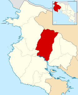 Location of Bagaces Canton in Guanacaste Province | |
| Country | Costa Rica |
| Province | Guanacaste |
| Area | |
| • Total | 1,273.49 km2 (491.70 sq mi) |
| Population (2013) | |
| • Total | 21,567 |
| • Density | 17/km2 (44/sq mi) |
Bagaces is the fourth canton in the province of Guanacaste in Costa Rica. The canton covers an area of 1,273.49 km²,[1] and has a population of 17,087.[2] Its capital city is also called Bagaces.
The Río Salto on the west and Río Tenorio on the east delineate this canton, with the Río Tempisque as the southern border and the northern border high in the Cordillera de Guanacaste. Miravalles Volcano sits near that border's midway point.
Districts
The canton of Bagaces is subdivided into four districts (distritos):
| District | Population |
|---|---|
| Bagaces | 13,791 |
| La Fortuna | 2,900 |
| Mogote | 3,777 |
| Río Naranjo | 1,099 |
History
Bagaces was first mentioned as a canton in a decree dated December 7, 1848.
References
External links
- "Bagaces Canton Map" Instituto de Fomento y Asesoría Municipal, 1985
- "Bagaces Google Satellite Map" Maplandia
This article is issued from
Wikipedia.
The text is licensed under Creative Commons - Attribution - Sharealike.
Additional terms may apply for the media files.