Nandayure (canton)
| Nandayure | |
|---|---|
| Cantón | |
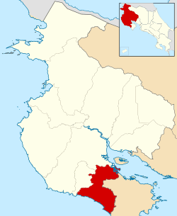 Location of Nandayure Canton in Guanacaste Province | |
| Country | Costa Rica |
| Province | Guanacaste |
| Area | |
| • Total | 565.59 km2 (218.38 sq mi) |
| Population (June 2013) | |
| • Total | 11,453 |
| • Density | 20/km2 (52/sq mi) |
Nandayure is the ninth canton in the province of Guanacaste in Costa Rica. The canton covers an area of 565.59 km²,[1] and has a population of 11,453.[2] Its capital town is Carmona.
The canton encompasses a piece of the coastline of the Gulf of Nicoya near the mouth of the Río Tempisque, including Isla Berrugate. It cuts across the center of the Nicoya Peninsula to the Pacific coast between the Río Ora to the north and the Río Bongo to the south.
Districts
The canton of Nandayure is subdivided into six districts (distritos):
| District | Population |
|---|---|
| Carmona | 2,451 |
| Santa Rita | 1,438 |
| Zapotal | 1,242 |
| San Pablo | 2,268 |
| Porvenir | 763 |
| Bejuco | 3,291 |
History
The canton was established by law on October 9, 1961.
On September 5, 2012, Nandayure was struck by a magnitude 7.6 earthquake, destroying houses in the canton.[3][4]
References
- ↑ Instituto Geográfico Nacional (IGN), 2001.
- ↑ Estadísticas Vitales 2013 Archived 2015-04-02 at the Wayback Machine. - INEC
- ↑ "M7.6 - 12km ENE of Hojancha, Costa Rica". United States Geological Survey. September 5, 2012. Retrieved October 3, 2012.
- ↑ Mata Blanco, Alonso (September 6, 2012). "Sismo Destruyó Viviendas en Varios Cantones de Guanacaste y Alajuela" [Earthquake Destroyed Homes in Several Cantons of Guanacaste and Alajuela]. La Nación (in Spanish). Archived from the original on September 25, 2012. Retrieved October 3, 2012.
Coordinates: 10°00′N 85°15′W / 10.000°N 85.250°W
This article is issued from
Wikipedia.
The text is licensed under Creative Commons - Attribution - Sharealike.
Additional terms may apply for the media files.