Monteleone Sabino
| Monteleone Sabino | ||
|---|---|---|
| Comune | ||
| Comune di Monteleone Sabino | ||
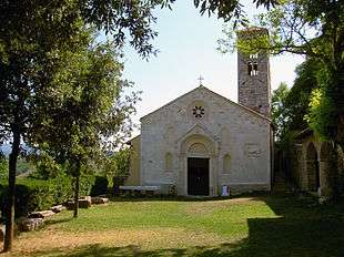 Santa Vittoria Shrine. | ||
| ||
 Monteleone Sabino Location of Monteleone Sabino in Italy | ||
| Coordinates: 42°14′N 12°51′E / 42.233°N 12.850°E | ||
| Country | Italy | |
| Region | Latium | |
| Province | Rieti (RI) | |
| Frazioni | Ginestra Sabina | |
| Government | ||
| • Mayor | Angelo Paolo Marcari | |
| Area | ||
| • Total | 18.8 km2 (7.3 sq mi) | |
| Elevation | 496 m (1,627 ft) | |
| Population (30 November 2017)[1] | ||
| • Total | 1,231 | |
| • Density | 65/km2 (170/sq mi) | |
| Demonym(s) | Monteleonesi | |
| Time zone | UTC+1 (CET) | |
| • Summer (DST) | UTC+2 (CEST) | |
| Postal code | 02033 | |
| Dialing code | 0765 | |
| Website | Official website | |

Monteleone Sabino is a comune (municipality) in the Province of Rieti in the Latium region of Italy, located about 45 kilometres (28 mi) northeast of Rome and about 20 kilometres (12 mi) south of Rieti.
Main sights
- The remains of the ancient Sabine town of Trebula Mutusca are located in Monteleone's territory;
- The 12th century Romanesque Santa Vittoria shrine, which left side was rebuilt during the 15th century.
Twin towns

References
External links
| Wikimedia Commons has media related to Monteleone Sabino. |
This article is issued from
Wikipedia.
The text is licensed under Creative Commons - Attribution - Sharealike.
Additional terms may apply for the media files.