Rocca Sinibalda
| Rocca Sinibalda | ||
|---|---|---|
| Comune | ||
| Comune di Rocca Sinibalda | ||
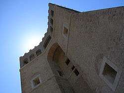 The Sforza Cesarini Castle. | ||
| ||
 Rocca Sinibalda Location of Rocca Sinibalda in Italy | ||
| Coordinates: 42°16′N 12°56′E / 42.267°N 12.933°ECoordinates: 42°16′N 12°56′E / 42.267°N 12.933°E | ||
| Country | Italy | |
| Region | Lazio | |
| Province | Rieti (RI) | |
| Frazioni | Magnalardo, Pantana, Posticciola, Tomassella, Torricchia, Trampani, Vallecupola | |
| Government | ||
| • Mayor | Stefano Micheli | |
| Area | ||
| • Total | 49.56 km2 (19.14 sq mi) | |
| Elevation | 552 m (1,811 ft) | |
| Population (31 December 2010)[1] | ||
| • Total | 844 | |
| • Density | 17/km2 (44/sq mi) | |
| Demonym(s) | Rocchegiani | |
| Time zone | UTC+1 (CET) | |
| • Summer (DST) | UTC+2 (CEST) | |
| Postal code | 02026 | |
| Dialing code | 0765 | |
| Website | Official website | |

Rocca Sinibalda is a comune (municipality) in the Province of Rieti in the Italian region Lazio, located about 50 kilometres (31 mi) northeast of Rome and about 15 kilometres (9 mi) southeast of Rieti.
It is home to the Sforza Cesarini Castle, originally built in 1084 but turned into a more modern fortress in the 1530s by Baldassare Peruzzi, commissioned by Cardinal Alessandro Cesarini. The interior has frescoes from the 17th and 18th centuries.
The remains of the ancient Sabine town of Trebula Mutusca are not far.
References
This article is issued from
Wikipedia.
The text is licensed under Creative Commons - Attribution - Sharealike.
Additional terms may apply for the media files.