Tarano
| Tarano | |
|---|---|
| Comune | |
| Comune di Tarano | |
 Tarano | |
 Tarano Location of Tarano in Italy | |
| Coordinates: 42°21′N 12°36′E / 42.350°N 12.600°ECoordinates: 42°21′N 12°36′E / 42.350°N 12.600°E | |
| Country | Italy |
| Region | Latium |
| Province | Province of Rieti (RI) |
| Area | |
| • Total | 20.1 km2 (7.8 sq mi) |
| Elevation | 234 m (768 ft) |
| Population (Dec. 2004) | |
| • Total | 1,296 |
| • Density | 64/km2 (170/sq mi) |
| Time zone | UTC+1 (CET) |
| • Summer (DST) | UTC+2 (CEST) |
| Postal code | 02040 |
| Dialing code | 0765 |
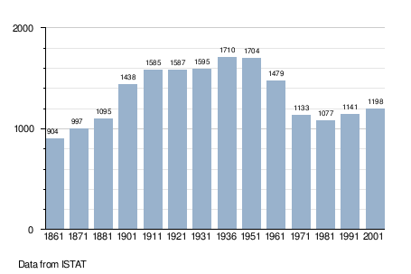
Tarano is a comune (municipality) in the Province of Rieti in the Italian region Latium, located about 50 kilometres (31 mi) north of Rome and about 25 kilometres (16 mi) west of Rieti. As of 31 December 2004, it had a population of 1,296 and an area of 20.1 square kilometres (7.8 sq mi).[1]
Tarano borders the municipalities of Collevecchio, Forano, Montebuono, Selci, Stimigliano, and Torri in Sabina.
Demographic evolution
References
This article is issued from
Wikipedia.
The text is licensed under Creative Commons - Attribution - Sharealike.
Additional terms may apply for the media files.