Micigliano
| Micigliano | |
|---|---|
| Comune | |
| Comune di Micigliano | |
 Micigliano Location of Micigliano in Italy | |
| Coordinates: 42°27′N 13°3′E / 42.450°N 13.050°ECoordinates: 42°27′N 13°3′E / 42.450°N 13.050°E | |
| Country | Italy |
| Region | Latium |
| Province | Province of Rieti (RI) |
| Area | |
| • Total | 37.8 km2 (14.6 sq mi) |
| Elevation | 925 m (3,035 ft) |
| Population (Dec. 2004) | |
| • Total | 146 |
| • Density | 3.9/km2 (10/sq mi) |
| Time zone | UTC+1 (CET) |
| • Summer (DST) | UTC+2 (CEST) |
| Postal code | 02010 |
| Dialing code | 0746 |
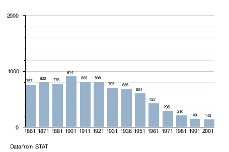
Micigliano is a comune (municipality) in the Province of Rieti in the Italian region Latium, located about 80 kilometres (50 mi) northeast of Rome and about 15 kilometres (9 mi) northeast of Rieti. As of 31 December 2004, it had a population of 146 and an area of 37.8 square kilometres (14.6 sq mi).[1]
Micigliano borders the following municipalities: Antrodoco, Borbona, Borgo Velino, Cantalice, Castel Sant'Angelo, Cittaducale, Leonessa, Posta, Rieti.
Demographic evolution
References
This article is issued from
Wikipedia.
The text is licensed under Creative Commons - Attribution - Sharealike.
Additional terms may apply for the media files.