Santa Vittoria in Matenano
| Santa Vittoria in Matenano | ||
|---|---|---|
| Comune | ||
| Comune di Santa Vittoria in Matenano | ||
 | ||
| ||
 Santa Vittoria in Matenano Location of Santa Vittoria in Matenano in Italy | ||
| Coordinates: 43°1′N 13°30′E / 43.017°N 13.500°E | ||
| Country | Italy | |
| Region | Marche | |
| Province | Fermo (FM) | |
| Frazioni | Ponte Maglio | |
| Government | ||
| • Mayor | Fabrizio Vergari | |
| Area | ||
| • Total | 26.18 km2 (10.11 sq mi) | |
| Elevation | 626 m (2,054 ft) | |
| Population (31 December 2016)[1] | ||
| • Total | 1,321 | |
| • Density | 50/km2 (130/sq mi) | |
| Demonym(s) | Santavittoriesi | |
| Time zone | UTC+1 (CET) | |
| • Summer (DST) | UTC+2 (CEST) | |
| Postal code | 63028 | |
| Dialing code | 0734 | |
| Patron saint | St. Victoria | |
| Saint day | 20 June | |
| Website | Official website | |

| Wikimedia Commons has media related to Santa Vittoria in Matenano. |
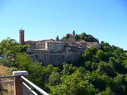
Santa Vittoria in Matenano is a comune (municipality) in the Province of Fermo in the central Italian region Marche, located about 70 kilometres (43 miles) south of Ancona and about 20 km (12 mi) northwest of Ascoli Piceno.
Its name refers to Saint Victoria, some of whose relics were transferred in 827 by Abbot Peter of Farfa from the Abbey to Mount Matenano in the Picene area (roughly the south of Le Marche) due to Saracen invasions.[2] Ratfredus, a later Abbot of Farfa, brought the body of Santa Vittoria from Farfa on 20 June 931.
International relations
Twin towns — Sister cities
Santa Vittoria in Matenano is twinned with:
|
|
Photos
- www.flickr.com/photos/21899366@N07/sets/72157622532347787/
References
- ↑ All demographics and other statistics: Italian statistical institute Istat.
- ↑ Santa Vittoria
This article is issued from
Wikipedia.
The text is licensed under Creative Commons - Attribution - Sharealike.
Additional terms may apply for the media files.