Monte Penna
| Monte Penna | |
|---|---|
 | |
| Highest point | |
| Elevation | 1,735 m (5,692 ft) [1] |
| Coordinates | 44°28′52.9″N 9°29′34.1″E / 44.481361°N 9.492806°E |
| Geography | |
 Monte Penna Location in Italy | |
| Location | Liguria/Emilia-Romagna, Italy |
| Parent range | Ligurian Appennines |
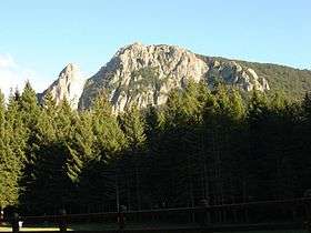
Monte Penna is a mountain (1,735 m) on the border between Liguria and Emilia-Romagna, northern Italy, part of the Ligurian Appennines. It is included in the Natural Regional Park of the Aveto, and overlooks the Val di Taro; the sources of both the Taro and Ceno Rivers are located in Monte Penna's slope.
The name derives from the ancient Celtic deity Penn, who was believed to reside here by the Ligures.
References
- ↑ Marco Salvo and Daniele Canossini (2003). Appennino ligure e tosco-emiliano. Club Alpino Italiano and Touring Club Italiano. p. 154. ISBN 8836527752.
External links
This article is issued from
Wikipedia.
The text is licensed under Creative Commons - Attribution - Sharealike.
Additional terms may apply for the media files.