Mongkawng
- Not to be confused with Mogaung in Mingin Township
| Mongkawng State (Möngkawng) | |||||
| State of the Shan States | |||||
| |||||
 | |||||
| History | |||||
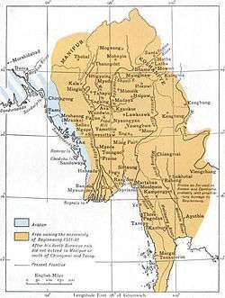
| • | Möngkawng state established | 1215 | |||
| • | Annexed by the Kingdom of Burma | 1796 | |||
| Today part of | Myitkyina District, Myanmar | ||||
Mogaung or Möngkawng (Burmese: မိုးကောင်း) was a Shan state in what is today Burma. It was an outlying territory, located away from the main Shan State area in present-day Kachin State. The state existed until 1796. The main town was Mogaung (Mong Kawng).
History
According to legend a predecessor state named Udiri Pale had been established in 58 BC. The area was said to have been inhabited by the Tai Long. According to Tai chronicles the kingdom was founded in 1215 by a saopha named Sam Long Hpa who ruled over an area stretching from Hkamti Long to Shwebo.[1]
Möngkawng (Mong Yang) was occupied by China between 1479 and 1483, after regaining independence it was again briefly occupied by China in 1495. From 1651 to 1742 the state was occupied by the Ava-based Kingdom of Burma and following a period of less than thirty years it was again occupied by Burma from 1771 to 1775. Finally Möngkawng was annexed by the Ava Kingdom in 1796.[2]
After becoming part of Burma Möngkawng was ruled by administrators named wuns. During British rule in Burma it became part of the Myitkyina District of the Mandalay Division.[3]
Rulers
The rulers of the state bore the title Saopha.
Saophas
- 1663 - 1673 Sui Yaw
- 1673 - 1729 Sui Kyek
- 1729 - 1739 Hum
- 1739 - 1748 Haw Seing (1st time) (d. 1777)
- 1748 - 1765 Haw Kam
- 1765 - 1768 Haw Seing (2nd time) (s.a.)
- 1768 - 1771 Maung Kiaw
- 1771 - 1775 Maung Piu (d. 1775)
- 1775 - 1785 Vacant
- 1785 - 1796 Yaw Pan Kyung
References
- ↑ Imperial Gazetteer of India, v. 18, p. 137. - Myitkyina District, History
- ↑ Shan (Tai) States
- ↑ Nisbet, John (1901). Burma Under British Rule—and Before. 1. Archbald Constable & Company.
External links
Coordinates: 25°18′N 96°56′E / 25.300°N 96.933°E