Mayapa–Canlubang Cadre Road
| Mayapa–Canlubang Cadre Road | |
|---|---|
 | |
| Route information | |
| Maintained by Department of Public Works and Highways - Laguna 2nd District Engineering Office | |
| Length | 2.768 km (1.720 mi) |
| Component highways | |
| Major junctions | |
| West end | Jose Yulo, Sr. Avenue/Silangan Industrial Park Road |
| |
| East end |
|
| Location | |
| Provinces | Laguna |
| Major cities | Calamba |
| Highway system | |
|
Roads in the Philippines | |
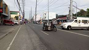
Mayapa–Canlubang Cadre Road is a two-to-four tertiary national road, located in Calamba, Laguna. The 2.768-kilometer[1] road starts in "Checkpoint" area in barangay Paciano Rizal corner Manila South Road and ends upon entering barangay Canlubang joining Jose Yulo Sr Avenue and Silangan Industrial Park Road. The road is also the location of the Canlubang Exit (Exit 47) of the South Luzon Expressway.[2]
Mayapa–Canlubang Cadre Road was reclassified from being a local road into a national road in 2015.[3]
Landmarks
 Mary Help of Christians Parish (located in Mayapa)
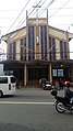
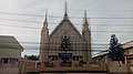 Iglesia ni Cristo–Mayapa Church
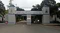 Camp Bgen Vicente P. Lim Gate 1
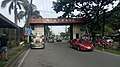 Barangay Canlubang welcome arch denotes the west end of Mayapa–Canlubang Cadre Road
References
- ↑ "Newly Reclassified Local Roads into National Roads in 2015". www.dpwh.gov.ph. Retrieved 2018-09-04.
- ↑ "DPWH Road Data | Laguna 2nd". Department of Public Works and Highways Website. DPWH. Retrieved 2018-09-04.
- ↑ "Declaring the Whole Stretch of Mayapa–Canlubang Cadre Road as a National Road Under the Jurisdiction of Laguna 2nd District Engineering Office, Region IV-A" (PDF). Department of Public Works and Highways Website. DPWH. Retrieved 2018-09-04.
This article is issued from
Wikipedia.
The text is licensed under Creative Commons - Attribution - Sharealike.
Additional terms may apply for the media files.