Mauch Chunk Switchback Railway
|
Mauch Chunk Railroad Summit Hill & Mauch Chunk Railroad Mauch Chunk and Summit Hill Switchback Railroad | |
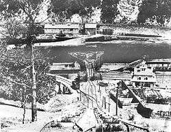 Looking down at the Lehigh Canal landing, circa 1870.  Pisgah Mountain and the topography of the Summit Hill and Mauch Chunk Railroad | |
  | |
| Location | Between Ludlow St. in Summit Hill and F.A.P. 209 in Jim Thorpe, Carbon County, Pennsylvania |
|---|---|
| Coordinates | 40°52′10″N 75°44′59″W / 40.86944°N 75.74972°WCoordinates: 40°52′10″N 75°44′59″W / 40.86944°N 75.74972°W |
| Area | 47 acres (19 ha) |
| Built | 1827, improved 1830s |
| Built by | Lehigh Coal & Navigation Co. (LC&N) |
| Architect | Josiah White |
| NRHP reference # | 76001616[1] |
| Significant dates | |
| Added to NRHP | June 3, 1976 |
| Designated PHMC | May 25, 1971[2] |
_Erskine_Hazard_(1790-1865).jpg)
The Mauch Chunk and Summit Railroad was a coal hauling railroad in the mountains of Pennsylvania that operated between 1828 and 1932. It was also the first operational US railway of any substantial length to carry paying passengers.
A private line which moved coal for the Lehigh Coal & Navigation Company on 3 foot 6 inch gauge track, it was not a common carrier which linked with other railroads. The rail line was laid on top of the company's earlier 9 miles (14 km)-constant-descent-graded wagon road and trains would run for over a hundred years until the middle days of the Great Depression.
Pennsylvania's first railroad and first anthracite carrier opened on Saturday, May 5th, 1827, when seven cars of coal passed from the Summit Hill mines of the L.C.&N. Company to their canal at Mauch Chunk, descending 936 feet in the nine-mile trip.[3]
— Earl J. Heydinger
It was the second operational (permanent)[lower-alpha 1] United States railroad,[lower-alpha 2] the first over five miles long, and like its rival B&O Railroad, Mauch Chunk began using humble animal power to return its coal tub consists up to the summit—the mules were sent down in the last batch of cars and the return trip required 4-5 hours.
Subsequently, the road would send down groups of 6–8 coal cars under control of a brakeman, and once 40–42 cars were down, send down the special "mule cars" with the draft animals, thus having just enough animals to return all cars back to the top.[lower-alpha 3] so became a combined gravity-incline plane combination railway with two steep cable railroad lift sections. A powered double-incline plane road led up to the top of two separate summits along Pisgah Ridge on the return leg and each summit had "a new down track" returning the cars several miles farther west in each case.[5] This saw-tooth elevation profile gave the new return track a swooping characteristic ride later deliberately designed into roller coasters. About the same time, when other mine heads were opened in lower elevations of the Panther Creek Valley LC&N added several descending switchback sections and other shorter cable railway climbing inclines to bring the coal up from the new Lansford and Coaldale mines[lower-alpha 4] to the Summit Hill loading area for the gravity railway trip down to Mauch Chunk, thence to the Lehigh Canal (and in 1855, by rail transport) and their clamoring customers. The railroad became an early American tourist attraction and is considered the world's first roller coaster, a role it would keep and satisfy with tourists for over five decades after it was abandoned as a primary freight railroad.
.jpg)
Bodmer's painting is quite likely viewed from land leveled and cleared for the Beaver Meadow Railroad then under construction on the Lehigh's left bank. The viewpoint of the picture is very near where the Lehigh's left bank abutment anchors the railbridge crossing the stream as both the railbed and river exit the gorge opposite Nesquehoning Creek's mouth.
Having had an eye for high-tech from the outset, the LC&N company's founders decided to try some of the railroad solutions put into place in England around County Durham, who were early adopters of not only railroads, but both the steam locomotive and stationary steam Winding engine. At first gravity powered with mules returning the empties, the line was converted to cable haulage with stationary steam engines atop the summit in 1846.
In 1846, the railroad responded to increasing demand for coal[6] and the poor logistics of a single-track route by building a new up track consisting of two steam-powered, Josiah White engineered 120 horsepower (89 kW) funicular systems to replace the use of mules.[7] These 'Planes' (incline planes) used two clever telescoping wheeled Barney pusher cars attached to the cables by springy steel tow-bands running between two large diameter winch wheels[lower-alpha 5] located in the barney tunnels. When a car was readied for an ascent, it was drifted down the slight incline from above and behind the barney tunnel to wait at a latch. The barneys came up and coupled behind to push the cars up the hill. One of the inclines rose 664 feet (202 m) up Mount Pisgah,[6] and the other crossed Mount Jefferson. The downhill trip continued to be powered by gravity, as did the downhill portions of the otherwise uphill direction.[8] The up track was equipped with a ratchet[lower-alpha 6] which would prevent a car that detached from the cable from running away down hill.[7] This invention later evolved into the anti-rollback device used on roller coasters.[6] This was also when the railroad extended its name to the Mauch Chunk, Summit Hill and Switchback Railroad.[7] The modernization of the railroad reduced a passenger round-trip from 4.5 hours to just 80 minutes.[6]
In 1872, the Panther Creek Railroad opened as a replacement for the switchback line.
The Lehigh Coal and Railroad is considered the first American company to use vertical integration—providing raw materials, shipping, processing and final goods.
Some famous personalities who visited the railroad include Prince Maximilian of Wied, President Ulysses S. Grant, William Astor (son of John Jacob Astor), and Thomas Edison.[9] The Central Railroad of New Jersey (CNJ) purchased it in 1874 and leased it to brothers Theodore and H. L. Mumford who operated the line as a tourist attraction. On May 24, 1929, the CNJ sold the line to the new Mauch Chunk Switchback Railway Company, which operated until 1932, when the line fell victim to the Great Depression. The mortgage on the property foreclosed and it was sold to scrapper Isaac Weiner for $18,000 (equal to $322,859 today).[7]
In 1976, a 47-acre (19 ha) section of the former right-of-way, from Ludlow St. in Summit Hill to F.A.P. 209 in Jim Thorpe, was listed on the National Register of Historic Places as "Mauch Chunk and Summit Hill Switchback Railroad". The listed area included four contributing sites.[1]
The right-of-way is now the Switchback Railroad Trail,[10] but efforts are underway to rebuild the Mt. Pisgah incline portion of the route.[11]
See also
- Lehigh Coal and Navigation Company Records in Beyond Steel: An Archive of Lehigh Valley Industry and Culture.
- Early Mining Pictures – Anthracite Mining pictorial: Mines & Structures operated by the L.C.& N., Summit Hill, Lansford and Coaldale, Pennsylvania.
- Switch-Back Gravity Railroad: Proprietary photos touring the LC&N built Summit Hill & Mauch Chunk Railroad, the 2nd railway in North America
Notes
- ↑ Architect/Superintendent Charles Bulfinch in building the Massachusetts State House in 1795, and again in 1805 used a temporary funicular railroad to remove hill tops and overburden from the steeper heights of the original peninsula on which the City of Boston is built.
- ↑ Heydinger's ' traces American railway uses through two temporary furnicular railways (using the same equipment) which was used to relocate overburden and foundation materials, as well as two peaks when Boston was filling in its Back Bay neighborhood and reshaping Beacon Hill—which had three summits when the series of projects began.
- ↑ The earliest documented pleasure riders were in 1827 by visitors out to admire the new railway technology. This gives rise to the credit of the railway as the first roller coaster.
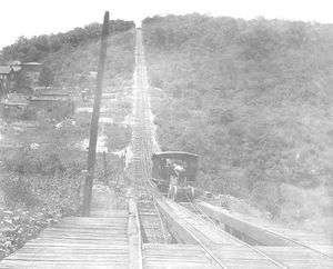 The 'Up Route' cable Railway addition of 1846-47 that topped the 1,000 feet (300 m) Mount Pisgah summit as it rose over 664 feet (202 m) over a length of 2,322 feet (708 m)[4] from the upper plateau area and the loading chutes near the dock above Mauch Chunk (Jim Thorpe) to top the summit dominating the town and river close below.
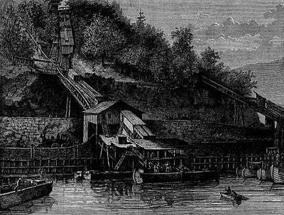
• Once atop Mount Pisgah, the cars swooped nearly five miles to a second cable incline in a similar coupling area as that shown here.
• The "Barney" pusher cars had telescoping wheels, and slid inside the two hatches seen here, followed a big winch wheel (similar to ski lifts today, just low to the ground) around to the other hatch and came back up behind the load consist to couple before ascending the incline, ready to push the consist.
• After the second incline the consists continued down hill in gravity railroad mode from there to Summit Hill.
• This is the same mechanism used in the Ashley Planes railroad by the same LC&N company, and in the same era. Both lasted into the 1930s before falling victim to the great depression and lessened demand for anthracite coal. - ↑ The new Lansford and Coaldale mines and operations straddle the county line, as do western outliers of Summit Hill cross the Schuylkill County, Pennsylvania line. Lansford and Coaldale are essentially one town with two governments since Pennsylvania's law has no provision for cross-county line municipalities.
- ↑ Winch wheels, similar to a Ski Lift, especially the wheels on a cable car system, but low to the ground for the Barney cars to chase around reversing travel direction and track at either end.
- ↑ Up track ratchets are almost an anomaly, these show an unusual safety-first attitude for something implemented before the Victorian Era.
Gallery
 Looking up the Jefferson plane.
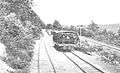 A car near the Five Mile Tree crossover bridge.
 About halfway up, where the up and down tracks crossed.
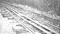 The track, with cables and safety ratchet.
- Looking up Mount Pisgah.
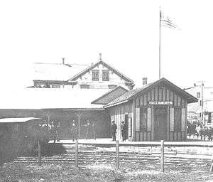 The Summit Hill station.
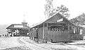 The Mauch Chunk station.
- Over and Under, up or down
References
- 1 2 National Park Service (2010-07-09). "National Register Information System". National Register of Historic Places. National Park Service.
- ↑ "Switchback Railroad - PHMC Historical Markers". Historical Marker Database. Pennsylvania Historical & Museum Commission. Retrieved December 19, 2013.
- ↑ Heydinger, Earl J. (1964). "Railroads of the Lehigh Coal and Navigation Company: GROUP IX". Railway and Locomotive Historical Society Bulletin. Railway and Locomotive Historical Society. 110: 59–62. JSTOR 43518101.
- ↑ Bartholomew, Ann M.; Metz, Lance E.; Kneis, Michael (1989). DELAWARE and LEHIGH CANALS, 158 pages (First ed.). Oak Printing Company, Bethlehem, Pennsylvania: Center for Canal History and Technology, Hugh Moore Historical Park and Museum, Inc., Easton, Pennsylvania. ISBN 0930973097. LCCN 89-25150. , p. 140–141.
- ↑ needs both profile map and topo map
- 1 2 3 4 Pescovitz, David. "History: 1870". Inventing the Scream Machine. Encyclopædia Britannica, Inc. Retrieved February 9, 2008.
- 1 2 3 4 "CNJ Mauch Chunk Switchback". Retrieved February 9, 2008.
- ↑ "The Mauch Chunk, Summit Hill, and Switchback Gravity Railroad". Retrieved February 9, 2008.
- ↑ Vince Hydro's Insider's Guide to the Switchback, Jim Thorpe Insider's Press, 1999.
- ↑ "Mountain Bike Trails in Pennsylvania : Pocono Mountains Region Mountain Biking : Switchback Trail : bikekinetix.com". Retrieved February 9, 2008.
- ↑ "Switch Back Home Page". Retrieved February 9, 2008.
Sources
- "Switchback Gravity Railroad Historic Landscape Preservation Planning Study" (PDF). University of Pennsylvania. 2007. Retrieved 16 July 2012.
- Heydinger, Earl J. (1964). "Railroads of the Lehigh Coal and Navigation Company: GROUP IX". Railway and Locomotive Historical Society Bulletin. Railway and Locomotive Historical Society. 110: 59–62. JSTOR 43518101.
- Frederick C. Gamst in QUESTIONS & COMMENTS, FAQ's (Page 2 of 2), America's First, First Railroad, in 1795, Central Pacific Railroad Photographic History Museum, Copyright © 1999-2013, CPRR.org. All rights reserved. [Last updated 6/24/2011]
- Frederick C. Gamst (University of Massachusetts). The Transfer of Pioneering British Railroad Technology to North America. Central Pacific Railroad Photographic History Museum, Copyright © 2004 CPRR.org. [Last Updated 11/13/2004].
External links
| Wikimedia Commons has media related to Mauch Chunk Switchback Railway. |
- www.summit-hill.com - local historian, documents many scenes along the 18 mile round trip of the railway's loop.
- Facebook Topic site - Mount Pisgah and Flagstaff part
- Mauch Chunk, Summit Hill, & Switch-Back Railroad -Facebook main switchbackrr page, links to several photo albums on the period and railroad's history.
| Topics |   | |
|---|---|---|
| Lists by county |
| |
| Lists by city | ||
| Other lists | ||
| ||