Matool
| Matool Mattool | |
|---|---|
| village | |
 Mattool Estuary | |
| Coordinates: 11°57′29″N 75°17′39″E / 11.957955°N 75.294159°ECoordinates: 11°57′29″N 75°17′39″E / 11.957955°N 75.294159°E | |
| Country |
|
| State | Kerala |
| District | (Hindi: कण्णूर ) |
| Population (2011) | |
| • Total | 26,086 |
| Languages | |
| • Official | Malayalam, English |
| Time zone | UTC+5:30 (IST) |
| Telephone code | 0497284**** |
| ISO 3166 code | IN-KL |
| Vehicle registration | KL-13 |
| Website | http://mattoolonline.com |

Matool (also Mattul, is a place near Payangadi, several kilometres north of Kannur, in North Kerala, South India. The Valapattanam River meets the Arabian sea at Matool.
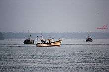
Matool is considered a boating destination with boat services to almost all coastal areas of Kannur district.
Demographics
As of 2011 India census, Mattool had a population of 26,086 with 12,094 males and 13,992 females.[1]
Distance from close by areas
Matool is located 19 KM towards North from District head quarters Kannur. 22 KM from Payyannur
To reach Matool>> By Train : Payangadi and Kannapuram are the closest railway stations // By Road : Payangadi Bus station is the closest Bus stand // By Air : Kannur Airport will be the closest Airport once it is completed.Currently Calicut Airport and Mangalore airport are the closest Airports to Matool.
History
Matool is the Arabic word (مأطول) meaning "how long" and is the name given by Ibn Battuta when he travelled through the area.
People
Matool is largely populated by members of the Muslim community. Mattool boasts of 98% literacy. A good percent of them are well educated and are well placed in the government and private sector. Mattool has many firsts to its credit including the first Malayalam Qur'an translator. One-third of the population of Matool depends on agriculture and fishing, the major produces being coconut and mango.
Azheekal Estuary
As ecosystems, this is one of the estuaries that is under threat from human activities such as pollution and overfishing. This is also threatened by sewage, coastal settlement, land clearance and much more. Estuaries are affected by events far upstream, and concentrate materials such as pollutants and sediments. Land run-off and industrial, agricultural, and domestic waste enter rivers and are discharged into estuaries. Contaminants can be introduced which do not disintegrate rapidly in the marine environment, such as plastics, pesticides, furans, dioxins, phenols and heavy metals. Such toxins can accumulate in the tissues of many species of aquatic life. Industrial pollutants, such as phenols and heavy metals, can devastate fish stocks and damage the estuary soil. Estuaries tend to be naturally eutrophic because land run off discharges nutrients into estuaries. With human activities, land run-off also now includes the many chemicals used as fertilizers in agriculture as well as waste from livestock and humans. Excess oxygen depleting chemicals in the water can lead to hypoxia and the creation of dead zones. It can result in reductions in water quality, fish, and other animal populations.
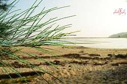
Long Beach
Mattool beach is west of the hamlet, Mattool . The beach is characterized by its excellent sand, seawall and clear water. There is a good view of Ezhimala Hill from the beach.
Schools
- Safa English Medium School, Mattool north under Manshau Mattool[2]
- C.H.M.K.S.G.H.S School - Mattool Central
- Mappila U.P School - Mattool Central
- Little Flower U.P School - Mattool Central
- C.M.L.P School - Mattool North
- N.M.U.P School - Mattool North
- Najath.G.H School - Mattool North
- Muneer.L.P School - Mattool North
- Devi Vilasam L.P. School - Mattool North
- M.R.U.P School - Mattool South
- G.M.L.P School - Mattool South
- Irfania Junior College ,Mattul North
- Quran Study Center , Mattul South
Hospitals & Clinics
- Mattool Government Hospital
- Medway Health Clinic
- Mahad Ayurvedic Clinic
- Veterinary Dispensary, Mattool
- C.H. Centre Mattool South
Doctors
Dr.Mubeena ETP,Matool North (BAMS,Ayurveda)
Transportation
The national highway passes through Taliparamba town. Goa and Mumbai can be accessed on the northern side and Cochin and Thiruvananthapuram can be accessed on the southern side. The road to the east of Iritty connects to Mysore and Bangalore. The nearest railway station is Pazhayangadi on Mangalore-Palakkad line. Trains are available to almost all parts of India subject to advance booking over the internet. There are airports at Kannur, Mangalore and Calicut. All of them are international airports but direct flights are available only to Middle Eastern countries.
See also
References
- ↑ "Census of India : Villages with population 5000 & above". Registrar General & Census Commissioner, India. Archived from the original on 2008-12-08. Retrieved 2008-12-10.
- ↑ "Manshau Thazkiyathi Sunniyathil Islamiyya – Mattool, Kannur". manshau.com. Retrieved 2016-08-06.
| Wikimedia Commons has media related to Mattool. |