Matamoros–Brownsville metropolitan area
| Matamoros–Brownsville | |
|---|---|
| Metropolitan area | |
 Primary urban area of Matamoros–Brownsville | |
| Countries |
|
| States |
|
| Principal cities |
Matamoros Brownsville - Harlingen - Raymondville |
| Population (2010 est.) | |
| • Metro | 1,136,995 (110th) |
| Time zone | UTC-6 (CST) |
| • Summer (DST) | UTC-5 (CDT) |
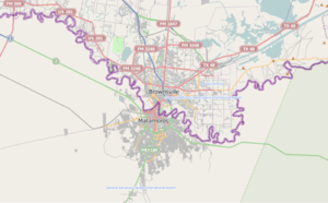
Matamoros–Brownsville,[1] also known as Brownsville–Matamoros,[2] or simply as the Borderplex,[3] is one of the six bi-national metropolitan areas along the Mexico–United States border.[4] The city of Matamoros is situated in the Mexican state of Tamaulipas, on the southern bank of the Rio Grande, while the city of Brownsville is located in the American state of Texas, directly north across the bank of the Rio Grande. The Matamoros–Brownsville is connected by four international bridges.[5] In addition, this transnational conurbation area has a population of 1,136,995,[6] making it the 4th largest metropolitan area in the Mexico-US border.[7]
The area of Matamoros–Brownsville lies among the top ten fastest growing urban areas in the United States.[8] The Brownsville–Harlingen and the Brownsville–Harlingen–Raymondville metropolitan areas are included in the official countdown of this transnational conurbation.
Municipalities/counties
Communities
Note: Principal cities are bolded.
Cities in Mexico
Populated places
Note: Within the municipality of Matamoros.[9]
- Control
- Estación Ramírez
- Buena Vista
- Las Rusias
- Santa Adelaida
- La Gloria
- Sandoval
- México Agrario
- 20 de Noviembre
- Ignacio Zaragoza
- Unión
Villages
Cities in the U.S.
Towns
Villages
Census-designated places
See also
References
- ↑ Herzog, Lawrence A. "Cross-Border Planning and Cooperation" (PDF). The U.S.-Mexican Border Environment. Archived from the original (PDF) on 21 March 2012. Retrieved 5 November 2011.
- ↑ "Brownsville MSA and Matamoros" (PDF). Brownsville Economic Development Counci. Archived from the original (PDF) on 25 April 2012. Retrieved 5 November 2011.
- ↑ "One river, one country". The Economist Newspaper. Retrieved 5 November 2011.
- ↑ "The U.S.-Mexican borderlands region: a binational spatial analysis" (PDF). The Social Science Journal 38. Retrieved 5 November 2011.
- ↑ "Border Wait Times". U.S. Customs and Border Protection. Retrieved 5 November 2011.
- ↑ "Matamoros-Brownsville". World Gazetteer. Archived from the original on 2012-05-13. Retrieved 22 August 2011.
- ↑ "World Gazetter: America - Largest Cities". Archived from the original on 2007-10-01.
- ↑ "State of the art facilities: McAllen". Aries Freight Systems. Archived from the original on 23 November 2011. Retrieved 3 November 2011.
- ↑ "MUNICIPIO DE H. MATAMOROS" (PDF). Gobierno de Tamaulipas. Archived from the original (PDF) on 23 May 2012. Retrieved 28 November 2011.
- ↑ "Plan Municipal de Desarrollo Rural Sutentable" (PDF). Gobierno Municipal de Matamoros. Retrieved 28 November 2011.
- ↑ "Localidades en el Municipio de Matamoros". Pueblos America. Retrieved 28 November 2011.
- ↑ "Matamoros, Tamaulipas | Estado fuerte para todos". Gobierno del Estado de Tamaulipas, México. Retrieved 28 November 2011.