Marion Township, Douglas County, Kansas
| Marion Township | |
|---|---|
| Township | |
 Globe Glass Works in Globe (2009). | |
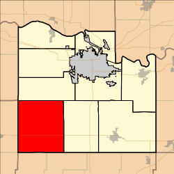 Location in Douglas County | |
| Coordinates: 38°48′20″N 095°25′41″W / 38.80556°N 95.42806°WCoordinates: 38°48′20″N 095°25′41″W / 38.80556°N 95.42806°W | |
| Country | United States |
| State | Kansas |
| County | Douglas |
| Area | |
| • Total | 71.93 sq mi (186.29 km2) |
| • Land | 71.55 sq mi (185.32 km2) |
| • Water | 0.37 sq mi (0.96 km2) 0.52% |
| Elevation | 1,099 ft (335 m) |
| Population (2000) | |
| • Total | 836 |
| • Density | 11.7/sq mi (4.5/km2) |
| GNIS feature ID | 0479476 |
Marion Township is a township in Douglas County, Kansas, USA. As of the 2000 census, its population was 836. It was named after the former town of Marion which in turn was named after Francis Marion.
Geography
Marion Township covers an area of 71.93 square miles (186.3 km2) and contains no incorporated settlements. According to the USGS, it contains five cemeteries: Appanoose, Colyer, Dodder, Rock Creek and Twin Mounds.
Adjacent townships
- Clinton Township, Douglas County (north)
- Willow Springs, Douglas County (east)
- Centropolis Township, Franklin County (southeast)
- Appanoose Township, Franklin County (south)
- Junction Township, Osage County (southwest)
- Elk Township, Osage County (west)
Towns and settlements
Although these towns may not be incorporated or populated, they are still placed on maps produced by the county.
Transportation
Major highways
Places of interest
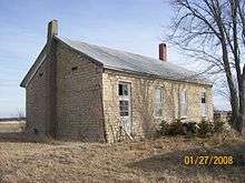
Twin Mound School in 2008.
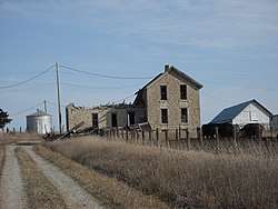
Simmon's Stage Station in 2009.
- Lone Star Lake, about four and half miles south of Clinton Lake offers boating, fishing, camping and swimming during certain times of the year.
- Simmons Point Station, an old stone house along the Santa Fe Trail that used to be a resting place and way station.[1]
- Townsite of Marion. Located along U.S. Highway 56, the town was named for Francis Marion and was known as both Marion and Globe.
- Townsite of Baden, located one mile (1.6 km) east of the Osage county line.
- Twin Mound School, one of the best preserved one-room schoolhouses in the county and the last one to be consolidated in 1966.
References
- ↑ Knox, Ron (May 14, 2006). "Time is Running Out for Historic Structure". Lawrence Journal-World. Retrieved January 28, 2018.
- "Township of Marion". Geographic Names Information System. United States Geological Survey. 13 October 1978. Retrieved 2009-07-15.
External links
Municipalities and communities of Douglas County, Kansas, United States | ||
|---|---|---|
| Cities |  | |
| Unincorporated communities | ||
| Ghost towns | ||
| Townships | ||
This article is issued from
Wikipedia.
The text is licensed under Creative Commons - Attribution - Sharealike.
Additional terms may apply for the media files.