Simmons Point Station
Coordinates: 38°47′02″N 95°26′04″W / 38.783847°N 95.434518°W
| Simmons Point Station | |
|---|---|
| Way Station | |
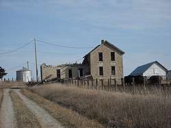 The Simmons Point Station in 2009. | |
| Country | United States |
| State | Kansas |
| County | Douglas |
| Time zone | Central (CST) |
| Area code(s) | 785 |
Simmons Point Station is the name of a house near the unincorporated settlement of Globe in Marion Township, Douglas County, Kansas. The building was constructed in the 1880s as a way station for travelers on the Santa Fe Trail.[1][2][3] Today, it is in an advanced state of deterioration and nearing collapse.[2]
References
- ↑ Staresinic-Deane, Diana (August 6, 2013). "Exploring the Santa Fe Trail: Douglas County, Kansas". dianastaresinicdeane. Wordpress. Retrieved January 28, 2018.
- 1 2 Knox, Ron (May 14, 2006). "Time is Running Out for Historic Structure". Lawrence Journal-World. Retrieved January 28, 2018.
- ↑ "Simmons Point Station". Lawrence Journal-World. May 14, 2006. Retrieved January 28, 2018.
Municipalities and communities of Douglas County, Kansas, United States | ||
|---|---|---|
| Cities |  | |
| Unincorporated communities | ||
| Ghost towns | ||
| Townships | ||
This article is issued from
Wikipedia.
The text is licensed under Creative Commons - Attribution - Sharealike.
Additional terms may apply for the media files.