Grant Township, Douglas County, Kansas
| Grant Township | |
|---|---|
| Township | |
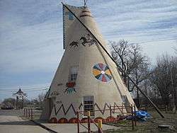 A teepee at TeePee Junction north of Lawrence. | |
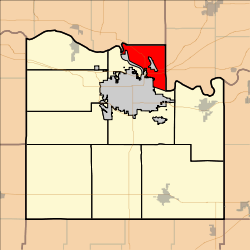 Location in Douglas County | |
| Coordinates: 39°01′20″N 095°14′01″W / 39.02222°N 95.23361°WCoordinates: 39°01′20″N 095°14′01″W / 39.02222°N 95.23361°W | |
| Country | United States |
| State | Kansas |
| County | Douglas |
| Area | |
| • Total | 16.56 sq mi (42.88 km2) |
| • Land | 16.44 sq mi (42.57 km2) |
| • Water | 0.12 sq mi (0.32 km2) 0.75% |
| Elevation | 830 ft (253 m) |
| Population (2000) | |
| • Total | 442 |
| • Density | 26.9/sq mi (10.4/km2) |
| GNIS feature ID | 0478832 |
Grant Township is a township in Douglas County, Kansas, USA. As of the 2000 census, its population was 442.
History
Grant Township was annexed from the extreme southern portion of Sarcoxie Township in Jefferson County in 1872. The largest town was called Jefferson until it was renamed North Lawrence in 1870.
Geography
Grant Township covers an area of 16.56 square miles (42.9 km2) and contains no incorporated settlements. According to the USGS, it contains one cemetery, Maple Grove.
Adjacent Townships
- Rural Township, Jefferson County (northwest)
- Sarcoxie Township, Jefferson County (north)
- Reno Township, Leavenworth County (east)
- Wakarusa Township, Douglas County (south)
Towns and Settlements
Although these towns may not be incorporated or populated, they are still placed on maps produced by the county.
Transportation
Major highways
- I-70, part of the Kansas Turnpike
- U.S. Highway 24
- U.S. Highway 40
- U.S. Highway 59
- K-32
Places of interest
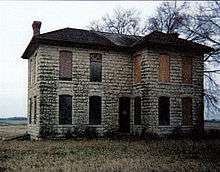
The Vermilya-Boener House in Grant Township. Listed on the National Register of Historic Places, the house is now considered an endangered site.[1]
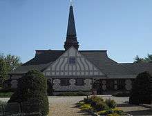
The Lawrence Visitors Center, formerly the Union Pacific Depot
- Located near Lyon Street and North 9th Street, just outside North Lawrence was the community of Bismarck Grove which held fairs and chautauquas between 1878 and 1900.
- Riverfront Park is a park maintained by the Army Corps of Engineers that follows the Kansas River levee from Leavenworth County to Jefferson County
- The Union Pacific Railroad Depot was designed by Henry Van Brunt and built in 1889. It was used until 1984, was saved from demolition and is now the Lawrence Visitors Information Center.
References
- "Township of Grant". Geographic Names Information System. United States Geological Survey. 13 October 1978. Retrieved 2009-07-15.
External links
Municipalities and communities of Douglas County, Kansas, United States | ||
|---|---|---|
| Cities |  | |
| Unincorporated communities | ||
| Ghost towns | ||
| Townships | ||
This article is issued from
Wikipedia.
The text is licensed under Creative Commons - Attribution - Sharealike.
Additional terms may apply for the media files.