Mandres-les-Roses
| Mandres-les-Roses | ||
|---|---|---|
| Commune | ||
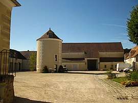 The Ferme de Monsieur, an historic monument in Mandres-les-Roses | ||
| ||
 Paris and inner ring departments | ||
| Coordinates: 48°42′08″N 2°32′40″E / 48.7022°N 2.5444°ECoordinates: 48°42′08″N 2°32′40″E / 48.7022°N 2.5444°E | ||
| Country | France | |
| Region | Île-de-France | |
| Department | Val-de-Marne | |
| Arrondissement | Créteil | |
| Canton | Plateau briard | |
| Intercommunality | Grand Paris | |
| Area1 | 3.3 km2 (1.3 sq mi) | |
| Population (2008)2 | 4,342 | |
| • Density | 1,300/km2 (3,400/sq mi) | |
| Time zone | UTC+1 (CET) | |
| • Summer (DST) | UTC+2 (CEST) | |
| INSEE/Postal code | 94047 / | |
|
1 French Land Register data, which excludes lakes, ponds, glaciers > 1 km2 (0.386 sq mi or 247 acres) and river estuaries. 2 Population without double counting: residents of multiple communes (e.g., students and military personnel) only counted once. | ||

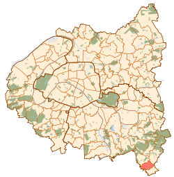
Mandres-les-Roses is a commune in the southeastern suburbs of Paris, France. It is located 22.1 km (13.7 mi) from the center of Paris. The palaeographer and archivist Robert Marichal (1904–1999) was born in Mandres-les-Roses.
Transport
Mandres-les-Roses is served by no station of the Paris Métro, RER, or suburban rail network. The closest station to Mandres-les-Roses is Boussy-Saint-Antoine station on Paris RER line D. This station is located in the neighboring commune of Boussy-Saint-Antoine, 2.5 km (1.6 mi) from the town center of Mandres-les-Roses.
See also
Education
There are two schools in the commune, Ecole Maternelle la Ferme de Monsieur (preschool/nursery) and an elementary school building.[1]
References
- INSEE
- Mayors of Essonne Association (in French)
- ↑ "Affaires scolaires." Mandres-les-Roses. Retrieved on September 10, 2016.
External links
| Wikimedia Commons has media related to Mandres-les-Roses. |
- Home (in French)