Mandsaur
| Mandsaur Dashpur | |
|---|---|
| City | |
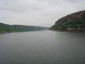 River Chambal in Gandhi Sagar Sanctuary | |
 Mandsaur  Mandsaur | |
| Coordinates: 24°02′N 75°05′E / 24.03°N 75.08°ECoordinates: 24°02′N 75°05′E / 24.03°N 75.08°E | |
| Country | India |
| State | Madhya Pradesh |
| District | Mandsaur |
| Government | |
| • Mayor | Mr. Prahalad Bandhwar |
| Languages | |
| • Official | Hindi |
| Time zone | UTC+5:30 (IST) |
| PIN | 458001 |
| Telephone code | 07422 |
| Vehicle registration | MP-14 |
| Website |
www |
Mandsaur or Mandsour is a city in the Malwa region and district of Madhya Pradesh state of central India. It is the administrative headquarters of Mandsaur District. The ancient Pashupatinath Temple is located in Mandsaur. Also Banjari Balaji Temple ,Nalchhamata are located in mandsaur. Bhavneshvar Mahadev mandir is newly developed, a hindu temple at labdadi near Udpura.
Origin of name
The name Mandsaur evolved from Marhsaur, which originated from Marh and Saur (or Dasaur), two of the villages which merged in the town. The town was known as Dashapura in ancient times. The city consists of ten 'puras', which gave it the name Dashpura.
It is also believed that this place was once the maternal residence of Mandodari, the wife of Ravana. In old city areas, people worship the idol of Ravana and avoid participating in the 'Ravana Dahan' (burning the idol of Ravana as a symbol of victory of good over evil )ritual on Vijayadashami(Dashahara) as they regard Ravana their son-in-law. A 35-feet ten headed sitting idol of Ravana can be seen in the Khanpura area of the city.
History
Aulikaras of Dashapura
Epigraphical discoveries have brought to light two ancient royal houses, who call themselves as Aulikaras and ruled from Dashapura (present-day Mandsaur). The first dynasty, who ruled from Dashapura from the beginning comprised the following kings in the order of succession: Jayavarma, Simhavarma, Naravarma, Vishvavarma and Bandhuvarma. Bandhuvarma was contemporary of Kumaragupta I. There is an inscription about Bandhuvarma at Mandsaur. The silk workers had constructed a Sun temple here which was repaired by Bandhuvarma in Samvat 493 (436 CE). This indicates that he was present there till 436 CE. The Risthal stone slab inscription discovered in 1983 has brought to light another Aulikara dynasty, which comprised the following kings in the order of succession: Drumavardhana, Jayavardhana Ajitavardhana, Vibhishanavardhana, Rajyavardhana and Prakashadharma. After Parakshadharma, the ruler of Mandsaur was Yashodharma, who is identified with Vishnuvardhana, who erected a pillar of victory at Bayana due to which Bayana’s name became Vijaygarh. In all probabilities, he was the son and immediate successor of Prakashadharma.[1] Yashodharma Vishnuvardhana assumed the title of Samrat after he occupied the territories of Bandhuvarma. It is also mentioned that Yashodharma Vishnuvardhana had assumed the title of ‘Maharajadhiraja’ or Emperor.
Yashodharman rule
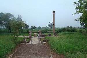
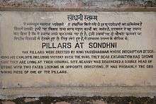
Sondani (सोंधनी) is a small village at a distance of about 4 km from Mandsaur situated on Mahu-Nimach Highway towards Mahu. Two monolith pillars were erected here by King Yasodharman in 528 AD with inscription which describe his exploits including victory over Hunas (Alchon Huns).[2][3] In a part of the inscription Yasodharman praises himself for having defeated king Mihirakula:[4]
"He (Yasodharman) to whose two feet respect was paid, with complimentary presents of the flowers from the lock of hair on the top of (his) head, by even that (famous) king Mihirakula, whose forehead was pained through being bent low down by the strength of (his) arm in (the act of compelling) obeisance"
— Sondani pillar inscription[5]
Excavations by the Indian Archaeology Department show that these pillars are lying at their original site. Nearby was discovered a double head of stone with two faces of lions looking in opposite directions. It was probably the crowning piece of one of the pillars. Each pillar is of height 40 feet, girth 3.5 feet and weighs 200 ton.,[2][6] The inscription bears verses composed by the poet Vasula, the son of Kakka. This eulogy has been engraved by Govinda. The composition is in Sanskrit language and script is north Indian brahmi.,[7][8] Nagappa and Dasappa were two south Indian artisans who gave shape to these pillars. These pillars were discovered by British officer Sulvin in 1875. John F. Fleet discovered their other pieces. In 1921 Shri V.S. Garde, Director Archaeology Gwalior state, made a terrace and put these pillars over it.[7]
Gurjara-Pratihara Dynasty
The Gurjara Pratihara empire was extended up to Mandasor during the reign of Mahendrapala II.[9]
Dilawar Khan Ghauri
The Mandsaur city is situated on the border of Malwa and Mewar and as such is strategically very important. After the attack of Timur, the Delhi Sultanate became weak. Dilawar Khan Ghauri was governor of the Malwa province of central India during the decline of the Delhi Sultanate. Dilawar Khan declared himself Sultan of Malwa in 1401, and passed the kingdom to his son Hoshang Shah upon his death. Thus he had practically come to Mandu in 1401 as the first sultan of Malwa. Dilawar had also shifted the capital from Dhar to Mandu, renaming it Shadiabad, the city of joy. The successor of Dilawar Khan Gauri was Hushang Shah Gori (1405–1435), who constructed fort at strategically important Mandsaur city to strengthen his north-west boundary.[10] In 1519 Rana Sanga occupied the fort and appointed Ashokmal Rajput as its Kiledar. In 1535 Humayun also stayed here for few months during his Malwa expedition. During Sher Shah period Sadar Khan was appointed its Kiledar.[11] During the reign of Akbar Mandsaur got the status of sarkar. In 1733 the Malwa subedar of Mughals Sawai Jaisingh attacked the fort but was defeated by Marathas and the fort went to Marathas.[12] The historically most important event in the fort was the treaty of 1818 between Tantiya Jog senapati of Malhar Rao Holkar II and Sir John Malcum under which Malwa came in occupation of British rule.[13][14] There are two gardens in which there is a pillar of torandwar. It is believed to be pillar of Surya Mandir of the inscription of Bandhu Varma. There is a Shiva statue also in the garden.[14]
Princely State
In 19th century before India's independence in 1947, Mandsaur was part of the princely state of Gwalior. It gave its name to the treaty with the Holkar Maharaja of Indore, who concluded the Third Anglo-Maratha War and the Pindari War in 1818. At the turn of the 20th century it was a centre of the Malwa opium trade.
Geography
Mandsaur District forms the northern projection of Madhya Pradesh from its western Division, i.e., Ujjain Commissioner's Division. It lies between the parallels of latitude 230 45' 50" North and 250 2' 55" North, and between the meridians of longitude 740 42' 30" East and 750 50' 20" East.
The District is an average size district of Madhya Pradesh. It extends for about 142 km. from north to south and 124 km. from east to west. The total area is 5521 km² with a population of 116483 in 2001.
Demographics
As of 2001 India census,[15] Mandsaur had a population of 116,483. Males constitute 52% of the population and females 48%. Mandsaur has an average literacy rate of 71%, higher than the national average of 59.5%: male literacy is 78%, and female literacy is 64%. In Mandsaur, 13% of the population is under 6 years of age.
Transport
- Road: Mandsaur is situated on Ajmer-Lebad(Indore) NH-79 as well as Mhow-Neemuch SH-31 4 Lane road.
- Rail: Mandsaur railway station is situated on Ajmer-Ratlam track of Indian Railways and is under Ratlam rail division of WR. Currently It has a no electrified track. The work for Ratlam- Chittorgarh electrical track has been started, which is in progress. Currently there are 12 trains available from Mandsaur. Mandsaur has direct trains for Mumbai, Delhi, Hyderabad, Kolkata, Jaipur, Nathdwara, Okha, Ajmer, Udaipur, Agra, Kota, Indore, Ujjain, Bhopal, Harda, Ratlam, Chittaurgarh.
The major trains passing from Mandsaur are:-
- Bandra Terminus Udaipur Superfast Express
- Veer Bhumi Chittaurgarh Express
- Jodhpur - Indore Express
- Jaipur - Hyderabad Weekly Express
- Jaipur – Hyderabad SF Express
- Ratlam - Udaipur City Express
- Bhopal–Jaipur Express
- Bandra Terminus Udaipur Express
- Ajmer Bandra Terminus Express
- Indore–Jaipur Express via Ajmer
- Okha - Nathdwara Express
- Mandsaur - Meerut City Link Express
- Haldighati Passenger
- Indore - Bhilwara DMU
- Indore - Chittorgarh DMU
- Jaipur - Yesvantpur Suvidha Express
- Haldighati Passenger
- Udaipur Mysore Humsafar Express
- Local: Auto and Nager Seva are main source of local transport in Mandsaur
Tourism
Mandsaur and its neighborhood are full of places of tourist interest. An inscription discovered near the town indicated the erection of a temple of the sun in 437, and at Sondani are two great monolith pillars recording a victory of Yasodharman, king of Malwa, in 528. The fort dates from the 14th and 15th centuries. Hindu and Jain remains are numerous, though the town is predominantly Muslim.
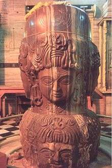
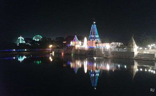
Mandsaur is also famous for Pashupatinath Temple, a Hindu temple situated on the banks of the Shivana river. Pashupatinath Temple is one of the prominent shrines in Mandsaur of Madhya Pradesh. Lord Shiva in the form of Lord Pashupatinath is the principal deity here. The highlight is a unique Shivling with eight faces of Lord Shiva. The shrine has four doors in four directions.
Shree Bahi Parshwanath Digambar Jain Atishay Kshetra
Shree Bahi Parshwanath Digambar Jain Atishay Kshetra is situated 12 km from Mandsaur. This place is constructed with the blessing and inspirations from Acharya Shree Kalyan Sagar Ji Maharaj, also known as "Namokar Mahamantra Sadhana Kendra, Vahi Parshavanatha Chaupati". Moolnayak of this temple is a 58 cm high, black-colored idol of Parshvanath in the Padmansana posture. Since this tirth is in Vahinagar, the idol is called Vahi Parshvanath.
Teliya Talaab or teliya tank
A source of the utility water supply for the city pupils and also famous as a tourist attraction. This particular lake known as Teliya Talaab has developed into more of a family and friends gathering place with a park and a temple near by. Inhabitants including people of every caste and age often spend their time here in the evenings and or the holidays.
Anugrah Church (CNI) Mandsaur
There is a beautiful 35 Years old church near BSNL Tower. It is a branch of CNI group of churches. In the premises of church there is a beautiful 150 years old British era cemetery near to church.
Gandhi Sagar Sanctuary
River Chambal in Gandhi Sagar Sanctuary The Gandhi Sagar Dam is the first of the four dams built on the Chambal river. It is located in the Mandsaur district of Madhya Pradesh. It is a 64 metre high masonry gravity dam, with a live storage capacity of 6,920 million cubic metres and a catchment area of 22,584 km2. The dam was completed in 1960. The hydro-power station comprises five generating units of 23 MW capacity each. The water released after power generation is used for power generation at Jawahar Sagar Dam and is used for irrigation through Kota Barrage.
Gandhi Sagar Sanctuary is wildlife sanctuary situated on the northern boundary of Mandsaur and Nimach districts in Madhya Pradesh, India. It is spread over an area of 368.62 km squire adjoining Rajasthan state in India. It was notified in 1974 and more area was added in 1983. The Chambal River passes through the sanctuary and divides into two parts. The western part is in Nimach district and eastern part is in Mandsaur district.
Mandsaur Fort
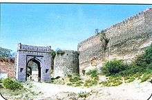
Mandsaur Fort, also known as Dashpur Fort, is situated in Mandsaur city in Mandsaur district in Madhya Pradesh state of India.[16] The Mandsaur city is situated on the border of Malwa and Mewar and as such is strategically very important. After the attack of Timur, the Delhi Sultanate became weak. Dilawar Khan Ghauri was governor of the Malwa province of central India during the decline of the Delhi Sultanate. Dilawar Khan declared himself Sultan of Malwa in 1401, and passed the kingdom to his son Hoshang Shah upon his death. Thus he had practically come to Mandu in 1401 as the first King of Malwa. Dilawar had also shifted the capital from Dhar to Mandu, renaming it Shadiabad, the city of joy. The successor of Dilawar Khan Gauri was Hushang Shah Gori (1405–1435), who constructed fort at strategically important Mandsaur city to strengthen his north-west boundary.[10] He is also remembered for his wonderful taste in architecture.
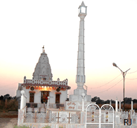
Shree Khade Balaji Temple
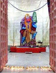
An old temple of Shree Khade Balaji (Hanuman ji). It is very old Hindu temple with interiors done with stones. A worth visit place. It is near to Gandhi Chauraha, in heart of Mandsaur.
Bandi Ji Ka Baag
A Temple with Glass interiors. Bandi Ji Ka Baag is a 120 Yrs old Jain temple with interiors done with Glass. A worth visit place. It is very near to Main Bus Stand. The temple currently has a "Maan Stambh", built when temple celebrated 100 years of establishment.
- School:
- Karni International School
(http://www.karniinternationalschool.com)
- Lotus Valley School, Mandsaur (http://lvsmandsaur.com/)
- Subhash English School
- Kamla Nehru Bal Mandir
- Mandsaur International School
- St. Thomas Sr. Sec. School (http://www.stthomasschool.co.in/)
- Dashpur Vidhya Mandir
- Vatsalya Public School (http://www.vatsalyapublicschool.com/)
- Kendriya Vidyalaya Mandsaur (http://kvmandsaur.org.in/)
- Dashpur Vidyalaya (http://www.dashpurvidyalaya.org)
- Saraswati Shishu mandir, Keshav Nagar
- Saraswati Vidya Mandir, Sanjeet Marg(http://www.saraswatividyamandir.in/)
- School Of Excellence, Mandsaur
- Bhartiya Vidhya Mandir, Choudhary Colony
- Jhalani Mahila Vidyapeeth.
- NS Sanghvi School Mandsaur
- Engineering University: Mandsaur Institute of Technology (http://mitmandsaur.brnss.org/)
- Pharmacy Colleges:
- B.R.Nahata College of Pharmacy (http://www.brncop.org/).
- Mandsaur Institute of Pharmacy.
- Law college: JL Nehru Law College.
- College of Horticulture, Sitamau Road, Mandsaur
See also
References
- ↑ Agarwal, Ashvini (1989). Rise and Fall of the Imperial Guptas, Delhi:Motilal Banarsidass, ISBN 81-208-0592-5, pp.250-6
- 1 2 Usha Agarwal:Mandsaur Zile Ke Puratatvik samarakon ki paryatan ki drishti se sansadhaniyata - Ek Adhyayan, Chirag Prakashan Udaipur, 2007, p. 19
- ↑ Mangal Mehta (Ed): Dashpur Janapada aur sanskriti, p. 142
- ↑ Coin Cabinet of the Kunsthistorisches Museum Vienna
- ↑ Punjab Monitor, April 2013 , from Fleet, John F. Corpus Inscriptionum Indicarum: Inscriptions of the Early Guptas. Vol. III. Calcutta: Government of India, Central Publications Branch, 1888, 147-148.
- ↑ H.Michael Brown (Ed): Gwalior Today, p. 180
- 1 2 Usha Agarwal:Mandsaur Zile Ke Puratatvik samarakon ki paryatan ki drishti se sansadhaniyata - Ek Adhyayan, Chirag Prakashan Udaipur, 2007, p. 20
- ↑ Sriram Goyal:Guptakalin Abhilekh, p. 366
- ↑ Rama Shankar Tripathi (1989). History of Kanauj: To the Moslem Conquest. Motilal Banarsidass Publ. p. 269. ISBN 978-81-208-0404-3.
- 1 2 Sikandar bin Mahmud:Mirat-e-Sikandar, p. 113
- ↑ H.Mikal Brown (Ed): Gwalior Today, 180
- ↑ Raghuvir Singh:Madhyakalin Mandsaur mien huee Bharatiy Itihas ki kuchh nirnayak ghatnaen, p. 12
- ↑ Mandsaur district gazetteer, p. 42
- 1 2 Usha Agarwal:Mandsaur Zile ke Puratatvik samarakon ki paryatan ki drishti se sansadhaniyata - Ek Adhyayan, Chrag Prakashan Udaipur, 2007, p. 19
- ↑ "Census of India 2001: Data from the 2001 Census, including cities, villages and towns (Provisional)". Census Commission of India. Archived from the original on 2004-06-16. Retrieved 2008-11-01.
- ↑ Usha Agarwal:Mandsaur Zile ke Puratatvik samarakon ki paryatan ki drishti se sansadhaniyata - Ek Adhyayan, Chrag Prakashan Udaipur, 2007, p. 18
