Malmö Municipality
| Malmö Municipality Malmö kommun Malmö stad | ||
|---|---|---|
| Municipality | ||
.jpg) Municipal building | ||
| ||
 | ||
| Country | Sweden | |
| County | Scania | |
| Seat | Malmö | |
| Government | ||
| • Mayor | Katrin Stjernfeldt Jammeh (S) | |
| Area[1] | ||
| • Total | 332.64 km2 (128.43 sq mi) | |
| • Land | 156.87 km2 (60.57 sq mi) | |
| • Water | 175.77 km2 (67.87 sq mi) | |
| Area as of 1 January 2014. | ||
| Population (31 December 2017)[2] | ||
| • Total | 333,633 | |
| • Density | 1,000/km2 (2,600/sq mi) | |
| Time zone | UTC+1 (CET) | |
| • Summer (DST) | UTC+2 (CEST) | |
| ISO 3166 code | SE | |
| Province | Scania | |
| Municipal code | 1280 | |
| Website | www.malmo.se | |

Malmö Municipality (Swedish: Malmö kommun [²malːmøː kɔˈmuːn]), or City of Malmö (Malmö stad [²malːmøː ˈstɑːd]), is a municipality in Scania, the southernmost Swedish province.
When the first Swedish local government acts were implemented in 1863, the Old City of Malmö was made one of the country's 88 city municipalities and the first city council was elected. The municipal territory has been augmented through mergers in 1911, 1915, 1931, 1935, 1952, 1967 and finally in 1971.
In 1971, the city was also converted into a municipality of unitary type, like all others in Sweden. Malmö Municipality, however, styles itself Malmö stad (City of Malmö) in all cases when it is legally possible. This is a decision taken by the municipal assembly. It is purely nominal and has no effect on the legal status of the municipality.
Localities
There are nine urban areas (also called a tätort or locality) and four smaller localities (småorter) in the municipality.[3][4]
The localities are listed in the table according to the size of the population in 2010. The municipal seat is in bold characters.
Note that a small part of Malmö (Arlöv) is situated in Burlöv Municipality.
| # | Locality | Population |
|---|---|---|
| 1 | Malmö | 270,214 |
| 2 | Oxie | 11,493 |
| 3 | Bunkeflostrand | 10,386 |
| 4 | Tygelsjö | 2,710 |
| 5 | Södra Klagshamn | 1,367 |
| 6 | Vintrie | 670 |
| 7 | Västra Klagstorp | 279 |
| 8 | Toarp | 219 |
| 9 | Skumparp | 205 |
| 10 | Slättäng | 98 |
| 10 | Lockarp | 54 |
| 11 | Pile-Tygelsjö | 52 |
| 12 | Krumby | 52 |
City districts
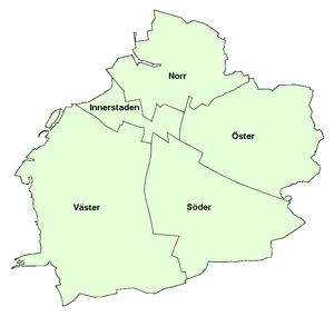
After a reform on 1 July 2013, Malmö Municipality is divided into five city districts (Swedish: stadsområde).[5][6] They manage public kindergartens, schools, and geriatric care within their geographical areas, and provide funds for local cultural and recreational activities.
There are 136 neighbourhoods.[7]
| Inhabitants as of 1 January 2013[8] | |
| Väster | 75,600 |
| Innerstaden | 67,900 |
| Norr | 62,100 |
| Söder | 56,300 |
| Öster | 44,300 |

Before the reform on July 2013, Malmö Municipality was divided into ten city districts (Swedish: stadsdel) after the 1996 City District Reform (Swedish: stadsdelsreformen).
| City district | Population[9] | Area (hectare)[10] |
Density (people/km²) |
|---|---|---|---|
| Centrum | 47,171 | 1,757 | 2,685 |
| Fosie | 43,889 | 1,243 | 3,531 |
| Limhamn-Bunkeflo | 42,646 | 5,147 | 829 |
| Södra Innerstaden | 34,671 | 302 | 11,480 |
| Västra Innerstaden | 33,191 | 465 | 7,138 |
| Hyllie | 32,998 | 901 | 3,662 |
| Rosengård | 23,563 | 332 | 7,097 |
| Husie | 20,769 | 2,948 | 705 |
| Kirseberg | 14,959 | 640 | 2,337 |
| Oxie | 12,453 | 2,306 | 540 |
Local government
The municipal legislative body of the municipality is the 61-member municipal assembly (kommunfullmäktige), elected by proportional representation for a four-year term. The assembly appoints the municipality's main governing bodies, the 11-member executive committee (kommunstyrelsen) and the 8 governing commissioners. The executive committee and the commissioners are headed by a municipal commissioner (kommunstyrelsens ordförande) or "mayor". The mayor is Katrin Stjernfeldt Jammeh of the Social Democratic Party.[11]
There are seven political parties represented in the council elected in 2014: Social Democratic Party (21 seats), Moderate Party (14), Sweden Democrats (9), Green Party (6), Left Party (6), Liberal People's Party (3) and Feminist Initiative (2).[12]
International cooperation
Twin towns — Sister cities
As of 2011, Malmö has town twinning treaties or treaties of co-operation signed with 13 cities. Of these, cooperation is closest with Newcastle, Tallinn, the province of Chieti and with Vaasa.
The complete list of cities is the following:[13]
|
See also
References
- ↑ "Statistiska centralbyrån, Kommunarealer den 1 januari 2014" (Microsoft Excel) (in Swedish). Statistics Sweden. Retrieved 2014-04-18.
- ↑ "Folkmängd i riket, län och kommuner 31 december 2017" (in Swedish). Statistics Sweden. February 21, 2018. Retrieved February 21, 2018.
- ↑ "Folkmängd per tätort och småort 2010, per kommun". Statistics Sweden (in Swedish). 26 June 2013. Retrieved 20 January 2014.
- ↑ "Småorter 2010 (Smaller localities 2010)" (PDF). Statistics Sweden (in Swedish). 2010. Retrieved 20 January 2014.
- ↑ "Nystart för ett bättre Malmö". Malmö Municipality (in Swedish). 27 June 2013. Archived from the original on 1 February 2014. Retrieved 17 January 2014.
- ↑ "Malmös karta har ritats om". Sydsvenskan (in Swedish). 1 July 2013. Retrieved 17 January 2014.
- ↑ "Befolkning per stadsområde, stadsdel, delområde 2007-2014". Malmö Municipality (in Swedish). 13 April 2015. Archived from the original on 2015-11-26. Retrieved 2015-11-26.
- ↑ "Malmö in brief" (PDF). Malmö Municipality. December 2013. Retrieved 17 January 2014.
- ↑ "Befolkningsbokslut Malmö 2012" (PDF). Malmö Municipality (in Swedish). 17 June 2013. Archived from the original (PDF) on 1 February 2014. Retrieved 19 January 2014.
- ↑ "Blad1 (Areal)". Malmö Municipality (in Swedish). Archived from the original on 2 February 2014. Retrieved 19 January 2014.
- ↑ Source: Malmö City Council Archived 2007-09-29 at the Wayback Machine.
- ↑ "Valresultat - Malmö, Kommunval" (in Swedish). SVT. 22 September 2014.
- 1 2 3 4 5 6 7 8 9 10 11 12 "Vänorter" (in Swedish). Malmö stad. Archived from the original on 3 December 2013. Retrieved 6 November 2013.
- ↑ "MALMÖ/ İSVEÇ".
- ↑ "Kaliningrad - Partner Cities". City of Kaliningrad. Archived from the original on 22 April 2009. Retrieved 6 November 2013.
- ↑ "SISTER CITIES & TOWNS". Newsletter of the Municipality of Swakopmund. Retrieved 2011-09-01.
- ↑ "Kontakty partnerskie Miasta Szczecin". Urząd Miasta Szczecin (in Polish). Archived from the original on 2012-08-18. Retrieved 2013-07-29.
External links
Municipalities and seats of Skåne County | ||
|---|---|---|
| Municipalities | ||
| Municipal seats | ||
| Localities |
| |
|---|---|---|