Maimbung, Sulu
| Maimbung | |
|---|---|
| Municipality | |
| Municipality of Maimbung | |
 Map of Sulu with Maimbung highlighted | |
.svg.png) Maimbung Location within the Philippines | |
| Coordinates: 5°56′N 121°02′E / 5.93°N 121.03°ECoordinates: 5°56′N 121°02′E / 5.93°N 121.03°E | |
| Country |
|
| Region | Autonomous Region in Muslim Mindanao (ARMM) |
| Province | Sulu |
| District | 1st District |
| Barangays | 27 (see Barangays) |
| Government [1] | |
| • Type | Sangguniang Bayan |
| • Mayor | Samier Tan |
| • Electorate | 24,748 voters (2016) |
| Area [2] | |
| • Total | 77.50 km2 (29.92 sq mi) |
| Population (2015 census)[3] | |
| • Total | 37,914 |
| • Density | 490/km2 (1,300/sq mi) |
| Time zone | UTC+8 (PST) |
| ZIP code | 7409 |
| PSGC | 156605000 |
| IDD : area code | +63 (0)68 |
| Climate type | Tropical climate |
| Income class | 5th municipal income class |
| Revenue (₱) | 67,368,988.00 (2016) |
| Native languages |
Tausug Tagalog |
Maimbung, officially the Municipality of Maimbung, is a 5th class municipality in the province of Sulu, Philippines. According to the 2015 census, it has a population of 37,914 people.[3]
It is the seat of the Sultanate of Sulu.
Royal Capital
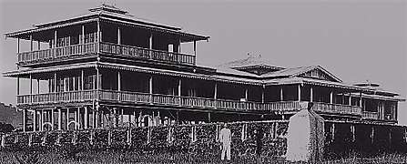
The town hosted the Daru Jambangan (Palace of Flowers) which was the royal palace of the Sultan of Sulu since historical times. The palace was made of wood, and was destroyed in 1932 by a huge storm. Today, a few arches and posts remain from the once grand palace complex. Many members of the royal family advocated for the reconstruction of the palace, and even its enlargement, however, the government of the Philippines has yet to establish a position or a fund for the matter.
The town was officially cited by the late Sultan Jamalul Kiram III of the Sultanate of Sulu as the capital of the sultanate, and the place where he wished he was buried after death. The late sultan died in 2013 and was buried in the town afterwards. The town hosts a school named after the late sultan.
In 2016, a small replica of Daru Jambangan was built in the neighboring town of Talipao and became a centerpiece for a 'vacation park'. The replica was about 25% of the actual size of the real Daru Jambangan during its heyday. A campaign to restore the Daru Jambanagn in its original location in Maimbung is still ongoing. The National Commission for Culture and the Arts and the National Museum of the Philippines were tasked to faithfully restore or reconstruct the Daru Jambangan in Maimbung.[4]
Port Town
The town is one of the three official ports of the province of Sulu, the other two being Jolo and Siasi. The town is also a known producer of seaweed, a major export product of the Sulu archipelago.
Barangays
Maimbung is politically subdivided into 27 barangays.
- Anak Jati
- Bato Ugis
- Bualo Lahi
- Bualo Lipid
- Bulabog
- Duhol Kabbon
- Gulangan
- Ipil
- Kandang
- Kapok-Punggol
- Kulasi
- Labah
- Lagasan Asibih
- Lantong
- Lapa
- Laud Kulasi
- Laum Maimbung
- Lower Tambaking
- Lunggang
- Matatal
- Patao
- Poblacion (Maimbung)
- Ratag Limbon
- Tabu-Bato
- Tandu Patong
- Tubig-Samin
- Upper Tambaking
Demographics
| Population census of Maimbung | ||
|---|---|---|
| Year | Pop. | ±% p.a. |
| 1903 | 1,070 | — |
| 1918 | 7,339 | +13.70% |
| 1939 | 11,228 | +2.05% |
| 1948 | 12,456 | +1.16% |
| 1960 | 14,302 | +1.16% |
| 1970 | 15,557 | +0.84% |
| 1975 | 17,166 | +1.99% |
| 1980 | 20,080 | +3.18% |
| 1990 | 17,251 | −1.51% |
| 1995 | 21,692 | +4.39% |
| 2000 | 24,982 | +3.07% |
| 2007 | 38,092 | +5.99% |
| 2010 | 28,445 | −10.08% |
| 2015 | 37,914 | +5.62% |
| Source: Philippine Statistics Authority[3][5][6] | ||
References
- ↑ "Municipality". Quezon City, Philippines: Department of the Interior and Local Government. Retrieved 31 May 2013.
- ↑ "Province: Sulu". PSGC Interactive. Quezon City, Philippines: Philippine Statistics Authority. Retrieved 12 November 2016.
- 1 2 3 Census of Population (2015). "ARMM – Autonomous Region in Muslim Mindanao". Total Population by Province, City, Municipality and Barangay. PSA. Retrieved 20 June 2016.
- ↑ https://eazytraveler.net/2014/11/sulu-sultan-royal-palace-replica/
- ↑ Census of Population and Housing (2010). "ARMM – Autonomous Region in Muslim Mindanao". Total Population by Province, City, Municipality and Barangay. NSO. Retrieved 29 June 2016.
- ↑ Censuses of Population (1903–2007). "ARMM – Autonomous Region in Muslim Mindanao". Table 1. Population Enumerated in Various Censuses by Province/Highly Urbanized City: 1903 to 2007. NSO.
External links
- Philippine Standard Geographic Code
- Philippine Census Information
- Local Governance Performance Management System
- CHR to exhume bodies of ‘Maimbung massacre victims'
Jolo (capital) | |
| Municipalities | |